
Maginot Line facts for kids

The Maginot Line (pronounced Mah-zhee-NOH Line) was a huge system of defenses built by French people. Its French name is French: Ligne Maginot. It included strong walls, forts, and underground bunkers. The French built it after World War I to protect their country. It was named after André Maginot, who was the French Minister of War at the time. The Maginot Line stretched along France's borders with Germany, Belgium, Luxembourg, and Italy. The parts facing Italy are sometimes called the Alpin Line. This massive defense system was built between 1930 and 1940.
Contents
What Was the Maginot Line?
The Maginot Line was not just a simple wall. It was a very complex system of fortifications. These included many bunkers, underground tunnels, and gun positions. It was designed to be a strong barrier against attacks. The French wanted to stop any enemy from easily entering their country.
Why Was It Built?
After the terrible fighting of World War I, France wanted to avoid another invasion. During World War I, the German Army had built a similar strong defense line called the Hindenburg Line. The French learned from this. They hoped the Maginot Line would make France safe. It was meant to stop an enemy attack long enough for the French army to get ready.
How Was It Designed?
The Maginot Line was built with many different parts. It had large forts with thick concrete walls. These forts were connected by underground tunnels. Inside, there were railways to move supplies and soldiers quickly. There were also smaller bunkers and machine gun posts. Some parts even had anti-tank barriers. These were designed to stop enemy tanks.
What Happened During World War II?
The French plan for the Maginot Line was simple. They thought it would force any attacking army to go around it. This would make the enemy enter Belgium instead. The French army would then move north into Belgium to meet them. They believed this would give them time to prepare for battle.
However, during World War II, the German army did not attack the strongest parts of the Maginot Line directly. Instead, they went around it. They attacked through a heavily forested area called the Ardennes. This area was thought to be too difficult for tanks to cross. The French did not extend the Maginot Line fully through this area.
The German army surprised the French by moving quickly through the Ardennes. They then attacked the French army from behind. The French army and the German army did meet in Belgium, as planned. But the German attack was very fast and powerful. The French army was defeated quickly. The Maginot Line, despite being very strong, could not stop the invasion.
Images for kids
-
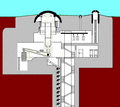
Side view diagram of the operation of a retractable turret: 75 mm gun of block 3 in Ouvrage Schoenenbourg
-
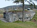
Casemate of Dambach Nord, Fortified Sector of the Vosges, Subsector of Philippsbourg
-
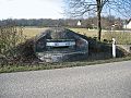
Blockhaus MOM (Main d'Oeuvre Militaire) de Richtolsheim – Secteur Fortifié de Colmar – Sous secteur de Hilsenheim
-
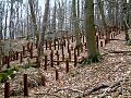
Anti-tank rails around casemate 9 of the Hochwald ditch
-
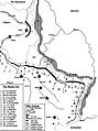
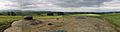
The principal fortified section of the Maginot Line
-
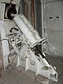
81 mm (3.2 in) mortar
-
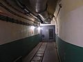
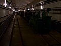
Corridor inside the Fort Saint-Gobain near Modane in the Alps. The Decauville
-
Combat block 1 at the fortress Limeiln (ouvrage Four-à-Chaux, Alsace), showing signs of German testing of explosives inside some fortresses between 1942 and 1944
-
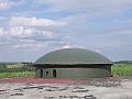
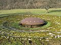
The view from a battery at Ouvrage Schoenenbourg in Alsace. A retractable turret is in the left foreground.
-

View of the village of Lembach in Alsace (north-east), taken from combat unit number 5 of the fortress ouvrage Four-à-Chaux
-
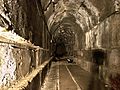
Tunnel, Ouvrage Schoenenbourg, the decauville
-
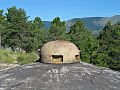
GFM cloche
-
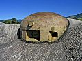
JM cloche
-

AM cloche
-

LG cloche
-

VP cloche
-

VDP cloche
-
75 mm (3.0 in) Turret model 1932
-

135 mm (5.3 in) Turret
-
81 mm (3.2 in) Turret
-

Machine-gun Turret
-

AM (Mixed-Weapons) Turret


_bloc_1.jpg)
_bloc_5.jpg)


See also
 In Spanish: Línea Maginot para niños
