Magra, Tasmania facts for kids
Quick facts for kids MagraTasmania |
|||||||||||||||
|---|---|---|---|---|---|---|---|---|---|---|---|---|---|---|---|

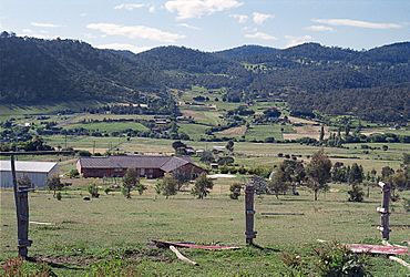
Magra area, looking north
|
|||||||||||||||
| Population | 699 (2016 census) | ||||||||||||||
| Postcode(s) | 7140 | ||||||||||||||
| Location |
|
||||||||||||||
| LGA(s) | Derwent Valley, Southern Midlands, Brighton | ||||||||||||||
| Region | Hobart, Central, South-east | ||||||||||||||
| State electorate(s) | Lyons | ||||||||||||||
| Federal Division(s) | Lyons | ||||||||||||||
|
|||||||||||||||
Magra is a small, quiet place in the countryside of Tasmania, Australia. It's mostly homes and farms. Magra is located a few kilometers north of New Norfolk in the beautiful Derwent Valley. In 2016, about 699 people lived here.
Contents
Discover Magra's Landscape
Magra is located just over the hill from the town of New Norfolk. The area is known for its pretty countryside. You'll find many houses and farms here.
Nature and Scenery
The landscape around Magra is quite lovely. It features rolling hills and a special group of tall trees called Lombardy Poplars. These trees add to the beauty of the area.
A Place for Visitors
Because of its natural beauty, Magra is a popular spot for tourists. There are places to stay if you want to visit and explore the countryside.
Betty King's Grave
Near Magra, you can find the grave of Betty King. She is believed to be the first European white woman to ever set foot on Australian soil. This makes her grave a very important historical site.
Magra's Past: A Brief History
Magra has an interesting history. It officially became known as a "locality" in 1970.
Name Change
Before 1912, Magra was called Black River. The name was changed to Magra around that time. It is thought that "Magra" is an Aboriginal word that means "day."
Stanton Farmhouse
One of the oldest buildings in Magra is Stanton Farmhouse. It was built way back in 1817 and is located on Back River Road. This old farmhouse gives us a peek into the past.
Post Office History
Magra even had its own Post Office. It opened on June 1, 1911, and served the community for many years before closing in 1968.
Getting Around Magra
If you're traveling to Magra, you might use Route C184. This road, also known as Black Hills Road, goes through the south-west part of the area.
 | Roy Wilkins |
 | John Lewis |
 | Linda Carol Brown |


