Maitai River facts for kids
Quick facts for kids Maitai River |
|
|---|---|
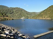
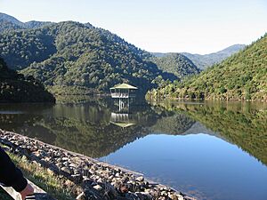
Water behind the dam on the river
|
|
| Country | New Zealand |
| Physical characteristics | |
| River mouth | Tasman Bay / Te Tai-o-Aorere |
| Length | 11 km (7 mi) |
| Basin features | |
| Basin size | 9000 Ha |
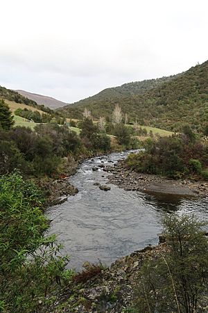
The Maitai River (also known as the Mahitahi River) is a super important river in Nelson, New Zealand. It's the biggest river in the area! This river starts high up in the Bryant Range mountains. It then flows west, right through the middle of Nelson city. Finally, it empties into Tasman Bay / Te Tai-o-Aorere, which is part of the Tasman Sea.
The Maitai River is like a busy highway for nature. Lots of different animals and plants call it home. Birds, fish, mammals, and reptiles all use the river. It gives them food, water, and a safe place to live. The river also helps many plants grow along its banks. Scientists have even found unique creatures here!
People love the Maitai River for fun activities. You can walk or bike along its trails. Many spots are perfect for swimming, especially on a hot day. The river is a great place for locals and tourists to relax and enjoy nature.
The river also helps Nelson city in big ways. A dam on the river creates a reservoir that stores water. This water is then used by everyone in Nelson for drinking and other needs. The river also acts like a giant drain. It helps control floods and carries away storm water from the city.
Contents
Discovering the Maitai River's Geography
The Maitai River is the longest river in the Nelson area. It flows for about 11 kilometers (7 miles). It starts in the Bryant Range and flows into the Tasman Sea. The Maitai River also has smaller rivers that join it. These smaller rivers are called tributaries. The two main ones are the Mineral Belt and the Roding.
As you go further upstream, away from the city, the river changes. It becomes surrounded by thick forests and rocky cliffs. Water from these areas flows into the river. Even further upstream, you'll find the Maitai Dam and Reservoir. This is the biggest man-made structure on the river. A thick layer of rock keeps the Maitai separate from other nearby rivers.
The river starts at its headwaters, high in the mountains. From there, it flows down through the Lowland Hill Country. This part of the river is mostly surrounded by forests. Then, it reaches the Lowland Flats and Alluvial Terraces. These are flatter areas, also covered in trees. Finally, it gets to the Coastal Flats, where the forest ends. The river then flows into the Tasman Sea at Nelson Haven. This area is an estuary, where fresh river water mixes with salty ocean water.
Amazing Wildlife of the Maitai River
The Maitai River is home to a huge variety of plants and animals. What you find depends on where you are along the river. Some creatures live in the water, while others live on the banks.
Animals Living in and Around the River
Animals that live near the Maitai River depend on it for survival. The river provides them with shelter, water, and food. This creates a special ecosystem. Where the river meets the sea, you'll find many estuary creatures. Fish and seabirds, like the Red Knot and oyster catchers, are common here. Crabs and other crustaceans also live in this salty area.
As you move upstream, the water becomes fresh. Here, you might spot rare birds like the Rifleman and Kakariki. They live in the forests next to the river. Reptiles like the Forest gecko and Northern grass skink also use the river's surroundings. Even tiny creatures like the Giant land snail live here.
The Maitai River is also home to unique fish. These include the inanga, longfin eel, and brown trout. Scientists have even discovered new types of water-beetles in the river! These beetles thrive in the river's special environment.
Plants and Their Life Cycle
The types of plants growing along the Maitai River depend on the land. The soil quality and minerals in the ground play a big role. Closer to the city, the river is lined with podocarp forests. As you go further east, the trees change. You'll see more beech vegetation because the soil is different.
Even further east, many small tributaries join the river. One of these, the Mineral Belt, has very unique soil. Only special plants can grow there. Some of these plants are rare and endangered. The lowland hill country around the river is also covered in plants. Here, you'll find beech, podocarp, and kamahi trees growing in abundance.
Fun Activities and Leisure on the Maitai River
The Maitai River is a popular spot for both locals and tourists. It's easy to get to from Nelson city. Many walking trails follow the river, starting in the city and heading east. These trails can take a few hours to complete. You can also cycle or run on these trails, even within the city limits.
Along the trails, you'll find many swimming holes. These are perfect spots to cool off in the river. There are many swimming options, both near the city and further upstream. Other fun things to do include fishing and water activities. The estuary area lets you explore the river and the sea.
Golf courses also use the river. It's a nice feature and provides water for the course. Camping and exploring are also popular. Places like the Maitai Valley Camp offer great spots to enjoy the river's beauty. Cycling and biking trails also follow the river's path. Sometimes, activities might be stopped if the river's water quality changes. This can happen if there's too much algae or an imbalance of minerals.
How the Maitai River Helps Nelson City
The Maitai River is super important for Nelson city's water supply. It provides a lot of the water that people use every day. The Maitai Water Supply Project helped increase how much water the river could store. This project built the Maitai Dam and Reservoir. These structures help store more than double the amount of water for the city.
The project also aimed to provide high-quality water. It only needed simple treatment like chlorination. Planning for this started in 1980 and took over four years to finish. The dam and reservoir were completed around mid-1986. Managing the water can be tricky because its temperature and quality can change. For example, the water can get warmer in summer. The council regularly checks the water quality. This ensures the water is safe for drinking and other uses.
The dam is located higher up the river. It creates the Maitai Reservoir, which can hold a huge amount of water. This reservoir is the main source of water for Nelson city. It's vital that it's kept clean and usable. The reservoir is very large, covering about 32 hectares. It's also very deep, holding almost 4 million cubic meters of water. The reservoir helps refill the dam when water levels are low. Water quality is always tested to make sure it's safe for everyone.
The Maitai River also acts as a flood channel. This means it helps protect Nelson city from floods. It guides floodwaters away from homes and buildings. It also works as a storm water drainage system. This helps manage the flow of water in the river and the city.
Forestry and tree plantations also use the Maitai River. The river provides water for these trees to grow. Pine tree plantations are common in the middle part of the river's area.
Friends of the Maitai: Protecting the River
The Friends of the Maitai (FOM) is a group that helps protect the river. They have been active for over 50 years. They speak up when issues might harm the river.
The first Friends of the Maitai group started in 1977. They tried to stop the Nelson City Council from planting pine trees on the Waahi Taakaro hillsides. They wanted native plants and more fun activities instead. Sadly, they lost that fight, and the group stopped in 1984.
Later, when the Maitai Dam was built in 1987, some people worried about how it would affect the river's flow. But the council promised to keep a minimum water level, so no group formed to fight it. More recently, people in Nelson East were upset about logging trucks using city streets. They won some changes, but trucks still go through the city.
Friends of the Maitai Today
The current Friends of the Maitai group started in 2014. Local residents met with the Nelson City Council to share ideas for planting trees along the river. Soon after, the Council put up signs about toxic algae. More residents joined the group, and they became the Friends of the Maitai.
The Council started a project called Project Maitai-Mahitahi. The FOM group helps with the community part of this project. They organize different interest groups:
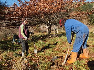
- Planting and plant care – They join Council planting days and hold their own. A big success is the Groom Creek Wetland. Thousands of shrubs, trees, and grasses have turned a bare area into a beautiful wetland.
- River monitoring – A group regularly checks water quality at sites in the Maitai Stream and Brook tributary. This "citizen science" data helps bigger research groups like NIWA and Cawthron Institute. In 2019, FOM got a grant to install a continuous river monitor. This helps get more reliable data.
- Forestry – Scientists have found that dirt from pine tree harvesting is the main problem affecting Maitai River water quality. This group works with the logging industry and the Council to improve practices. They hope to eventually replace pine forests with native trees.
- Communication – This group manages a website, Facebook page, and newsletters. They also talk to the Council and media about important river issues.
Representatives from these groups meet regularly to share information and plan activities. Friends of the Maitai is an informal group, and they welcome new members!
 | Toni Morrison |
 | Barack Obama |
 | Martin Luther King Jr. |
 | Ralph Bunche |


