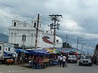
Malacatán facts for kids
Quick facts for kids
Malacatán
|
|
|---|---|
|
Municipality
|
|
| Country | |
| Department | |
| Area | |
| • Municipality | 89 sq mi (231 km2) |
| Population
(2019 census)
|
|
| • Municipality | 92,816 |
| • Density | 1,040.7/sq mi (401.8/km2) |
| • Urban | 8,689 |
| Climate | Am |
Malacatán is a town and municipality in the San Marcos department of Guatemala. It is located west of the main San Marcos town. The town is quite close to the border with Mexico, and you can cross into Mexico at the nearby village of El Carmen.
Contents
History of Malacatán
Early Days: Spanish Influence
After the Spanish conquest of Guatemala in the 1520s, a religious group called the Mercedarians became very active in the area. In 1565, they formed a special province called "Presentación de Guatemala."
The Mercedarians were a Catholic order. They were given control over several towns, including Malacatán. Their job was to teach the local people about Christianity and manage the communities. They often built churches and helped organize daily life.
By the early 17th century, the Mercedarians had influence over many towns. Records from 1613 and 1770 show that they managed nine main areas, including Santa Ana de Malacatán.
However, in 1754, the Spanish kings made some changes. These changes meant that the Mercedarians and other similar religious orders had to give up control of their towns to regular priests. This is how the Mercedarians lost their influence in places like Malacatán.
Sports in Malacatán
Malacatán has its own football (soccer) club called Deportivo Malacateco. This team played in Guatemala's top football league, the Liga Mayor, during the 2010/2011 season. They play their home games at the Estadio Santa Lucia stadium.
Climate and Weather
Malacatán has a tropical climate. This means it's generally warm all year round. It has a long rainy season that lasts from April to November. The dry season is shorter, happening during what people in other places might call "winter."
Even though the temperatures don't change much, April is usually the warmest month. October is typically the coolest month. The hottest part of the day is usually in the afternoon during February and March. The coolest afternoons are in September and October.
| Climate data for Malacatán | |||||||||||||
|---|---|---|---|---|---|---|---|---|---|---|---|---|---|
| Month | Jan | Feb | Mar | Apr | May | Jun | Jul | Aug | Sep | Oct | Nov | Dec | Year |
| Mean daily maximum °C (°F) | 32.4 (90.3) |
32.8 (91.0) |
33.6 (92.5) |
33.0 (91.4) |
32.4 (90.3) |
31.0 (87.8) |
31.6 (88.9) |
31.5 (88.7) |
31.1 (88.0) |
31.1 (88.0) |
31.5 (88.7) |
31.8 (89.2) |
32.0 (89.6) |
| Daily mean °C (°F) | 25.7 (78.3) |
26.1 (79.0) |
27.0 (80.6) |
27.2 (81.0) |
26.9 (80.4) |
26.0 (78.8) |
26.2 (79.2) |
26.3 (79.3) |
26.1 (79.0) |
25.0 (77.0) |
25.9 (78.6) |
25.7 (78.3) |
26.2 (79.1) |
| Mean daily minimum °C (°F) | 19.1 (66.4) |
19.4 (66.9) |
20.4 (68.7) |
21.4 (70.5) |
21.5 (70.7) |
21.0 (69.8) |
20.9 (69.6) |
21.1 (70.0) |
21.2 (70.2) |
21.0 (69.8) |
20.3 (68.5) |
19.6 (67.3) |
20.6 (69.0) |
| Average precipitation mm (inches) | 29 (1.1) |
36 (1.4) |
77 (3.0) |
222 (8.7) |
460 (18.1) |
644 (25.4) |
484 (19.1) |
591 (23.3) |
698 (27.5) |
563 (22.2) |
201 (7.9) |
57 (2.2) |
4,062 (159.9) |
| Source: Climate-Data.org | |||||||||||||
Where is Malacatán?
Malacatán is surrounded by other towns in the San Marcos Department. The only exception is its western side, which borders Chiapas, a state in México.
 |
Tajumulco Chiapas, state of México |
San Pablo |  |
|
| Chiapas, state of México | San Pablo and Catarina | |||
| Ayutla |
See also
 In Spanish: Malacatán para niños
 | Sharif Bey |
 | Hale Woodruff |
 | Richmond Barthé |
 | Purvis Young |


