Ayutla, San Marcos facts for kids
Quick facts for kids
Ayutla
|
|
|---|---|
|
Municipality
|
|

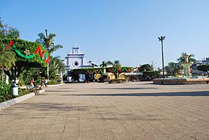
Main plaza and church in Ciudad Tecún Umán
|
|
| Country | |
| Department | |
| Municipal Seat | Ciudad Tecún Umán |
| Area | |
| • Municipality | 125 km2 (48 sq mi) |
| Population
(2018 census)
|
|
| • Municipality | 37,049 |
| • Density | 296.4/km2 (767.7/sq mi) |
| • Urban | 23,574 |
| Climate | Aw |
Ayutla (pronounced a-YOOT-lah) is a special kind of town called a municipality in Guatemala. It's located in the San Marcos Department. Ayutla sits right on the Suchiate River, which forms a natural border with Mexico. The main town in this area is called Ciudad Tecún Umán.
There's a cool bridge here called Puente Rodolfo Robles. This bridge lets both cars and trains cross from Ayutla into Ciudad Hidalgo in Chiapas, Mexico. A railway line in this area was even rebuilt in 2019 to help with transport.
About Ayutla
Ayutla is an important place because of its location. It helps connect Guatemala and Mexico.
What is a Municipality?
A municipality is like a local government area. It includes a main town and the smaller villages or rural areas around it. Ayutla is one such area, with Ciudad Tecún Umán as its center.
Weather in Ayutla
Ayutla has a tropical savanna climate. This means it's usually warm all year round. It has a wet season and a dry season. The wet season brings more rain, while the dry season is sunnier.
| Climate data for Ayutla | |||||||||||||
|---|---|---|---|---|---|---|---|---|---|---|---|---|---|
| Month | Jan | Feb | Mar | Apr | May | Jun | Jul | Aug | Sep | Oct | Nov | Dec | Year |
| Mean daily maximum °C (°F) | 34.5 (94.1) |
34.9 (94.8) |
35.9 (96.6) |
35.8 (96.4) |
35.2 (95.4) |
33.7 (92.7) |
34.2 (93.6) |
34.3 (93.7) |
33.8 (92.8) |
33.8 (92.8) |
33.8 (92.8) |
33.9 (93.0) |
34.5 (94.1) |
| Daily mean °C (°F) | 27.1 (80.8) |
27.4 (81.3) |
28.7 (83.7) |
29.3 (84.7) |
29.2 (84.6) |
28.3 (82.9) |
28.5 (83.3) |
28.5 (83.3) |
28.3 (82.9) |
28.3 (82.9) |
27.8 (82.0) |
27.2 (81.0) |
28.2 (82.8) |
| Mean daily minimum °C (°F) | 19.7 (67.5) |
20.0 (68.0) |
21.5 (70.7) |
22.8 (73.0) |
23.3 (73.9) |
22.9 (73.2) |
22.8 (73.0) |
22.7 (72.9) |
22.8 (73.0) |
22.8 (73.0) |
21.8 (71.2) |
20.5 (68.9) |
22.0 (71.5) |
| Average precipitation mm (inches) | 4 (0.2) |
1 (0.0) |
8 (0.3) |
53 (2.1) |
139 (5.5) |
293 (11.5) |
201 (7.9) |
205 (8.1) |
295 (11.6) |
225 (8.9) |
51 (2.0) |
6 (0.2) |
1,481 (58.3) |
| Source: Climate-Data.org | |||||||||||||
Where is Ayutla Located?
Ayutla is in the southwestern part of Guatemala. It shares borders with several other places:
- To the North: Malacatán and Catarina (both in San Marcos Department).
- To the East: Pajapita (San Marcos Department) and Coatepeque (Quetzaltenango Department).
- To the West: The state of Chiapas in México.
- To the South: Ocós (San Marcos Department).
 |
Malacatán and Catarina, municipalities of San Marcos Department |  |
||
| Chiapas, State of México | Pajapita, municipality of San Marcos Department and Coatepeque municipality of Quetzaltenango Department | |||
| Ocós, municipality of San Marcos Department. |
See also
 In Spanish: Ayutla Tecún Umán para niños
 | Bessie Coleman |
 | Spann Watson |
 | Jill E. Brown |
 | Sherman W. White |


