Malad River (Idaho-Utah) facts for kids
This page is about the river that flows past Malad City, Idaho and into the Bear River in Utah. For other uses, see Malad River.
Quick facts for kids Malad River |
|
|---|---|
|
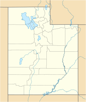
Location of the mouth of the Malad River in Utah
|
|
| Country | United States |
| State | Utah, Idaho |
| Counties | Box Elder County, Utah, Oneida County, Idaho |
| Physical characteristics | |
| Main source | Big Malad Spring northwest of Malad City, Oneida County, Idaho 4,728 ft (1,441 m) 42°13′18″N 112°21′54″W / 42.22167°N 112.36500°W |
| River mouth | Bear River south of Bear River City, Box Elder County, Utah 4,222 ft (1,287 m) 41°35′10″N 112°07′03″W / 41.58611°N 112.11750°W |
| Length | 97 mi (156 km) |
The Malad River is a river that flows through southeastern Idaho and northern Utah in the western United States. It's about 97 miles (156 km) long. This river is a branch, or tributary, of the larger Bear River.
Where the Malad River Flows
The Malad River begins in Idaho, northwest of a town called Malad City. From there, it flows south. It crosses the border into Utah near Portage, Utah. The river then continues its journey, passing through Tremonton. Finally, the Malad River joins the Bear River just south of Bear River City.
Why is it Called Malad River?
The name "Malad" comes from a French word, malade, which means "sick." Early pioneers exploring the area gave the river this name. They might have gotten sick after drinking its water. This shows how important clean water was, even in the past!
Black History Month on Kiddle
Prominent African-American Labor Activists
 | Isaac Myers |
 | D. Hamilton Jackson |
 | A. Philip Randolph |

All content from Kiddle encyclopedia articles (including the article images and facts) can be freely used under Attribution-ShareAlike license, unless stated otherwise. Cite this article:
Malad River (Idaho-Utah) Facts for Kids. Kiddle Encyclopedia.


