
Malakula facts for kids
 |
|

Map of Malakula
|
|
| Geography | |
|---|---|
| Location | Pacific Ocean |
| Coordinates | 16°15′S 167°30′E / 16.250°S 167.500°E |
| Archipelago | New Hebrides |
| Area | 2,041 km2 (788 sq mi) |
| Highest elevation | 879 m (2,884 ft) |
| Highest point | Mount Liambele |
| Administration | |
|
Vanuatu
|
|
| Province | Malampa |
| Largest settlement | Lakatoro |
| Demographics | |
| Population | 22,934 |
| Ethnic groups | Ni-Vanuatu |
Malakula Island, also known as Malekula, is the second-largest island in the country of Vanuatu. Vanuatu used to be called the New Hebrides. Malakula is located in Melanesia, a part of the Pacific Ocean.
Contents
Island Location and Features
Malakula is separated from the islands of Espiritu Santo and Malo by the Bougainville Strait. This is a narrow stretch of water.
Lakatoro is the main town on Malakula. It is the capital of Malampa Province. Lakatoro is found on Malakula's northeastern coast.
Close to Malakula's northeastern coast are several smaller islands. These are often called the Small Islands. They include Vao, Atchin, Wala, Rano, Norsup, Uripiv, and Uri. Other islands nearby are Tomman Island to the southwest, Akhamb Island to the south, and the Maskelynes Islands to the southeast. The Maskelynes include Sakao Island and Uluveo.
Malakula's highest point is Mount Liambele. It reaches 879 meters (2,884 feet) above sea level. In 1768, a French explorer named Louis Antoine de Bougainville sailed through the strait. This strait between Malakula and Santo was then named after him.
Island History
,_before_1880.jpg)

The Ni-Vanuatu people lived on Malakula for many centuries. They were there long before Europeans arrived. The first Europeans to see the island were part of a Spanish trip led by Pedro Fernández de Quirós in 1606.
Later, in 1774, Captain James Cook visited Malakula. He was on his second journey to the Pacific. In the late 18th century, both the British and the French started to settle the islands. Eventually, they shared control of the area. This shared rule was called a "condominium." The islands were known as the New Hebrides.
In 1914 and 1915, a British expert named John Layard lived on Malakula. He studied the local people and their customs. He took notes, recorded sounds, and took over 400 photographs. When he went back to Britain, he gave copies of his photos to the Museum of Archaeology and Anthropology at Cambridge.
People of Malakula
In 2009, about 23,000 people lived on Malakula.
Almost thirty different languages are spoken on the island. Two main groups of people live there. The Big Nambas live in the northern part of the island. The Small Nambas live in the central part of the southern area.
Until recently, some tribes on Malakula had a special custom. They would gently shape babies' heads to make them cone-shaped. This was done to change the shape of their heads permanently. Having a cone-shaped head was seen as a sign of higher social status.
Economy and Services

Most of Malakula's economy comes from farming. The island has many copra plantations. Copra is the dried meat of coconuts, used to make coconut oil. These plantations are mostly on the eastern coast, near Norsup and Lakatoro. The largest copra farm in all of Vanuatu is in Norsup.
Both Norsup and Lakatoro have modern services. They have telephones and electricity that runs 24 hours a day. Norsup is home to the main hospital for the province. Lakatoro has more shops than Norsup. It also has a market, a branch of the National Bank of Vanuatu, and an Air Vanuatu office. Lakatoro is also where the island's main port is located. It is the administrative center for Malampa province, which includes Malekula, Ambrym, and Paama islands.
Things to Do and See
The middle of Malakula is very mountainous and covered in forests. It is a great place for hiking and watching birds. There are also old sites hidden in the bush in northern Malakula. These were once places where cannibalism took place. However, most of the bones and skulls have been moved or buried.
The Maskelynes and the small islands along Malakula's east coast have sandy beaches. They also have beautiful coral reefs. These reefs are perfect for snorkeling and diving.
Getting Around Malakula
Air Travel
Malakula has three airports. They are located at Norsup (in the north), Lamap (in the southeast), and Southwest Bay. The Norsup airport has a paved runway. Air Vanuatu offers daily flights to Malakula.
Road Travel
Lakatoro is the main center for road transport on Malakula. You can find trucks there that act like taxis. These trucks travel along the northeast coast as far as Vao.
Images for kids
-
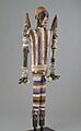
Effigy Figure (Rambaramp), before 1880. Wood, fiber, mud, pigment, bone, shell, boar's tusks. Brooklyn Museum
-
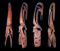
Canoe prow, Vao Island MHNT
-
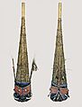
Malakula funeral masks – nineteenth century
See also
- In Spanish: Malakula para niños
