Malaspina Glacier facts for kids
Quick facts for kids Malaspina Glacier |
|
|---|---|

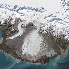
Malaspina Glacier captured by Landsat 8 on September 24, 2014
|
|
| Type | Piedmont |
| Location | Alaska |
| Coordinates | 59°55′09″N 140°31′58″W / 59.91917°N 140.53278°W |
| Area | 3,900 km2 (1,500 sq mi) |
| Length | 45 km (28 mi) |
| Thickness | 600 meters (2,000 ft) |
| Designated: | 1969 |

The Malaspina Glacier is a huge ice mass located in southeastern Alaska. It is the largest piedmont glacier on Earth. Imagine a giant, flat sheet of ice spreading out like a fan! This glacier is about 65 kilometers (40 miles) wide and 45 kilometers (28 miles) long. Its total area is around 3,900 square kilometers (1,500 square miles).
The glacier was named after Alessandro Malaspina. He was a Spanish explorer who visited the area in 1791. In 1874, W.H. Dall first called it the "Malaspina Plateau." He did not realize it was actually a glacier at the time.
Contents
What is a Piedmont Glacier?
A piedmont glacier forms when a valley glacier flows out of a mountain range. It then spreads out onto a wide, flat plain. The Malaspina Glacier is a perfect example of this. It looks like a giant, icy fan.
Where is the Malaspina Glacier?
The Malaspina Glacier is found in southeastern Alaska. It sits at the top of the Alaska Panhandle. It flows out from the Saint Elias Mountains onto the coastal plain. This plain faces the Gulf of Alaska. It is located between Icy Bay and Yakutat Bay.
Even though it fills the plain, the glacier does not reach the ocean. This means it is not a tidewater glacier. Tidewater glaciers flow directly into the sea.
How Does it Form?
The Malaspina Glacier is fed by several smaller valley glaciers. The main ones are the Seward Glacier and the Agassiz Glacier. These glaciers collect snow and ice in the mountains. Then, they slowly flow down and combine to form the massive Malaspina.
Size and Features
The Malaspina Glacier is incredibly thick in some places. It can be up to 600 meters (2,000 feet) deep. Scientists believe its bottom might even be 300 meters (1,000 feet) below sea level.
There are two lakes located near the edges of the glacier:
- Oily Lake is to the northwest. It is at the base of the Samovar Hills.
- Malaspina Lake is to the southeast. It is close to Yakutat Bay.
Changes Over Time
Scientists have used radar data and aerial photos to study the glacier. They found that the Malaspina-Seward glacier system lost about 20 meters (66 feet) of its thickness between 1980 and 2000. Because the glacier is so large, this amount of melting was enough to contribute a tiny bit to the rise in global sea levels. It added about 0.5% to the sea level rise during that period.
Protected Land
Most of the Malaspina Glacier is part of the Wrangell-St. Elias National Park and Preserve. This park is a protected area.
In October 1969, the glacier was also named a National Natural Landmark. This means it is a special natural place in the United States.
See also
 In Spanish: Glaciar Malaspina para niños
 | Madam C. J. Walker |
 | Janet Emerson Bashen |
 | Annie Turnbo Malone |
 | Maggie L. Walker |

