Icy Bay (Alaska) facts for kids
Quick facts for kids Icy Bay |
|
|---|---|

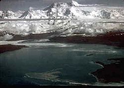
Glaciers at Icy Bay
|
|
| Location | Yakutat, Alaska |
| Coordinates | 59°59′24″N 141°23′25″W / 59.99000°N 141.39028°W |
| Type | Fjord |
| Native name | Lig̲aasi Áa (Tlingit) |
| Ocean/sea sources | Pacific Ocean |
Icy Bay (in the Tlingit language: Lig̲aasi Áa) is a special body of water located in Yakutat, Alaska. It's quite new, having formed mostly in the last 100 years. This happened because giant ice rivers called Glaciers, like the Guyot, Yahtse, and Tyndall Glaciers, have been melting and moving back very quickly.
At the start of the 1900s, a huge tidewater glacier blocked the entrance to what is now Icy Bay. This glacier was so big it dropped icebergs directly into the Gulf of Alaska. Over about a century, this glacier melted and retreated. This opened up the multi-armed bay we see today, which is more than 30 miles (48 km) long.
Icy Bay is a popular spot for people who love to sea kayak. You can reach this beautiful place by taking a small bush plane from Yakutat. It is also part of the Wrangell-Saint Elias Wilderness, a huge protected natural area.
Contents
The Giant Wave of 2015
On October 17, 2015, at 8:19 p.m. Alaska Daylight Time, something incredible happened. A huge part of a mountain broke off and slid down into Taan Fiord. Taan Fiord is a narrow arm of Icy Bay, created as the Tyndall Glacier melted away.
What Caused the Megatsunami?
This massive landslide created a "megatsunami" in Taan Fiord. A megatsunami is an extremely large wave, much bigger than a normal tsunami. The area where it happened is empty, so no one was there to see it. Scientists only found out about it hours later. They saw a strong signal on earthquake-measuring machines called seismograms in New York City.
Scientists visited the fiord in 2016 to study what happened. They learned that the landslide was made of about 200 million tons of rock. This huge amount of rock, about 76 million cubic yards, slid for 60 to 100 seconds. It reached speeds of up to 72 to 108 kilometers per hour (45 to 67 mph).
Some of the rock landed on the Tyndall Glacier. But about 180 million tons of rock, or 50 million cubic yards, crashed into the fiord. This impact also pushed away another 100 million cubic yards of material from the bottom of the fiord. Some of the landslide debris even crossed the 90-meter (300 ft) deep water. It then climbed 105 meters (344 ft) up the opposite shore. The landslide debris covered an area of about 2 square kilometers (0.77 sq mi).

How Big Was the Wave?
The landslide created a megatsunami that was initially about 100 meters (330 ft) tall! When it hit the opposite shore, it ran up the land to an amazing height of 193 meters (633 ft). This is called the run-up height. The wave then sped down the entire 15-kilometer (9.3 mi) length of the fiord. It moved at speeds of up to 60 miles per hour (97 kph) before reaching Icy Bay.
In the upper part of the fiord, the wave's run-up was over 100 meters (330 ft) high in some places. In other areas, it ranged from 70 to 100 meters (230 to 330 ft) on one side and 30 to 60 meters (98 to 200 ft) on the other. Further down the fiord, the wave heights varied a lot. In the lower fiord, the run-up was still 15 to 30 meters (49 to 98 ft) high.
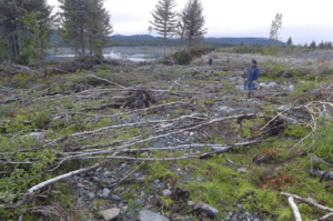
The wave covered an area of about 20 square kilometers (7.7 sq mi). It left a clear line where it stripped away all the trees and plants. This left behind bare beaches that reached elevations of 150 feet (46 m).
The Wave's Journey into Icy Bay
About 12 minutes after the landslide, the wave entered Icy Bay. It was still about 40 feet (12 m) tall. It flooded parts of the bay's coastline, with run-up levels of up to 4 to 5 meters (13 to 16 ft) in some spots. However, the wave got smaller the further it traveled into Icy Bay.
When the wave reached a tide gauge (a device that measures water levels) near Yakutat, it was only about 15 centimeters (5.9 in) tall. This tide gauge was 140 kilometers (87 mi) away from where the landslide happened.
Why Did This Happen?
The event in Taan Fiord was very similar to another huge landslide and megatsunami that happened in Alaska's Lituya Bay in 1958. The Taan Fiord landslide was the biggest recorded in North America since the eruption of Mount St. Helens in 1980. It was also the largest non-volcanic landslide ever recorded in North America.
The megatsunami in Taan Fiord was the largest known ocean tsunami worldwide since the Lituya Bay wave. Even though the Taan Fiord landslide was bigger than the one in Lituya Bay, the Lituya Bay wave was actually taller. This is because the Taan Fiord landslide didn't fall from as high up and landed in shallower water. The Taan Fiord wave was still the fourth-largest megatsunami of any kind in the last 100 years. It also had the fourth-highest run-up ever recorded anywhere in the world.
Scientists believe the landslide happened because the Tyndall Glacier had retreated about 17 kilometers (11 mi) between 1961 and 1991. This left the mountainside without the support of about 400 meters (1,300 ft) of glacial ice. Heavy rains might have also made the mountainside weaker. Plus, a small 4.1-magnitude earthquake happened about 500 kilometers (310 mi) away two minutes before the landslide. This earthquake's shaking might have also helped trigger the event.
 | Mary Eliza Mahoney |
 | Susie King Taylor |
 | Ida Gray |
 | Eliza Ann Grier |


