Manchester, Iowa facts for kids
Quick facts for kids
Manchester, Iowa
|
|
|---|---|
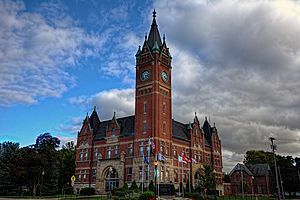
Delaware County Courthouse in Manchester
|
|
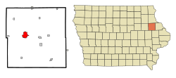
Location of Manchester, Iowa
|
|
| Country | United States |
| State | Iowa |
| County | Delaware |
| Incorporated | March 19, 1864 |
| Area | |
| • Total | 4.85 sq mi (12.57 km2) |
| • Land | 4.84 sq mi (12.53 km2) |
| • Water | 0.01 sq mi (0.04 km2) |
| Elevation | 942 ft (287 m) |
| Population
(2020)
|
|
| • Total | 5,065 |
| • Density | 1,046.92/sq mi (404.23/km2) |
| Time zone | UTC-6 (Central (CST)) |
| • Summer (DST) | UTC-5 (CDT) |
| ZIP code |
52057
|
| Area code(s) | 563 |
| FIPS code | 19-48810 |
| GNIS ID | 458752 |
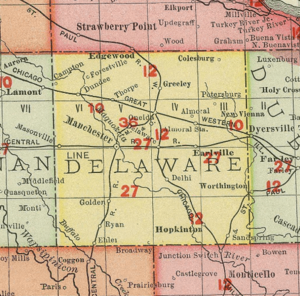
Manchester is a city in Delaware County, Iowa, United States. It is the main city and the county seat of Delaware County. This means it's where the county government offices are located.
Manchester is found where two important roads meet: U.S. Route 20 and State Highway 13. In 2020, about 5,065 people lived here. It's the biggest town in Delaware County and is famous for hosting the Delaware County Fair.
Contents
History of Manchester
Manchester was started in the 1850s. It was first named Burrington after its founder, Levings Burrington, who settled there in 1852. Later, the name was changed to Manchester.
Delaware County Courthouse
The county courthouse in Manchester was built in 1894. It cost $38,000, which was a lot of money back then! The clock in its tall tower was paid for by over 700 people from the county who all chipped in.
The building was designed by C.E. Bell and has a cool Romanesque Revival style. It's made of red bricks and has very thick walls, about 18 inches (45.7 cm) thick. The tower and spire reach 135 feet (41 meters) high. Inside, you can still see the original fancy metal ceilings and detailed wooden decorations. This historic building was added to the National Register of Historic Places in 1981.
Geography of Manchester
Manchester is located right next to the Maquoketa River. This river adds to the natural beauty of the area.
The city covers a total area of about 4.70 square miles (12.17 square kilometers). Most of this area, about 4.68 square miles (12.12 square kilometers), is land. Only a small part, about 0.02 square miles (0.05 square kilometers), is water.
Population of Manchester
| Historical population | ||
|---|---|---|
| Year | Pop. | ±% |
| 1870 | 1,492 | — |
| 1880 | 2,275 | +52.5% |
| 1890 | 2,344 | +3.0% |
| 1900 | 2,887 | +23.2% |
| 1910 | 2,758 | −4.5% |
| 1920 | 3,111 | +12.8% |
| 1930 | 3,413 | +9.7% |
| 1940 | 3,762 | +10.2% |
| 1950 | 3,987 | +6.0% |
| 1960 | 4,402 | +10.4% |
| 1970 | 4,641 | +5.4% |
| 1980 | 4,942 | +6.5% |
| 1990 | 5,137 | +3.9% |
| 2000 | 5,257 | +2.3% |
| 2010 | 5,179 | −1.5% |
| 2020 | 5,065 | −2.2% |
| Source: Source: |
||
Manchester's population has changed over the years. In 2020, the city had 5,065 people living there. This means there were about 1,047 people per square mile.
Most of the people living in Manchester are White (93.0%). There are also smaller groups of Black or African American (1.8%), Native American (0.5%), and Asian (0.5%) residents. About 2.2% of the population is Hispanic or Latino.
The average age of people in Manchester in 2020 was 43.9 years old. About 24% of the residents were under 20 years old.
Economy in Manchester
Manchester is important to Delaware County because it's the county seat. This means many people work for the county government here.
Some of the biggest employers in Manchester include XL Specialized Trailers, Henderson Products, Regional Medical Center, and the West Delaware Community School District. There are also many other small businesses in the area. Farming, or agriculture, is a very important part of the local economy.
Manchester is also conveniently located near three of Iowa's larger cities: Cedar Rapids, Waterloo, and Dubuque. They are all within about 45 miles (72 kilometers).
Parks and Recreation in Manchester
Manchester has many fun places for outdoor activities!
Whitewater Park
In 2015, Manchester opened a cool Whitewater Park. It's built on a part of the Maquoketa River that flows through the downtown area. This park is about 900 feet (274 meters) long and has six drops, each about 18 inches (46 cm) high, perfect for kayaking and other water sports.
Skate Park
A concrete Skate Park was built in 2013. You can find it at Central Park, ready for skateboards and scooters.
Manchester Trout Hatchery
Manchester is home to the Manchester Trout Hatchery, which has been around since the 1890s. This is where trout fish are raised. It's also the regional office for the Iowa Department of Natural Resources (DNR) for fishing, wildlife, and law enforcement.
Parks and Natural Areas
Delaware County, where Manchester is located, has over 35 parks covering more than 2,000 acres (809 hectares). One of the most special places is Backbone State Park, which was Iowa's very first state park. It's known for its unique geography and beautiful scenery.
Manchester Family Aquatic Center
For swimming and splashing fun, Manchester has the Family Aquatic Center. It features three water slides, a diving board, a shallow entry area, spray fountains, sand volleyball, and a snack bar.
Education in Manchester
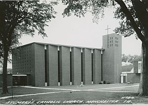
Manchester is part of the West Delaware County Community School District. This district includes West Delaware High School, West Delaware Middle School, and Lambert Elementary. The school mascot is the Hawks! There is also St. Mary's Catholic School, which teaches students from preschool to 6th grade.
West Delaware High School received a special award in 2012. The United States Department of Education named it a National Blue Ribbon School. This award is given for excellent academic performance, and only two high schools in Iowa received it that year!
Lambert Elementary and Middle School were also recognized in 2014 as a HealthierUS Bronze School, which is another national award for promoting health and wellness.
Notable People from Manchester
- Robert Gallery – A former professional football player in the NFL. He was a first-round draft pick for the Oakland Raiders.
- Elizabeth Wilson – She was a member of the Iowa House of Representatives, helping to make laws for the state.
See also
 In Spanish: Mánchester (Iowa) para niños


