
Manhasset Bay facts for kids

Manhasset Bay is a beautiful bay in New York. It is located on the western side of Long Island, right off Long Island Sound. This bay helps form the edges of two important areas: the Great Neck Peninsula and Cow Neck. Cow Neck is also known as the Port Washington Peninsula or Manhasset Neck.
The bay has several interesting points of land. On its north side, you'll find Barkers Point near the entrance. Plum Point reaches furthest into the bay, and Tom's Point is located in the back. On the other side, Hewlett Point marks the entrance, almost a mile from Barkers Point. Just outside the bay's mouth, in the Sound, lies Hart Island.
Discovering Manhasset Bay's Past
Long ago, in the 1600s, the land around Manhasset Bay was home to the Matinecook tribe. They were part of the Algonquin Indians. Later in the 17th century, settlers from the Dutch and English arrived. They were drawn to the bay because there was a lot of fish there.
The bay had different names over time. The Dutch called it Schout's Bay. Then the English named it Howe's Bay. Because many cows were raised nearby, it later became known as Cow Bay. The land next to it was called "Cow Neck." Finally, in 1907, the bay officially received its current name: Manhasset Bay.
How Manhasset Bay Changed Over Time
In the 1920s, Manhasset Bay started to change. It moved away from just fishing and raising cows. Instead, it became a hub for boats and boating services. The bay is known as one of the best harbors on Long Island Sound. This is because it has very little tidal current, except near its entrance. The water level usually changes by only about six feet.
By the 1980s, the bay was filled with many marinas and yacht clubs. These are places where boats are docked and cared for. The Sands Point Seaplane Base was once located on Manhasset Bay. It was a major airport for people traveling by seaplane between New York and Europe. By the early 2000s, Manhasset Bay was home to about 16% of all the marinas and yacht clubs on the entire Long Island Sound.
Images for kids
-
A beautiful sunset view of Manhasset Bay from the west side, with someone fishing.
-
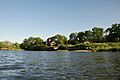
The east side of Manhasset Bay, near Leeds Pond.
-
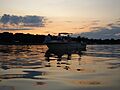
A boat moored in Manhasset Bay at sunset.
-

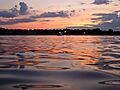
Another view of a boat moored in Manhasset Bay as the sun sets.
-
A wide view of Manhasset Bay from an estate across Leeds Pond.
-
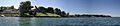
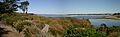
A panoramic view of Manhasset Bay.


