
Manley Hot Springs, Alaska facts for kids
Quick facts for kids
Manley Hot Springs
Too Naaleł Denh
|
|
|---|---|

Manley Hot Springs welcome sign
|
|

Location of Manley Hot Springs, Alaska
|
|
| Country | United States |
| State | Alaska |
| Census Area | Yukon-Koyukuk |
| Area | |
| • Total | 54.61 sq mi (141.44 km2) |
| • Land | 54.61 sq mi (141.44 km2) |
| • Water | 0.00 sq mi (0.00 km2) |
| Population
(2020)
|
|
| • Total | 169 |
| • Density | 3.09/sq mi (1.19/km2) |
| Time zone | UTC-9 (Alaska (AKST)) |
| • Summer (DST) | UTC-8 (AKDT) |
| ZIP code |
99756
|
| Area code | 907 |
| FIPS code | 02-46780 |
Manley Hot Springs is a small community in Alaska, United States. Its name in the Koyukon is Too Naaleł Denh. It is a "census-designated place" (CDP), which means it's an area identified by the government for statistics, but it doesn't have its own local government like a city. In 2020, about 169 people lived there. This was a big jump from 89 people in 2010!
Contents
Where is Manley Hot Springs Located?
Manley Hot Springs is found in the Yukon-Koyukuk Census Area of Alaska. It's about 8 kilometers (5 miles) north of the Tanana River. You can reach it by driving to the very end of the Elliott Highway. This highway is about 260 kilometers (160 miles) west of Fairbanks, a larger city. The total land area of Manley Hot Springs is around 141 square kilometers (54 square miles).
A Look Back at Manley Hot Springs' History
The land around Manley Hot Springs has traditionally belonged to the Cosna Band of the Upper Koyukon Dene people for a very long time.
How Manley Hot Springs Began
In 1902, a person looking for valuable minerals, named John Karshner, found several hot springs in this area. He decided to start a farm there, growing vegetables. Around the same time, the United States Army built a telegraph station. This made the area important for miners working nearby. It was first called Baker's Hot Springs.
Growth and the Famous Resort
Farms in the area grew fresh food and raised animals. This helped feed the growing number of people. In 1903, a place called Sam's Rooms and Meals opened. Today, it's known as the Manley Roadhouse and is still the only restaurant and hotel in the community.
In 1907, a miner named Frank Manley built a huge hotel called the Hot Springs Resort Hotel. It was a fancy four-story building with 45 rooms. It had modern features like steam heat and electric lights. Guests could enjoy hot baths, a bar, a restaurant, a billiard room, a bowling alley, and even an indoor swimming pool! The pool used the natural hot spring water. In summer, guests arrived by boat on the Tanana River. In winter, they took a two-day stagecoach trip from Fairbanks. Because of this amazing resort, the town was renamed Hot Springs.
Challenges and Changes Over Time
The resort and the mining industry helped the town grow. It had many businesses, including a store, a newspaper, and a bakery. By 1910, over 500 people lived there. However, in 1913, the big resort hotel burned down. Mining also started to slow down. By 1920, only 29 people lived in Hot Springs.
In 1957, the town's name was officially changed to Manley Hot Springs.
In May 2022, the community faced a big flood. This flood caused power outages and forced about 60 people to leave their homes. Luckily, no one was hurt. The flood happened because a large amount of ice blocked the Tanana River.
Weather in Manley Hot Springs
Manley Hot Springs has a very cold climate, known as a continental subarctic climate. This means it has long, very cold winters and short, cool summers.
| Climate data for Manley Hot Springs 15NE, Alaska, 1991–2020 normals, 1909–2014 extremes: 501ft (153m) | |||||||||||||
|---|---|---|---|---|---|---|---|---|---|---|---|---|---|
| Month | Jan | Feb | Mar | Apr | May | Jun | Jul | Aug | Sep | Oct | Nov | Dec | Year |
| Record high °F (°C) | 47 (8) |
45 (7) |
54 (12) |
72 (22) |
87 (31) |
93 (34) |
92 (33) |
89 (32) |
76 (24) |
64 (18) |
45 (7) |
41 (5) |
93 (34) |
| Mean daily maximum °F (°C) | 1.7 (−16.8) |
12.4 (−10.9) |
24.2 (−4.3) |
42.5 (5.8) |
60.6 (15.9) |
72.6 (22.6) |
72.3 (22.4) |
65.8 (18.8) |
53.5 (11.9) |
32.9 (0.5) |
10.9 (−11.7) |
3.3 (−15.9) |
37.7 (3.2) |
| Daily mean °F (°C) | −9.9 (−23.3) |
−1.6 (−18.7) |
6.6 (−14.1) |
27.7 (−2.4) |
45.4 (7.4) |
56.5 (13.6) |
59.2 (15.1) |
53.3 (11.8) |
41.1 (5.1) |
23.4 (−4.8) |
0.6 (−17.4) |
−6.0 (−21.1) |
24.7 (−4.1) |
| Mean daily minimum °F (°C) | −21.5 (−29.7) |
−15.6 (−26.4) |
−11.1 (−23.9) |
12.9 (−10.6) |
30.3 (−0.9) |
40.4 (4.7) |
46.0 (7.8) |
40.8 (4.9) |
28.6 (−1.9) |
13.8 (−10.1) |
−9.6 (−23.1) |
−15.3 (−26.3) |
11.6 (−11.3) |
| Record low °F (°C) | −77.1 (−60.6) |
−62 (−52) |
−59 (−51) |
−37 (−38) |
4 (−16) |
11 (−12) |
29 (−2) |
19 (−7) |
−10 (−23) |
−30 (−34) |
−54 (−48) |
−64 (−53) |
−77.1 (−60.6) |
| Average precipitation inches (mm) | 0.92 (23) |
0.92 (23) |
0.94 (24) |
0.56 (14) |
0.67 (17) |
1.77 (45) |
2.61 (66) |
2.63 (67) |
1.63 (41) |
1.10 (28) |
0.88 (22) |
1.06 (27) |
15.69 (397) |
| Average snowfall inches (cm) | 9.7 (25) |
7.5 (19) |
7 (18) |
3.3 (8.4) |
0.4 (1.0) |
0 (0) |
0 (0) |
0 (0) |
0.6 (1.5) |
6.9 (18) |
10.8 (27) |
11.3 (29) |
57.4 (146) |
| Average precipitation days (≥ 0.01 in) | 6 | 5 | 5 | 4 | 5 | 9 | 12 | 13 | 10 | 8 | 8 | 8 | 93 |
| Source 1: NOAA (1981-2010 precipitation) | |||||||||||||
| Source 2: WRCC (records, snowfall & precip days) | |||||||||||||
Population and People
| Historical population | |||
|---|---|---|---|
| Census | Pop. | %± | |
| 1910 | 101 | — | |
| 1920 | 29 | −71.3% | |
| 1930 | 45 | 55.2% | |
| 1940 | 39 | −13.3% | |
| 1950 | 29 | −25.6% | |
| 1960 | 72 | 148.3% | |
| 1970 | 34 | −52.8% | |
| 1980 | 61 | 79.4% | |
| 1990 | 96 | 57.4% | |
| 2000 | 72 | −25.0% | |
| 2010 | 89 | 23.6% | |
| 2020 | 169 | 89.9% | |
| U.S. Decennial Census | |||
Manley Hot Springs first appeared in the U.S. Census in 1910. Back then, it was called "Hot Springs." In 1957, its name officially changed to Manley Hot Springs. It became a census-designated place (CDP) in 1980.
In 2000, there were 72 people living in Manley Hot Springs. About 73% of the people were White, and about 23% were Native American. The average age of people living there was 44 years old.
Education in Manley Hot Springs
The Yukon–Koyukuk School District is in charge of the schools in the area. They operate the Gladys Dart School right in Manley Hot Springs.
Getting Around Manley Hot Springs

The Elliott Highway (Alaska Route 2) connects Manley Hot Springs to Fairbanks. This road was finished in 1959. Before 1982, the state didn't clear snow from the road, so it was closed in winter. Now, you can drive there all year round.
Manley Hot Springs also has an airport. The Manley Hot Springs Airport offers flights to Fairbanks International Airport. These flights are operated by Warbelow's Air Ventures.
Images for kids
-
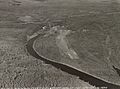
Manley Hot Springs in the 1930s
-
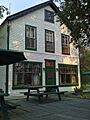
The Manley Roadhouse was built in 1903 and is still used today.
.jpg)

See also
 In Spanish: Manley Hot Springs para niños
