Manning, Oregon facts for kids
Quick facts for kids
Manning
|
|
|---|---|

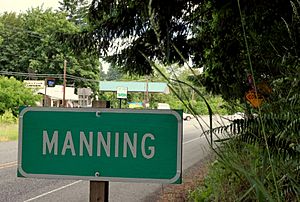
Sign and highway in Manning
|
|
| Country | United States |
| State | Oregon |
| County | Washington |
| Time zone | UTC-8 (Pacific (PST)) |
| • Summer (DST) | UTC-7 (PDT) |
| ZIP code |
97125
|
| Area code(s) | 503 and 971 |
Manning is a small, unincorporated community located in Washington County, Oregon, in the United States. It sits right along the Sunset Highway, which is also known as U.S. Route 26 and Oregon Route 47.
A popular path for biking and walking, the Banks–Vernonia State Trail, goes through Manning. You can even catch a bus here. The NorthWest POINT offers daily bus service between Portland and Astoria, with a stop in Manning.
Discovering Manning
The Story of Manning
Manning got its name from a person named Martin Manning. He settled here in 1865, claiming land to live and work on.
Later, in 1890, a post office was opened in Manning. This made it easier for people to send and receive mail.
In 1954, Manning joined with two nearby communities, Buxton and Banks. They formed a group called the Tri-City Rural Fire Protection District. This group helped protect their homes and land from fires. Today, it is known as the Banks Fire District.
The school in Manning, which was part of the Banks School District, closed its doors in 1987.
Famous Faces from Manning
Even small communities can have notable people! One person connected to Manning is Hollie Pihl.


