Mansfield, Georgia facts for kids
Quick facts for kids
Mansfield, Georgia
|
|
|---|---|

Mansfield, Georgia
|
|

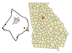
Location in Newton County and the state of Georgia
|
|
| Country | United States |
| State | Georgia |
| County | Newton |
| Area | |
| • Total | 1.10 sq mi (2.84 km2) |
| • Land | 1.09 sq mi (2.83 km2) |
| • Water | 0.01 sq mi (0.01 km2) |
| Elevation | 761 ft (232 m) |
| Population
(2020)
|
|
| • Total | 442 |
| • Density | 404.39/sq mi (156.17/km2) |
| Time zone | UTC-5 (Eastern (EST)) |
| • Summer (DST) | UTC-4 (EDT) |
| ZIP code |
30055
|
| FIPS code | 13-49616 |
| GNIS feature ID | 0317666 |
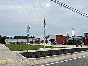
Mansfield is a small city located in Newton County, Georgia, in the United States. It's a quiet place where people live and work. In 2020, a count of all the people living there, called a census, showed that 442 people called Mansfield home.
Contents
History of Mansfield
Mansfield has had a few different names over the years. Before it was called Mansfield, it was known as "Bob Lee" and "Carmel." The name "Mansfield" became official when a post office opened there in 1897.
When Mansfield Became a Town
The Georgia General Assembly, which is like the state's law-making group, officially made Mansfield a town in 1903. This meant it could have its own local government and make decisions for its residents.
Geography of Mansfield
Mansfield is located in a specific spot on the map. Its coordinates are about 33.518669 degrees North and 83.735405 degrees West. These numbers help pinpoint its exact location on Earth.
How Big is Mansfield?
According to the United States Census Bureau, the city covers a total area of about 1.1 square miles (which is about 2.8 square kilometers). Most of this area is land. Only a very small part, less than 1%, is water.
People of Mansfield: Demographics
The word "demographics" means studying the population of a place. This includes how many people live there and other facts about them.
Population Changes Over Time
The number of people living in Mansfield has changed over many years. Here's how the population has grown and shrunk since 1910:
| Historical population | |||
|---|---|---|---|
| Census | Pop. | %± | |
| 1910 | 589 | — | |
| 1920 | 618 | 4.9% | |
| 1930 | 469 | −24.1% | |
| 1940 | 432 | −7.9% | |
| 1950 | 446 | 3.2% | |
| 1960 | 394 | −11.7% | |
| 1970 | 340 | −13.7% | |
| 1980 | 435 | 27.9% | |
| 1990 | 341 | −21.6% | |
| 2000 | 392 | 15.0% | |
| 2010 | 410 | 4.6% | |
| 2020 | 442 | 7.8% | |
| U.S. Decennial Census | |||
In the year 2000, a census showed that 392 people lived in Mansfield. These people lived in 132 different homes, and 105 of those homes were families. By the year 2020, the population had grown a bit to 442 people.
See also
 In Spanish: Mansfield (Georgia) para niños
 | James Van Der Zee |
 | Alma Thomas |
 | Ellis Wilson |
 | Margaret Taylor-Burroughs |

