
Manta, Cundinamarca facts for kids
Quick facts for kids
Manta
|
|||
|---|---|---|---|
.jpg)
Interior of the San Joaquín church of Manta
|
|||
|
|||
| Motto(s):
Retazo de cielo (Sky piece)
|
|||

Location of the town and municipality of Manta in Cundinamarca Department
|
|||

Manta
Location in Colombia
|
|||
| Country | |||
| Region | Andean Region | ||
| Department | |||
| Province | Almeidas Province | ||
| Founded | 24 July 1773 | ||
| Founded by | José Joaquín Pompeya | ||
| Area | |||
| • Municipality | 105 km2 (41 sq mi) | ||
| Elevation | 1,924 m (6,312 ft) | ||
| Population
(2015)
|
|||
| • Municipality | 4,719 | ||
| • Urban | 1,285 | ||
| Website | Official website: http://www.manta-cundinamarca.gov.co/ | ||
.jpg)

Manta is a town and municipality in Colombia. It is located in the northeast part of the Cundinamarca Department, about 90 kilometers (56 miles) from Bogotá, the capital city. Manta is part of the Almeidas Province and lies in the Tenza Valley.
The town shares its borders with several other places. To the north, it borders Tibiritá. To the west, it borders Machetá. To the south, it borders Gachetá. To the east, Manta borders Guateque and Guayatá, which are in the Boyacá department.
Contents
What Does the Name Manta Mean?
The name Manta comes from the Chibcha language of the Muisca people. The Muisca were the original people who lived in this area. In their language, "Manta" means "to your tillage" or "your farmfields." This name shows how important farming was to the ancient people here.
Another Muisca name still used today is Fuchatoque. This is the name of a vereda (a rural area or hamlet) located on the eastern side of the town center. It was once the home of an important Muisca leader called a cacique.
A Look Back: Manta's History
Early Days and Spanish Arrival
The first people to live in Manta were the indigenous Muisca. They settled here long ago, even before the Spanish arrived. Their homes were around the area where the town center is now. This place used to be a small lake.
According to an old Muisca story, there was an island in the middle of this lake. On this island, people saw an image of San Joaquín. This name is now used for the Catholic church in Manta.
Before the Spanish conquistadors came, Manta was part of the large area controlled by the Muisca Confederation. After the Spanish arrived, many Muisca people moved to the nearby town of Tibiritá. The Spanish and mestizos (people of mixed European and indigenous heritage) stayed and helped form the modern town of Manta.
Manta was officially founded on July 24, 1773. The main founder was José Joaquín Pompeya. Another important founder was Juan José Bernal Ramírez. To set the town's borders, an area called "Manta Grande" was combined with a piece of land from the old municipality of Guateque.
Manta in Modern Times
In the late 1800s, Colombia faced political disagreements. Manta was involved in some of these events. For example, General Daniel Aldana, who was from Manta, was a leader in Cundinamarca. He tried to support a revolution, but it didn't work out.
Later, in the early 1900s, Manta experienced some political violence, like many other parts of Colombia. There were conflicts between different political groups. You can still see some old trenches in the roads from that time.
Manta is also known as one of the possible birthplaces of Jorge Eliécer Gaitán, a very famous Colombian politician.
Manta's Natural Beauty: Geography
Manta is located on the eastern side of the Andes mountains in Colombia. The land here is very mountainous and uneven. There is only one flat area, which is where the main town is built. The elevation in Manta changes a lot, from about 1,500 meters (4,921 feet) to 3,400 meters (11,155 feet) above sea level. The highest point is the hill of La Laguna, also called La Petaca, which is 3,400 meters high.
The town sits in a valley formed by the Aguacia River. This river divides the area into two parts. The Aguacia River and the Machetá River join together in the north to form the Sunuba River. The Sunuba River then flows into the La Esmeralda water reservoir in Chivor.
High up in the mountains, there is a lake called Laguna del Cerro (Lake of the Hill). This lake has been made a nature reserve to protect the area. Many small streams and creeks flow down the mountains and into the Aguacia River. One of these streams forms a beautiful waterfall called El Golpe (The Strike).
Weather in Manta
Manta's weather is special because it's influenced by winds from the Llanos Orientales (Eastern Plains) of Colombia. This means the climate is usually very pleasant for most of the year. The average temperature is between 18 and 23°C (64 and 73°F). It's a dry equatorial climate, typical for a high mountain forest, also known as a cloud forest.
Even when other parts of Colombia are affected by El Niño (which brings dry weather) or La Niña (which brings heavy rains), Manta tends to stay drier compared to the Bogotá savanna region.
The rainy season in Manta usually runs from mid-April to mid-November. The driest months are December and January. The coldest temperature ever recorded in the town center was 11°C (51.8°F), and the warmest was 28°C (82.4°F).
Who Lives in Manta?
Most of the people living in Manta today are descendants of the early Spanish settlers and the Muisca people. The population has become smaller since the 1960s. This is because many people moved to bigger cities like Bogotá to find work or study.
However, Manta is now a popular place for vacations and relaxation. Many people who have family ties to the town come back to visit. This means the number of people in Manta can change a lot throughout the year. During holidays, weekends, and vacation seasons, the population can jump from about 4,500 regular residents to between 10,000 and 16,000 people, not counting tourists.
Fun Things to Do in Manta: Tourism
In recent years, Manta has become a great place to escape the busy life of big cities. There are several natural spots that visitors love:
- The Quebrada El Golpe (El Golpe Creek)
- The Laguna de la Petaca (Petaca Lake)
- The Cerro de la Petaca (Petaca Hill)
The Laguna del Cerro (Lake of the Hill), also known as Laguna de la Petaca, is located about 3,200 meters (10,499 feet) above sea level. It is a nature reserve, along with the native forest next to it. The town manages this reserve, and there are special trips organized every year in the first week of January for people to visit.
Manta also has good facilities for sports and fun activities. These include a stadium, a sports center, and a municipal swimming pool.
Images for kids
-
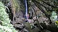
Quebrada El Golpe
-
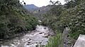
Aguacia River


See also
 In Spanish: Manta (Colombia) para niños
