Manuae (Cook Islands) facts for kids

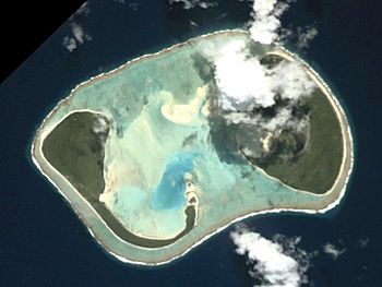
An aerial view of Manuae
|
|
 |
|
| Geography | |
|---|---|
| Area | 6.17 km2 (2.38 sq mi) |
| Highest elevation | 5 m (16 ft) |
| Administration | |
| Demographics | |
| Population | 0 (2021) |
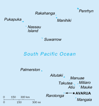
Manuae is a special island in the Cook Islands. It is an atoll, which means it's a ring-shaped coral island with a lagoon in the middle. Manuae is located in the southern part of the Cook Islands. It is about 100 kilometers (62 miles) southeast of another island called Aitutaki. Even though it's close to Aitutaki, Manuae is managed separately. No one lives on Manuae today.
Contents
About Manuae's Geography
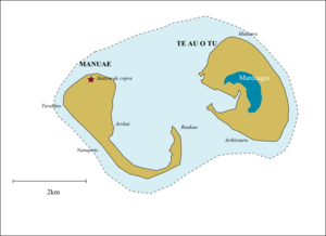
Manuae is a true atoll. It sits on top of a very tall underwater volcano. This volcano goes down more than 4,000 meters (13,000 feet) to the ocean floor! The atoll has two main parts, which are like two horseshoe-shaped islands. The western island is called Manuae islet, and the eastern one is Te Au O Tu islet.
Together, these two islands cover about 6 square kilometers (2.3 square miles). In the middle is a large lagoon, which is about 7 kilometers (4.3 miles) long and 4 kilometers (2.5 miles) wide. The lagoon is shallow and has many sand banks that move around. A coral reef surrounds the whole atoll, and there isn't a big opening through it for boats.
The ocean around Manuae is a special marine park. This means it's a protected area. It's a very important place for seabirds and sea turtles to lay their eggs and raise their young. Many fish also live in the waters near Manuae, making it a good spot for fishing.
Manuae's Past
People have known about Manuae for a very long time. Old stories say that a person named Ruatapu discovered the island. He called it Manu-enua, which means "bird-land." Ruatapu planted coconut trees and let birds go free there. Later, he sent his second son and his family to live on the island. Another story says that two brothers from Atiu island were the first to settle Manuae.
The famous explorer James Cook saw Manuae on September 23, 1773, during his second trip around the world. He didn't land then. He came back on April 6, 1777, during his third trip. This time, he found people living on the island. They seemed to be led by a chief from Atiu. Captain Cook first named the island "Sandwich Island." But he later changed it to "Hervey Island" to honor a friend. This name eventually became "Hervey's Island" and was even used for all the southern Cook Islands for a while.
In July 1823, John Williams from the London Missionary Society visited the island. He found about sixty people living there. However, the island became empty soon after. By 1852, only one family lived on Manuae. In 1888, the island became a British protectorate, which meant it was protected by Britain. Then, in 1900, New Zealand took control of it. Around 1898, the island was rented out to grow copra, which is dried coconut meat used to make oil.
In 1965, many people visited Manuae. Six different groups from countries like Australia, Japan, and the U.S.A. came to watch a total solar eclipse on May 30, 1965. This made the island's population briefly grow to over a hundred people.
In April 2020, the Cook Islands National Environment Service looked for two people to live on Manuae for a year. Their job was to take care of the island.
The Proprietors of Manuae Incorporated (PMI) is a group formed in 1983. Its members are chosen by the people who own the land on Manuae Atoll. In 2022, the PMI started a new group called the Manuae Enua Conservation Trust (MECT). This trust helps manage Manuae island for conservation and to make sure it's used in a way that protects its natural beauty.
Island Life and Facilities
Manuae once had a small industry based on copra. People lived near a small opening in the reef. This opening was less than 4 meters (13 feet) wide. It could be very dangerous to enter without knowing the local waters.
The island also has an old airfield. It's a coral airstrip that is now overgrown and hasn't been used for many years. Fishermen from Aitutaki sometimes travel to Manuae for fishing trips.
Population Changes
The most people recorded living on Manuae at one time was 32, during a census in 1956. But twenty years later, by 1976, the island was completely empty.
| Historical population | ||||||||||||||||||||||||||||
|---|---|---|---|---|---|---|---|---|---|---|---|---|---|---|---|---|---|---|---|---|---|---|---|---|---|---|---|---|
|
|
|||||||||||||||||||||||||||
| Papers Past | ||||||||||||||||||||||||||||
See also
 In Spanish: Manuae (Islas Cook) para niños
 | Mary Eliza Mahoney |
 | Susie King Taylor |
 | Ida Gray |
 | Eliza Ann Grier |


