
Aitutaki facts for kids

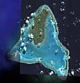
NASA picture of Aitutaki
|
|
| Geography | |
|---|---|
| Location | Central-Southern Pacific Ocean |
| Coordinates | 18°51′S 159°47′W / 18.85°S 159.79°W |
| Archipelago | Cook Islands |
| Total islands | 15 |
| Area | 18.3 km2 (7.1 sq mi) |
| Administration | |
| Largest settlement | Arutanga |
| Demographics | |
| Population | 1,712 |
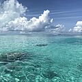
Aitutaki, also called Araʻura or Utataki, is a beautiful island in the Cook Islands. It's the second most populated island there, right after Rarotonga. Aitutaki is like a special kind of island called an "almost atoll." It has a main island and fifteen smaller islands, called islets, all inside a big, clear lagoon. The total land area is about 18 square kilometers. The lagoon itself is much bigger, covering between 50 and 74 square kilometers. Aitutaki is a very popular place for tourists to visit, making it the second most visited island in the Cook Islands.
In 2016, about 1,712 people lived on Aitutaki. The main village on the island is Arutanga, which is located on the west side.
Contents
What is Aitutaki's Geography Like?

Aitutaki is often called an "almost atoll" because it has a large lagoon surrounded by a reef, but also a significant area of high land. The highest point on the island is a hill called Maunga Pu, which is about 123 meters tall. The main island itself covers about 16.8 square kilometers. The Ootu Peninsula, which sticks out from the main island, adds another 1.75 square kilometers. The lagoon is quite large, covering between 50 and 74 square kilometers.
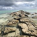
The reef that forms Aitutaki is shaped like a triangle, with each side being about 12 kilometers long. The southern part of this triangle is mostly underwater. The eastern side has a line of small islands, including Mangere, Akaiami, and Tekopua.
The western side of Aitutaki has important features. There's a boat passage through the reef that lets boats reach the shore near Arutanga. Further south, a small break in the reef allows smaller boats into the lagoon. The main island is mostly on the northern part of this side. Its rich volcanic soil helps grow tropical fruits and vegetables. Out of Aitutaki's 15 small islands (called motus), two are volcanic, and the rest are made of coral.
Aitutaki Airport is located near the northern tip of the island. In the past, the southeastern part of the lagoon near Akaiami was used as a landing spot for large flying boats.
What is Aitutaki's History?

The first people to settle on Aitutaki were Polynesians, arriving between AD 1225 and 1430. They traveled widely, as tools found here have materials from Samoa and the Society Islands. Local stories say the island was named by Te Erui, who raised it from the ocean. Other stories mention settlers like Ru and Ruatapu.
The first European to visit Aitutaki was Captain William Bligh on April 11, 1789. This was just before the famous Mutiny on the Bounty.
Aitutaki was the first of the Cook Islands to become Christian. This happened after missionary John Williams visited in 1821. The oldest church in the country, the Cook Islands Christian Church in Arutanga, was built by two teachers Williams left behind.

In 1900, Aitutaki officially became part of the British Empire. It was unique because it was "annexed" (taken over) rather than "ceded" (given away) by its chiefs.
During World War II in 1942, New Zealand and American forces came to the island. They built the airport that is still used today. This airport was important for the Allies during the war. The first American bomber landed there in November 1942. After the war, some soldiers stayed and married local people.
In the 1950s, Aitutaki's lagoon was a stop for "flying boats" on the "Coral Route." Passengers would rest on the islet of Akaiami while the aircraft refueled. These flights stopped in 1960. Today, you can still see parts of the old jetty on Akaiami.
In February 2010, Cyclone Pat hit Aitutaki. The strong winds damaged many homes, schools, and even the hospital. Over 60% of houses were affected. Luckily, no one died, but there were some minor injuries. New Zealand sent help, including a cargo plane and an army engineering team.
In June 2010, a travel guide founder named Tony Wheeler called Aitutaki "the world's most beautiful island."
How Many People Live on Aitutaki?
The population of Aitutaki was 1,941 people in 2016.


Aitutaki is divided into 8 main areas called districts. These districts are then split into 19 smaller areas called tapere. These tapere are traditional land holdings for different family groups.
The eight main villages on Aitutaki are:
- Amuri
- Ureia
- Arutanga
- Reureu
- Nikaupara
- Vaipae
- Tautu
- Vaipeka
What is Aitutaki's Culture Like?
Sports on Aitutaki
The most popular sports on Aitutaki are Rugby union and netball. Volleyball is also very popular. Even though the island has about 2,000 people, there are four sports clubs with eight teams. The best players from the island often play for the Aitutaki island team against their main rivals, Rarotonga.
Education on Aitutaki
Araura College is the only high school on Aitutaki. It teaches about 200 students from Year 7 (around age 12) to Year 13 (around age 18).
The island also has two government primary schools and one church school:
- Araura Primary School
- Vaitau Primary School
- Tekaaroa Primary School (a private school run by the Seventh-day Adventist Church)
Araura Primary is the biggest primary school, serving the most populated parts of the island. Vaitau Primary mainly serves the villages of Vaipae and Tautu. Tekaaroa Primary School is for children who are part of the Seventh Day Adventist church.
What is Aitutaki's Economy Like?
Aitutaki is the second most popular place for tourists in the Cook Islands, after Rarotonga. In 2018, nearly 39,000 visitors came to the island. Because of this, tourism is a huge part of the economy. About 36% of the people working on Aitutaki are in hotels and restaurants. The government is the next biggest employer, with 21% of workers. Retail and wholesale (shops) employ 18%, and farming and fishing employ 6%.
Aitutaki is connected to other islands by Aitutaki Airport and a port in Arutanga. In September 2020, Aitutaki got connected to a special underwater internet cable. This made it one of the smallest islands in the world to have super-fast fiber optic internet.
Since 2000, Aitutaki has been a filming location for several TV shows. These include Shipwrecked, Survivor: Cook Islands, and Survivorman.
In 2019, a large solar power system was installed. This is part of a plan to get all of the island's energy from clean, renewable sources.
What is Aitutaki's Ecology Like?

Plants on Aitutaki
The plants on Aitutaki have changed a lot over time. On the main island, only a few small areas of natural forest are left, mostly near the airport. The island's plant life can be divided into four main areas:
- The coastal areas have plants like Guettarda speciosa, coconut trees, Hibiscus, and Pandanus.
- The slopes are mostly covered in Hibiscus tiliaceus trees, mixed with taro patches.
- The inland plateau is used a lot for farming. You'll find plantations of coconuts, bananas, citrus fruits, and other food plants there.
- The high ground was cleared during World War II for military buildings. Now, it's mostly covered in grasses and other common plants.
The small coral islands (motu) have different plants. The side facing the sea has Pemphis acidula bushes. Further inland, you'll find Suriana bushes and coconut forests. The volcanic islands have forests of Calophyllum inophyllum trees, which are not found on the other motu.
Animals on Aitutaki
Aitutaki is home to many kinds of sea and shore birds. These include the red-tailed tropicbird, white-tailed tropicbird, brown booby, great frigatebird, and different types of terns and noddies. Land birds include the common myna and the blue lorikeet. The blue lorikeets were badly affected by Cyclone Pat, losing more than half their population. Scientists have found old fossil remains that show other birds used to live on Aitutaki but are now gone. The main island is recognized as an Important Bird Area because it is home to the blue lorikeets.
Minor Islands of Aitutaki


The main island of Aitutaki is in the northern part of the atoll. The smaller islands form part of the edge of the lagoon.
Tapuaetai (also known as One Foot Island) is a small island in the southeast of the lagoon. Many people say it's the most important place to visit. It offers the best views of the Aitutaki lagoon. Depending on the tide, you can even walk on a sandbank quite far from the island. Trips to One Foot Island are the most popular tours on Aitutaki. In 2008, One Foot Island was named "Australasia's Leading Beach" at the World Travel Awards.
The Ootu Peninsula is made of coral but is connected to the main volcanic island. If it were a separate island, it would be the largest of the smaller islands.
Images for kids
-
NASA picture of Aitutaki
-
Aitutaki Atoll from above
-
Looking out across the atoll
-
A coconut on a white sand beach in Aitutaki
-
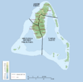
Topographic map of Aitutaki
-
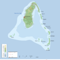
Districts and tapere of Aitutaki
-
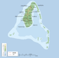
Electoral areas of Aitutaki
-
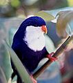
Blue Lorikeet
-

Tapuaetai (One Foot Island) in the southern part of Aitutaki Atoll
-
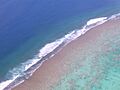
A reef outside of Aitutaki
-
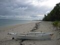
A beach on Aitutaki
See also
 In Spanish: Aitutaki para niños
