Map of Rensselaerswyck facts for kids
Quick facts for kids Map of Rensselaerswyck |
|
 Map of Rensselaerswyck
|
|
| Created | c. 1632 |
| Authors | Unknown |
| Purpose | To document the borders, topography, and locations within Rensselaerswyck |
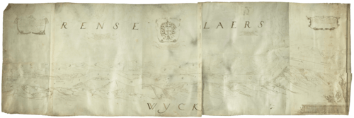
The Map of Rensselaerswyck is an old map made in the 1630s, likely around 1632. It was created for Kiliaen van Rensselaer, a rich Dutch jeweler and a "patroon." A patroon was a special kind of landowner in the New Netherland colony.
Rensselaerswyck was a large area of land in what is now New York. It was the only successful "patroonship" in New Netherland, a colony started by the Dutch West India Company. This company was given permission by the Dutch government to set up colonies and trade. This map is thought to be the very first map ever made of Rensselaerswyck.
Exploring the Old Map
This map is drawn on a large piece of parchment, which is like a very old type of paper made from animal skin. It measures about 22.5 inches by 70 inches. The map shows the land along the Hudson River, from an area called Barren Island (near Coeymans) all the way up to the mouth of the Mohawk River.
Many copies of this map have been made over the years using a printing method called lithography. You can find these copies in old history books about New York and New Netherland.
Who Made the Map?
The map doesn't have a date or the name of the person who drew it. For a long time, people thought a person named Gillis van Schendel made it in 1630. This was because Kiliaen van Rensselaer paid him for a map around that time.
However, the map mentions land that was bought in 1631. This means it must have been made after 1630. Letters from Kiliaen van Rensselaer suggest the map was likely finished in Holland (the Netherlands) shortly after July 20, 1632. It was probably put together using rough sketches and surveys sent by people like Philips Jansz van Haerlem, Crijn Fredericksz, and Albert Dieterinck, who were in the colony.
What the Map Shows
The map was supposed to be drawn to a certain scale, but it's not perfectly accurate. For example, the distance between two points, Beeren Island and Moenemin's Castle, is shown as 4 Dutch miles. But in reality, it's about 22.5 English miles, which is more than the map's scale suggests.
The lower and middle parts of the Hudson River on the map are quite accurate. However, the upper part is not as correct. There's a wide creek called "Renselaers Kill" that seems to be the Mohawk River, but it's in the wrong place. This might have happened because the mapmaker joined two different maps together and didn't know the area well.
Many small creeks on the map only show their mouths, or where they meet the river. The way some creeks are drawn doesn't always match the actual shape of the land. This is probably because the land was sketched from a high point after the river's shoreline was surveyed.
When the map was drawn, there were only three farms in the colony. The small castles shown near names like Godijns Burg and Renselaers Burg don't represent real buildings. Instead, they show where the patroon, Kiliaen van Rensselaer, planned to set up farms in the future. Most of the land bought for Rensselaerswyck was on the west side of the river. Only a small piece of land across from Fort Orange was owned on the east side.
Messages on the Map
The map has several interesting messages written on it, often inside decorative shields or scrolls. These messages give us clues about the colony in the 1630s.
Left Shield Message
This message explains how Kiliaen van Rensselaer bought land from the Mahikans (a Native American nation) on July 28, 1630. This land was on the west side of the Hudson River, both north and south of Fort Orange. The message also says he bought land from Nawanemit, an individual, on the east side of the river, across from Fort Orange.
Left Scroll Message
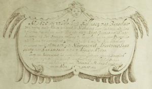
This scroll talks about the wildlife found near Fort Orange, on the south side of de Laet's Island. It says you could shoot many birds there, like geese, swans, wild ducks, cranes, and turkeys. Deer and other game animals were also found in the woods. It even mentions wolves, but notes they were not as big as dogs.
Central Scroll Message
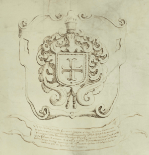
Underneath the van Rensselaer family crest, this scroll describes de Laet's Island. It says there were many tall, straight trees suitable for making oars. It also mentions that the Maquaas (another Native American group) could provide plenty of deer meat, especially in winter. They would trade deer for "seawan" (which is wampum, or shell beads) or even for milk or butter. The message adds that the deer meat was good for smoking or pickling to preserve it.
Right Scroll Message
This scroll talks about a creek called the "Fourth Kill" (which is now called Patroon Creek). It says this creek had many types of fish, including pike. It also mentions that the sturgeon fish there were smaller than those found near the Manathans (Manhattan Island). You could buy a sturgeon from the Native Americans for just a knife!
Right Shield Message
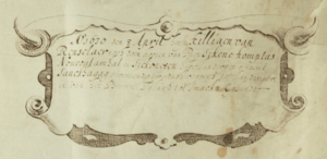
This message states that on April 8, 1630, Kiliaen van Rensselaer bought more land. This land, called Sanckhagag, stretched two days' journey inland from Beeren Island to Smackx Island. He bought it from several Native American individuals.
Naming Places on the Map
Some of the names on the map, like Bijlaers Dael, Weelijs Dael, Twillers Dael, and Pafraets Dael, were chosen to honor Kiliaen van Rensselaer's family members.
- Bijlaers Dael was named after his first wife, Hillegonda van Bijlaer.
- Weelijs Dael was named after his second wife, Anna van Wely.
- Twillers Dael was named after his only sister, Maria, who was the mother of Wouter van Twiller (a governor of New Netherland).
- Pafraets Dael was named after his mother, Maria Pafraet.
The Map Today
The original Map of Rensselaerswyck, or possibly one of its early copies, is now owned by the New York State Museum in Albany, New York. You can see it on display there. It was also part of a special exhibit called "1609," which celebrated 400 years since Henry Hudson arrived in New York.
 | Precious Adams |
 | Lauren Anderson |
 | Janet Collins |


