Mapleton (CDP), Maine facts for kids
Quick facts for kids
Mapleton, Maine
|
|
|---|---|

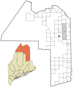
Location of Mapleton, Maine
|
|
| Country | United States |
| State | Maine |
| County | Aroostook |
| Town | Mapleton |
| Area | |
| • Total | 3.00 sq mi (7.78 km2) |
| • Land | 3.00 sq mi (7.78 km2) |
| • Water | 0.00 sq mi (0.00 km2) |
| Elevation | 554 ft (169 m) |
| Population
(2020)
|
|
| • Total | 623 |
| • Density | 207.46/sq mi (80.10/km2) |
| Time zone | UTC-5 (Eastern (EST)) |
| • Summer (DST) | UTC-4 (EDT) |
| ZIP code |
04757
|
| Area code(s) | 207 |
| FIPS code | 23-43220 |
| GNIS feature ID | 2583561 |
Mapleton is a small community in Aroostook County, Maine, in the United States. It is known as a census-designated place (CDP). This means it is a specific area identified by the government for gathering population data. Mapleton is part of the larger town of Mapleton.
In 2010, about 683 people lived in the Mapleton CDP. The entire town of Mapleton had a population of 1,948 people.
Contents
Where is Mapleton Located?
The Mapleton CDP is in the southwestern part of the town of Mapleton. It is located along Maine State Route 163, an important road in the area.
Mapleton is about 5 miles (8 kilometers) east of Presque Isle. It is also about 14 miles (23 kilometers) west of Ashland.
Land Area of Mapleton
The United States Census Bureau reports that the Mapleton CDP covers a total area of about 3.0 square miles (7.8 square kilometers). All of this area is land, with no water.
Who Lives in Mapleton?
This section looks at the population of Mapleton. This is called demographics. It helps us understand how many people live there and how the population changes over time.
Population Changes Over Time
The population of Mapleton has changed over the years. Here is a look at the population from recent counts:
- In 2020, the population was 623 people.
- In 2010, the population was 683 people.
See also
 In Spanish: Mapleton (condado de Aroostook) para niños
 | Sharif Bey |
 | Hale Woodruff |
 | Richmond Barthé |
 | Purvis Young |

