Maracaibo Basin facts for kids
Quick facts for kids Maracaibo Basin |
|
|---|---|
| Depresión del lago de Maracaibo | |

|
|

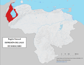
Geographic map of the natural region of Lake Maracaibo Depression.
|
|
| Floor elevation | −12–200 m (−39–656 ft) |
| Area | 36,803 km2 (14,210 sq mi) |
| Geography | |
| Country | Venezuela |
| States | Zulia, Mérida, Trujillo and Táchira |
The Maracaibo Basin, also known as the Lake Maracaibo natural region, is a special area in northwestern Venezuela, South America. It's like a huge bowl or valley surrounded by mountains. This region covers over 36,657 square kilometers.
It is very important because it has a lot of oil and natural gas. So far, over 30 billion barrels of oil have been found here. Experts believe there are still about 44 billion barrels left to discover! In the middle of this basin is a large, shallow lake called Lake Maracaibo. The basin's history is very old, going back to the time of dinosaurs. It helps scientists understand how the land in South America was formed over millions of years.
Contents
What is the Maracaibo Basin like?
The Maracaibo Basin is surrounded by two mountain ranges. To the southeast are the Méridas Andes mountains. To the west are the Sierra de Perija mountains. To the north, it opens up to the Gulf of Venezuela.
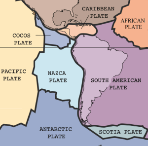
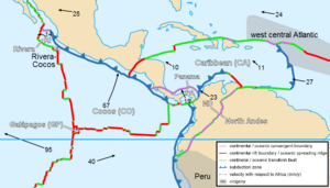
This area is shaped by how the Earth's huge plates move and bump into each other. The Caribbean plate and the South American plate are constantly interacting here. This movement has created three main fault zones around the basin. These fault zones are like big cracks in the Earth's crust. They form a V-shape around a smaller piece of land called the Maracaibo block.
Inside this V-shape, there are even more smaller fault lines. This means the Maracaibo Basin's shape is mostly due to these sliding movements along faults. There are also some folds in the land, like the Maracaibo syncline, which runs north-south through the center of Lake Maracaibo.
How did the Maracaibo Basin form?
The Maracaibo Basin started forming about 160 million years ago. The North American, South American, and Caribbean plates all played a big part in its creation. It went through several stages to become the basin we see today. These stages include the Late Jurassic, Late Cretaceous, Paleocene-Eocene, and Oligocene-Holocene periods.
Late Jurassic Period
During this time, a supercontinent called Pangea began to break apart. The North American plate started to move away from the South American plate. As they separated, they created a wide ocean area called the "Proto-Caribbean Seaway." At the same time, the Caribbean plate began to move eastward from the Pacific Ocean area.
Late Cretaceous Period
After the plates moved apart, the northern edge of the South American plate became a stable "passive margin." This means it was a quiet coastline without much plate activity. This stable period allowed the land to slowly sink, and sediments built up. Later, the Cordillera Central mountains in Colombia began to rise. This uplift was caused by the Caribbean plate moving eastward and interacting with other plates.
Paleocene-Eocene Period
The Caribbean plate kept moving eastward. Eventually, it crashed into the South American plate in the middle of the Paleocene period. This collision changed the quiet coastline into an "active margin." This means there was a lot of plate movement and activity. The Caribbean plate began to slide under the South American plate.
This plate interaction greatly affected northwestern South America. Many basins formed in the region, which filled up with large amounts of sediment. This sediment came from the plate boundaries to the north.
Oligocene-Holocene Period
The Caribbean plate continued its eastward journey. It kept shaping the land in northwestern South America. It also caused changes in the northeastern parts of the continent. As the plates moved, more land was added to the South American plate. This process greatly influenced the formation of mountains in the region.
The Sierra de Perijas mountains rose during the Oligocene period. The Mérida Andes mountains formed later, in the middle Miocene period. As these mountains grew, they eroded, and large amounts of sediment flowed into the basin. The Maracaibo syncline, a large fold in the Earth's crust, formed later in this stage.
How did sediments build up?
The way sediments were deposited in the Maracaibo Basin matches its tectonic history. Major rock formations were created during the same four stages of plate movement.
When Pangea broke apart, the old metamorphic basement rock also broke. This created deep valleys where eroded sediments were deposited. These sediments formed rocks like those found in the La Quinta formation.
Later, when the passive margin formed, a lot of sediment was deposited. This included carbonate and shale rocks. These sediments stayed undisturbed until they were buried deep underground. Some of the most important rocks for oil, like the La Luna and Socuy formations, come from this stage.
The collision of the Caribbean plate is clearly seen in the basin's rocks. There was a sudden change in the type of sediment. Thick layers of shale, like the Colon formation, show when the Caribbean plate began to collide with South America. As the collision continued, the region changed from a quiet coastline to an active basin. The sediments from this time are mostly sandstones, like the Misoa formation. These sandstones are important because they hold oil and gas.
Why is the Maracaibo Basin important for oil?
Oil was first found in large amounts in Venezuela in 1914. This happened in the town of Mene Grande, which is in the eastern part of the Maracaibo Basin. People noticed oil seeping out of the ground there.
In 1922, a company called Royal Dutch Shell discovered the La Rosa Oil Field. A well there, called Barroso, had a huge oil gush, producing 100,000 barrels of oil per day! Later, in 1928, another company found even more oil deposits under Lake Maracaibo itself.
Today, the Maracaibo Basin produces about 50% of Venezuela's oil for export. It also holds about 15% of Venezuela's known oil reserves. The region is home to one of the world's largest oil refinery complexes, the Paraguaná Refinery Complex. Nearby islands like Aruba and Curaçao also have large refineries that process oil from the Maracaibo Basin. All these refineries work together as part of Venezuela's national oil company, PDVSA.
One very important oil field is the Bolivar Coastal Field (BCF). It's on the eastern shore of Lake Maracaibo. This field gets oil from sandstone layers formed in the Miocene and Eocene periods. Other fields, like La Paz, get oil from older limestone layers.
Venezuela produces different types of oil. Some is "conventional heavy crude," which is thicker. Some is "unconventional crude," which comes from bitumen. Bitumen used to be too expensive to get, but now it's becoming more common. In the Maracaibo Basin, most of the oil is still conventional. However, as Venezuela uses more bitumen from other areas, the amount of oil from the Maracaibo Basin might slowly decrease.
See also
 In Spanish: Región natural Depresión del Lago de Maracaibo para niños
 | Madam C. J. Walker |
 | Janet Emerson Bashen |
 | Annie Turnbo Malone |
 | Maggie L. Walker |


