
Mardyke (river) facts for kids
Quick facts for kids Mardyke |
|
|---|---|

The Mardyke near Purfleet
|
|
| Other name(s) | Mar Dyke |
| Country | England |
| Counties | Essex |
| Towns | Thurrock |
| Physical characteristics | |
| Main source | Holden's Wood Between Great Warley and Little Warley 51°35′52.13″N 0°17′36.3″E / 51.5978139°N 0.293417°E |
| River mouth | River Thames Purfleet 51°29′9.29″N 0°13′41.14″E / 51.4859139°N 0.2280944°E |
| Length | 18 km (11 mi) |
| Depth |
|
| Basin features | |
| Basin size | 90.7 km2 (35.0 sq mi) |
The Mardyke is a small river mostly in Thurrock, England. It flows into the famous River Thames at Purfleet. You might also hear it called the Mar Dyke. This river helps form the boundary between two old areas of Essex called Barstable and Chafford. The Mardyke is also important for the Mardyke Valley project. This project helps people enjoy the beautiful land around the river.
Contents
Where Does the Mardyke River Start and Flow?

The Mardyke river begins in Holden's Wood. This wood is located between the villages of Great Warley and Little Warley. From its start, the river flows for about 11 miles (18 km). It ends up in the River Thames near Purfleet. This is close to the large Queen Elizabeth II Bridge.
The Mardyke also has smaller streams that flow into it. Two of these streams come from Thorndon Country Park. One stream flows from Old Hall Pond. This pond is very old, dating back to the 13th century. It has a special gate called a sluice gate. This gate could be opened to create a small waterfall. Waterfalls like this were popular in gardens long ago. Another stream flows from the Langdon Nature Reserve. A third stream flows from Upminster.
What Does the Name "Mardyke" Mean?
The name "Mardyke" means "boundary ditch." This tells us that the river has been used as a border for a very long time. It was mentioned in an old document from 1062. This document described the boundary for the area of Upminster.
The river has also been called "the Flete." This old word means "small estuary," which is where a river meets the sea. Sometimes, people just called it "the brook." For most of its path, the Mardyke acts as a border between different parishes. It also forms part of the boundary between the old Essex areas of Barstable and Chafford.
A Look Back: History of the Mardyke
The Mardyke river flows through a valley that was formed by the River Thames long ago. This valley has ancient woodlands on its sides. The land near the river was used for grazing animals. Old plant evidence shows that new woodlands grew in the Mardyke valley after the Roman period.
Old Bridges and Mills
There is a big bridge over the Mardyke at Stifford. A stone bridge was first built here in 1487. This bridge has been replaced several times since then. Many old items have been found near Stifford Bridge. These include a hammerstone, a small sword, and a special badge worn by pilgrims.
In the 14th century, there was a water mill on the Mardyke at Purfleet. This mill was owned by the Knights Templar, a famous group of medieval knights. Around 1760, special gates called sluice gates were put in place. These gates protected the low-lying land from the salty tidal water of the Thames.
The Mardyke as a Transport Route
The Mardyke was once an important way to travel and move goods. It connected the River Thames to the wet, marshy land further inland. In the 1800s and earlier, boats could travel up the Mardyke as far as Bulphan. Farmers used this waterway to bring manure from London to their farms. They also used it to take their crops to market. In the 1700s, when the river was still affected by tides, boats might have even reached Orsett Hall at high tide.
During the First World War, a prisoner-of-war camp was located near where the Mardyke meets the Thames.
Fun and Nature: Recreation and Wildlife

The river gives its name to the Mardyke Valley project. This project wants to help more people enjoy the outdoor spaces around the Mardyke. It is part of the Thames Chase Community Forest.
The Mardyke Way
A popular part of the project is the Mardyke Way. This is a seven-mile riverside walk. It goes from Ship Lane in Aveley to Orsett Fen. In 2005, the project received a large grant of over £600,000 to help with its work.
The Mardyke Way passes through Davy Down. This is a 32-acre park next to the river. It is located between Lakeside Shopping Centre and South Ockendon. Davy Down opened in 1993. The park has a Victorian viaduct and a pumping station. The pumping station is sometimes open for visitors. The river flows very slowly here, which allows plants like bur reed and common reed to grow. The Mardyke river itself is a special "wildlife corridor." This means it helps plants and animals move safely from one natural area to another.
Mardyke Woods and Golf
North of the Mardyke Way, near Stifford, you'll find Mardyke Woods. These are actually three old woods combined: Brannet's Wood, Millard's Wood, and Low Well Wood.
For those who enjoy golf, the Mardyke Valley Golf Club is located north of the river at Stifford. It has an 18-hole course and opened in 2002.
New Bridge for Nature Lovers
In 2010, a new bridge was opened over the Mardyke at Purfleet. This bridge is called the Veolia Mardyke Bridge. It connects Purfleet to the amazing Rainham Marshes Nature Reserve. This makes it easier for people to explore and enjoy the wildlife there.
Images for kids
-
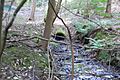
The main source of the Mardyke in Holden's Wood
-
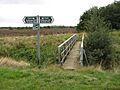
Part of the Mardyke Way at Bulphan
