
Upminster facts for kids
Quick facts for kids Upminster |
|
|---|---|
 Church of St Laurence |
|

Upminster
|
|
| Population | 25,361 (Cranham and Upminster wards 2011) |
| OS grid reference | TQ560865 |
| • Charing Cross | 16.5 mi (26.6 km) WSW |
| London borough | |
| Ceremonial county | Greater London |
| Region | |
| Country | England |
| Sovereign state | United Kingdom |
| Post town | UPMINSTER |
| Postcode district | RM14 |
| Dialling code | 01708 |
| Police | Metropolitan |
| Fire | London |
| Ambulance | London |
| EU Parliament | London |
| UK Parliament |
|
| London Assembly |
|
Upminster is a town in East London, England. It is part of the London Borough of Havering. Upminster is about 16.5 miles (26.6 km) east of Charing Cross, a central point in London. It is an important local town centre.
Long ago, Upminster was a small farming village. Over time, it changed from farming to making bricks, and then became a "garden suburb" with many homes and green spaces. Today, Upminster is mostly a place for shopping, small businesses, and homes.
Upminster first got a train connection to central London in 1885. It now has a terminal station for the London Underground (the Tube). In the 1900s, London grew a lot, and Upminster grew too. It became part of Greater London in 1965.
Contents
History of Upminster
What's in a Name?
The name Upminster was first written down in 1062 as Upmynstre. In the 1086 Domesday Book, it was called Upmunstra. The name comes from old English words: upp (meaning 'high ground') and mynster (meaning 'large church'). So, it means 'the large church on high ground'. This refers to the Church of St Laurence, Upminster, which is on higher ground than the nearby River Ingrebourne.
How Upminster Grew
Around 2,000 years ago, a Roman farm was in the Upminster area. For many centuries, farming was the main way people made a living here.
The area used to have many trees. But in the 1100s, people cleared forests to make more land for growing crops. By the 1600s, farmers grew different crops and raised animals. In the 1800s, growing vegetables for markets became popular. Upminster also had several windmills. One of them, a smock mill built in 1803, is still there today. Other local jobs included making leather, digging for gravel, and a brick factory. The brick factory even had a small railway to the train station in 1895.
The first train line from Fenchurch Street in London reached Upminster in 1885. Later, the District Railway (part of the London Underground) started services to Upminster in 1902. These trains became electric in 1905. After World War I, the electric train lines were extended to Upminster, and direct services started again in 1932.
Town Development
Upminster had three main areas where people lived early on: the village around the church, and the smaller settlements of Hacton and Corbets Tey. In the 1600s, rich merchants from London bought large estates like Gaynes and Upminster Hall. This led to many new buildings and improvements in the town.
Electricity came to Upminster in 1926. Gas for homes and streetlights arrived earlier, in 1872 and 1905. The town also had good natural spring water, with a main water supply starting in 1836. Work on the sewer system began in 1899. In 1929, the local council bought land to create Upminster Park.
Local Government

Upminster is part of the Hornchurch and Upminster area for the UK Parliament. It is also covered by two local areas, called wards, within the Havering London Borough Council: Upminster and Cranham. Each ward chooses three councillors to represent them. The people of Upminster often elect councillors from the Upminster and Cranham Residents' Association. This group is very active in the area.
Geography of Upminster

Upminster is about 200 feet (61 m) above sea level in the north and 50 feet (15 m) in the south. The ground is made of loam, sand, and gravel in the south, and clay in the north. The River Ingrebourne forms the western edge of Upminster. There is also a stream that has been dammed to create a lake near Corbets Tey.
Upminster has been part of London's continuously built-up area since the 1930s. It connects with Cranham to the east and Hornchurch to the west. To the north and south, there are open green spaces. These include Upminster Golf Club, Upminster Hall Playing Field, Upminster Park, and Clock House Gardens. The railway line divides the town into two parts. The north is mainly homes, while the south has the main shopping area. Further south, it becomes mostly homes again.
Population and People
Upminster and Cranham wards together had a population of about 25,098 people in 2001. Most people in Upminster and Cranham identify as Christian. A smaller number say they have no religion.
Compared to other parts of London, Upminster has a very low number of people from different ethnic backgrounds. Most people living here are white. Also, a very high number of people in Upminster own their homes, much more than in other parts of London or England. Upminster is also one of the least deprived areas in London, meaning most people have good living conditions.
The 2011 census showed that 96% of the population was white. About 75% of people in Upminster are Christian, which is the highest percentage in London.
Economy and Shops
Upminster is known as a local district centre in London. It has many shops and businesses. It is one of seven town centres in the Havering area. The main shopping streets are Station Road, St Mary's Lane, and Corbets Tey Road. Most of the shops are small. However, there are also larger stores like the Roomes department store and supermarkets such as Aldi, M&S Simply Food, and Waitrose.
Getting Around Upminster

Upminster has two train stations: Upminster railway station and Upminster Bridge tube station. Both are in London fare zone 6. Upminster and Upminster Bridge stations are on the District line of the London Underground. You can take trains from here to places like Richmond, Ealing Broadway, and Wimbledon through central London.
From Upminster station, c2c trains go to Fenchurch Street in London and Shoeburyness further east. London Overground trains also run from Upminster to Romford. There are also Transport for London bus services that connect Upminster to nearby towns like Hornchurch, Romford, and Lakeside Shopping Centre.
To the south of Upminster is Damyns Hall Aerodrome, a small airfield. The A127 road to the north is a main road into central London. The M25 motorway is about 1.5 miles (2.4 km) east of the town centre.
Culture and Fun

While nearby Hornchurch and Romford have bigger theatres and entertainment places, Upminster has its own cultural spots. New Windmill Hall is a space built in 1968 that can hold up to 300 people for events.
Upminster is home to the Upminster Windmill, which is one of the few old windmills left in Greater London. It is a very important historic building. There is also the Tithe Barn Museum. This museum has old items from homes and farms. In the west of Upminster is Hornchurch Stadium, which is the home ground for the football team A.F.C. Hornchurch. The musician Ian Dury named his 1981 album Lord Upminster after the town.
Measuring the Speed of Sound
The speed of sound was first accurately figured out by Reverend William Derham. He was the church leader (Rector) of Upminster. He improved on earlier ideas by Sir Isaac Newton. Derham used a telescope from the tower of the church of St Laurence, Upminster. He watched for the flash of a distant shotgun being fired. Then, he used a special pendulum to measure how long it took to hear the gunshot. He did this from different places, like the Church of St Mary Magdalene, North Ockendon. Since he knew the exact distance, he could calculate how fast the sound traveled.
Images for kids
-
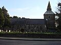
Church of St Laurence, Upminster
-
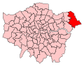
Hornchurch and Upminster constituency in Greater London
-
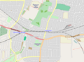
Map of Upminster and environs
-
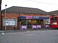
Upminster railway station southern entrance. There is another to the west.
-
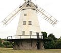
Upminster Windmill is located in a small open space called Windmill Field.
See also
 In Spanish: Upminster para niños
