Cranham facts for kids
Quick facts for kids Cranham |
|
|---|---|
 All Saints' Church, Cranham |
|
| OS grid reference | TQ575875 |
| • Charing Cross | 17.5 mi (28.2 km) WSW |
| London borough | |
| Ceremonial county | Greater London |
| Region | |
| Country | England |
| Sovereign state | United Kingdom |
| Post town | UPMINSTER |
| Postcode district | RM14 |
| Dialling code | 01708 |
| Police | Metropolitan |
| Fire | London |
| Ambulance | London |
| EU Parliament | London |
| UK Parliament |
|
| London Assembly |
|
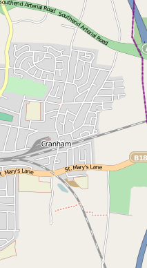
Cranham is a neighborhood in east London, England. It is part of the London Borough of Havering. Cranham is about 28 kilometers (17.5 miles) east-northeast of Charing Cross, a central point in London.
The area has a busy built-up part in the north. To the south, it has a quieter area with fewer buildings. This southern part is a conservation area, meaning it's protected. Open land surrounds it.
Cranham used to be a small farming village in Essex. It was once an ancient parish. Today, it sits on the eastern edge of London's urban sprawl, which is the spread of city areas. Over time, Cranham changed from being mostly farms to having many houses.
In the 20th century, Cranham's population grew a lot. This was because London was expanding. It became part of the Hornchurch Urban District in 1934. Since 1965, Cranham has been part of Greater London. The number of people living in Cranham in 2011 was counted with Upminster.
Contents
Cranham's Past: A Look Back in Time
How Cranham Got Its Name
| 1881 | 416 |
|---|---|
| 1891 | 465 |
| 1901 | 397 |
| 1911 | 489 |
| 1921 | 519 |
| 1931 | 1,240 |
| 1941 | war # |
| 1951 | 2,836 |
| # no census was held due to war | |
| source: UK census | |
Cranham is mentioned in the Domesday Book from 1086. This was a very old survey of England. The book shows Cranham had two main areas, called manors.
The smaller manor in the north was called Craohv. By 1201, it was known as Craweno. This name means 'a piece of land shaped like a spur, where crows often visit'. It comes from old English words.
The larger manor was called Ockendon. For many years, until about the 1400s, it was also known as Bishop's Ockendon. This was because the Bishop of London owned a large part of the land.
How Cranham's Economy Developed
In 1086, Cranham was mostly thick forest. People lived by farming the land. By the 1400s, much of the forest had been cleared. This led to more people and more land for growing crops. There was even a mill in Cranham.
Cranham had special clay soil called brick earth. This led to the Cranham Brick and Tile Company. It made bricks and tiles from 1900 to 1920. Early trade likely happened with nearby towns like Romford and Hornchurch. Goods could also be sent to London using the River Thames from Rainham.
The Growth of Cranham as a Town
In the 1600s and 1700s, large homes like Cranham Hall became popular. Rich business people from the City of London wanted to buy them.
At first, it was hard to build new houses in Cranham in the early 1900s. There wasn't enough water. In 1922, new sewage systems were built for Upminster and Cranham. This helped with development.
In the 1930s, some land was used to build council houses. More new buildings went up after a large estate was sold. Cranham is on the very edge of London's built-up area. This is partly because of the Metropolitan Green Belt. This is a protected area of open land around London. World War II also slowed down building.
After the war, building continued in a specific area. By 1971, 615 council houses had been built.
How Cranham is Governed
Cranham is part of the Hornchurch and Upminster area. This area elects a Member of Parliament (MP) to the UK Parliament. The current MP is Julia Lopez (politician).
Cranham is also divided into local areas called wards. These are Upminster and Cranham wards. Each ward chooses three local councillors. These councillors work for the Havering London Borough Council.
It's interesting that the Upminster and Cranham Residents' Association is very active here. In 2010, all six councillors elected for these wards were from this association. This shows how strong local community groups are in Cranham.
Cranham's Geography and Nature
Most of Cranham is on a type of soil called London Clay. There is richer soil (loam) to the north. A valley with gravel is found to the south. The land rises to about 76 meters (250 feet) in the north. It goes down to below 15 meters (50 feet) in the south. A ridge runs from east to west, where All Saints' Church is located.
Cranham is connected to Upminster in the west. However, open fields separate it from other towns. These include Harold Wood to the north, Great Warley to the east, and North Ockendon to the southeast.
Franks Wood and Cranham Brickfields are special places for nature. They are called a Site of Importance for Nature Conservation. Here you can find old woodlands, small forests, ditches, and wild grasslands. The main center for Thames Chase, a large community forest, is in the open land to the southeast.
Cranham is part of the Upminster post town. Its postcode is RM14. The weather information for Cranham is taken from Greenwich. This weather station is about 19 kilometers (12 miles) southwest of All Saints' Church.
| Climate data for London (Greenwich) | |||||||||||||
|---|---|---|---|---|---|---|---|---|---|---|---|---|---|
| Month | Jan | Feb | Mar | Apr | May | Jun | Jul | Aug | Sep | Oct | Nov | Dec | Year |
| Record high °C (°F) | 14.0 (57.2) |
19.7 (67.5) |
21.0 (69.8) |
26.9 (80.4) |
31.0 (87.8) |
35.0 (95.0) |
35.5 (95.9) |
37.5 (99.5) |
30.0 (86.0) |
28.8 (83.8) |
19.9 (67.8) |
15.0 (59.0) |
37.5 (99.5) |
| Mean daily maximum °C (°F) | 8.3 (46.9) |
8.5 (47.3) |
11.4 (52.5) |
14.2 (57.6) |
17.7 (63.9) |
20.7 (69.3) |
23.2 (73.8) |
22.9 (73.2) |
20.1 (68.2) |
15.6 (60.1) |
11.4 (52.5) |
8.6 (47.5) |
15.2 (59.4) |
| Mean daily minimum °C (°F) | 2.6 (36.7) |
2.4 (36.3) |
4.1 (39.4) |
5.4 (41.7) |
8.4 (47.1) |
11.5 (52.7) |
13.9 (57.0) |
13.7 (56.7) |
11.2 (52.2) |
8.3 (46.9) |
5.1 (41.2) |
2.8 (37.0) |
7.5 (45.5) |
| Record low °C (°F) | −10.0 (14.0) |
−9.0 (15.8) |
−8.0 (17.6) |
−2.0 (28.4) |
−1.0 (30.2) |
5.0 (41.0) |
7.0 (44.6) |
6.0 (42.8) |
3.0 (37.4) |
−4.0 (24.8) |
−5.0 (23.0) |
−7.0 (19.4) |
−10.0 (14.0) |
| Average precipitation mm (inches) | 51.6 (2.03) |
38.2 (1.50) |
40.5 (1.59) |
45.0 (1.77) |
46.5 (1.83) |
47.3 (1.86) |
41.1 (1.62) |
51.6 (2.03) |
50.4 (1.98) |
68.8 (2.71) |
58.0 (2.28) |
53.0 (2.09) |
591.8 (23.30) |
| Average rainy days (≥ 1.0 mm) | 10.8 | 8.5 | 9.6 | 9.4 | 9.0 | 8.3 | 8.0 | 7.6 | 8.5 | 10.7 | 10.1 | 9.9 | 110.4 |
| Average snowy days | 4 | 4 | 3 | 1 | 0 | 0 | 0 | 0 | 0 | 0 | 1 | 3 | 16 |
| Average relative humidity (%) | 81.0 | 76.0 | 69.0 | 64.0 | 62.0 | 60.0 | 60.0 | 62.0 | 67.0 | 73.0 | 78.0 | 82.0 | 69.5 |
| Mean monthly sunshine hours | 49.9 | 71.4 | 107.1 | 159.8 | 181.2 | 181.0 | 192.1 | 195.1 | 138.9 | 108.1 | 58.5 | 37.4 | 1,480.5 |
| Source 1: Record highs and lows from BBC Weather, except August and February maximum from Met Office | |||||||||||||
| Source 2: All other data from Met Office, except for humidity and snow data which are from NOAA | |||||||||||||
| Climate data for London (Heathrow airport 1981−2010) | |||||||||||||
|---|---|---|---|---|---|---|---|---|---|---|---|---|---|
| Month | Jan | Feb | Mar | Apr | May | Jun | Jul | Aug | Sep | Oct | Nov | Dec | Year |
| Mean daily maximum °C (°F) | 8.1 (46.6) |
8.4 (47.1) |
11.3 (52.3) |
14.2 (57.6) |
17.9 (64.2) |
21.0 (69.8) |
23.5 (74.3) |
23.2 (73.8) |
19.9 (67.8) |
15.5 (59.9) |
11.1 (52.0) |
8.3 (46.9) |
15.2 (59.4) |
| Mean daily minimum °C (°F) | 2.3 (36.1) |
2.1 (35.8) |
3.9 (39.0) |
5.5 (41.9) |
8.7 (47.7) |
11.7 (53.1) |
13.9 (57.0) |
13.7 (56.7) |
11.4 (52.5) |
8.4 (47.1) |
4.9 (40.8) |
2.7 (36.9) |
7.4 (45.4) |
| Average precipitation mm (inches) | 55.2 (2.17) |
40.9 (1.61) |
41.6 (1.64) |
43.7 (1.72) |
49.4 (1.94) |
45.1 (1.78) |
44.5 (1.75) |
49.5 (1.95) |
49.1 (1.93) |
68.5 (2.70) |
59.0 (2.32) |
55.2 (2.17) |
601.7 (23.68) |
| Average rainy days (≥ 1.0 mm) | 11.1 | 8.5 | 9.3 | 9.1 | 8.8 | 8.2 | 7.7 | 7.5 | 8.1 | 10.8 | 10.3 | 10.2 | 109.6 |
| Mean monthly sunshine hours | 61.5 | 77.9 | 114.6 | 168.7 | 198.5 | 204.3 | 212.0 | 204.7 | 149.3 | 116.5 | 72.6 | 52.0 | 1,632.6 |
| Source: Met Office | |||||||||||||
Who Lives in Cranham: Demographics
| Cranham compared (2001 Census) | |||||
|---|---|---|---|---|---|
| Statistic | Upminster | Cranham | Havering | London | England |
| Ethnic group | |||||
| White | 12,354 | 11,930 | 213,421 | 5,103,203 | 44,679,361 |
| Asian | 133 | 120 | 4,088 | 866,693 | 2,248,289 |
| Black | 59 | 64 | 3,139 | 782,849 | 1,132,508 |
| Mixed | 87 | 78 | 2,298 | 226,111 | 643,373 |
| Chinese/Other | 41 | 19 | 827 | 70,928 | 231,424 |
| Population | |||||
| Total | 12,674 | 12,242 | 224,248 | 7,172,091 | 49,138,831 |
| Density(/hectare) | 5.62 | 18.67 | 19.97 | 45.62 | 3.77 |
| Households | 4,946 | 5,111 | 91,722 | 3,015,997 | 20,451,427 |
The Office for National Statistics collects information about people in Cranham. This data is for the Cranham and Upminster wards. These wards include Cranham, Upminster, and North Ockendon.
In 2001, the Upminster ward had 12,674 people. The Cranham ward had 12,242 people. This made a total population of 25,098.
Most people in Cranham and Upminster (over 80%) said they were Christian. This is higher than in London as a whole. A smaller number (around 10%) said they had no religion.
Cranham and Upminster wards have a low number of people from different ethnic backgrounds. About 3% of the population in 2001 was from black and minority ethnic groups. This is lower than in other parts of London.
Also, many people in Cranham own their homes. Over 90% of houses in both wards are owned by the people living in them. This is much higher than the average for London and England.
Cranham's Economy: Shops and Businesses
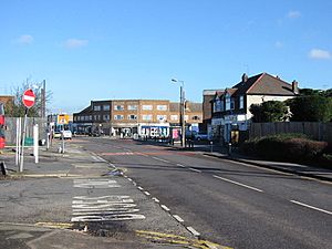
Cranham has several small rows of shops. The biggest one is on Front Lane. It has a large Tesco Express supermarket. The main shopping area nearby is in Upminster. This is considered a local district center in London's plans. Within Havering, Upminster is one of the seven main town centers.
There are also some businesses near the A127 Southend Arterial Road. These include a wholesale butcher, a mushroom farm, and places that sell caravans and sports equipment. For eating out, Cranham has a few pubs and a popular Indian restaurant.
Getting Around: Transport in Cranham
Front Lane is the main road in Cranham. It runs from north to south. It connects to the A127 road in the north. About 0.8 kilometers (0.5 miles) northeast, it meets the M25 motorway. The M25 is a large ring road that goes around London.
Cranham is home to the Upminster depot for the London Underground's District line. This is where trains are stored and maintained. The closest London Underground station is Upminster. It's about 1.2 kilometers (0.75 miles) to the west.
The London, Tilbury and Southend line train tracks also pass through Cranham. The nearest station for these trains is also at Upminster.
Transport for London runs several bus services in Cranham. These buses connect Cranham to Upminster, Hornchurch, Romford, and Ockendon station. The bus routes are 248, 346, and 347.
Culture and Community in Cranham
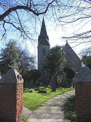
All Saints' parish church was rebuilt in 1873. It is a Grade II listed building, meaning it's historically important. James Oglethorpe, who founded the state of Georgia in the United States, is buried here with his wife. The area around the church is a protected conservation area.
There is another church called St Luke's further north on Front Lane. Cranham Hall, which used to be the main manor house, is also a Grade II listed building.
Cranham has two community groups that are registered charities. The Cranham Community Association runs many activities. These include sports, learning new skills, and hobbies. They meet at the Cranham Community Centre on Marlborough Gardens.
The Front Lane Community Association runs Cranham Social Hall. This hall can hold 100 people. It offers a smaller range of activities. For bigger cultural events and entertainment, people usually go to Hornchurch and Romford.
 | Tommie Smith |
 | Simone Manuel |
 | Shani Davis |
 | Simone Biles |
 | Alice Coachman |


