Mareth Line facts for kids
Quick facts for kids Mareth Line |
|
|---|---|
| Part of French defence of Tunisia | |
| Tunisia | |

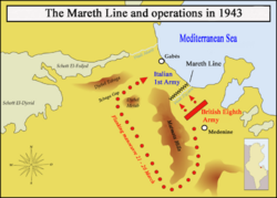
Mareth Line in 1943
|
|
| Coordinates | 33°38′00″N 10°18′00″E / 33.63333°N 10.30000°E |
| Height | 2,200 feet (670 m) |
| Length | 25 miles (40 km) |
| Site information | |
| Owner | French colonial administration of Tunisia |
| Operator | French army (1939–1940) |
| Controlled by | German–Italian Panzer Army (Deutsch-Italienische Panzerarmee/Armata Corazzata Italo-Tedesca) [1943] |
| Condition | Derelict |
| Site history | |
| Built | 1936 |
| Built by | French colonial administration of Tunisia and French Army |
| In use | March 1943 |
| Materials | reinforced concrete |
| Fate | Abandoned after 1943 |
| Battles/wars | Battle of the Mareth Line |
| Garrison information | |
| Past commanders |
Erwin Rommel |
| Garrison | 1943, east to west: 136th Infantry Division Giovani Fascisti, 101st Motorised Division Trieste, 90th Light Division, 80th Infantry Division La Spezia, 16th Motorised Division Pistoia, 164th Light Afrika Division 15th Panzer Division (32 operational tanks) Reserve: 21st Panzer Division, 10th Panzer Division (110 operational tanks); Djebel Tebaga to Djebel Melab: Raggruppamento Sahariano |
The Mareth Line was a strong defensive wall built by France in southern Tunisia. It was constructed in the late 1930s. The main goal of this line was to protect Tunisia from a possible attack by Italy. Italy had a colony next door in Libya.
The Mareth Line was built in a special spot. This area was where all the roads leading into Tunisia from the south came together. To the east was the Mediterranean Sea, and to the west were mountains and a huge sand desert. The line stretched for about 50 kilometers (31 miles) along the north side of a riverbed called Wadi Zigzaou. It went from the Gulf of Gabès to the Matmata mountains.
After France signed an agreement in 1940, the Mareth Line was taken apart. This was watched over by Italian and German officials. Later, in 1942, Axis forces took over Tunisia during Operation Torch. They rebuilt and made the Mareth Line even stronger. They added more defenses between the line and Wadi Zeuss, about 3.5 miles (5.6 km) to the south.
In March 1943, two big battles happened here. The Battle of Medenine was a failure for the Axis forces. Then, during the Battle of the Mareth Line, the British Eighth Army was stopped at the line. However, the British found a way around the line. This led to a breakthrough at the Tebaga Gap. The Axis forces had to leave the Mareth Line and retreat. Today, the Mareth Line is abandoned, but you can learn about it at the Mareth Museum.
Contents
Why Was the Mareth Line Built?
French Plans for Defense
In the 1930s, France had a huge colonial empire around the world. To defend these colonies, they mostly relied on special military units. These included the French Foreign Legion and local troops. The French Navy and Air Force also played a part. However, by the late 1930s, their navy had only one aircraft carrier. Their air force had older planes.
Algeria, Morocco, and Tunisia were very important. They provided many soldiers for the French army. Tunisia, especially, was a concern because it was next to Libya, an Italian colony. France worried Italy might attack Tunisia. French military leaders thought Italy would launch a huge attack. They believed France couldn't easily stop it.
So, the French army decided to build a strong defense. They thought about building a "Maginot Line in the desert." The Maginot Line was a famous line of forts in France. This desert version would be the Mareth Line.
The Land Around the Mareth Line
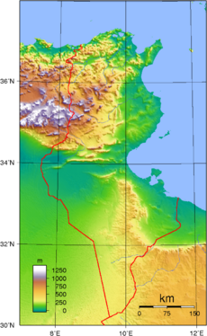
Central Tunisia has the Atlas Mountains. But the northern and southern parts are mostly flat. In the south, the main feature is the Matmata Hills. These hills run north to south, close to the Mediterranean coast. West of these hills, the land is a harsh desert called the Jebel Dahar. This makes the area between the hills and the coast the easiest way to get to northern Tunisia.
There's also a smaller line of hills running east to west. This makes the approach even harder. At the very north end of the Matmata Hills is the Tebaga Gap. From the sea, the land gently rises to the Matmata Hills. The ground is made of gravel and sand. There are also salt flats that turn into muddy bogs after rain. This makes it impossible for vehicles to pass.
Many riverbeds, called wadis, flow from the hills to the sea. These include the bigger Wadi Zeuss and Wadi Zigzaou. Inland, the wadis are steep and rocky. But near the coast, they get wider. Their bottoms can be muddy, but some areas are firm enough for vehicles.
Building the Fortifications
In January 1934, planning for the new forts began. Army officers chose the best spots for strongpoints. These spots would allow their guns to cover the land in front with overlapping fire. In 1936, the French government gave money for construction. This happened after Italy and Germany formed an alliance, called the Rome–Berlin Axis. This made the threat to French security in North Africa even greater.
The forts, called casemates, were designed with less concrete than similar ones in France. They also had a special door in case the lower part got blocked. By September 1936, it was decided that the Mareth Line and other defenses had to be finished. These other places included Medenine and Ben Gardane.
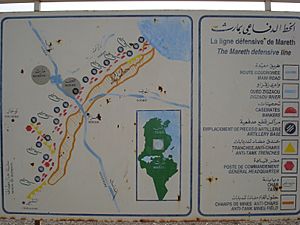
The Mareth Line was split into eastern and western parts. It had a main line of defense and a backup line about 1.5 kilometers (0.93 miles) behind it. A special defensive area was also planned for the rocky Dahar Plateau. This later became part of a larger defense across the Matmata Hills. The gap between the Mareth Line and the Great Eastern Sand Sea was a possible way for an enemy to go around the line. But this area wasn't really looked at until 1938.
What Was the Mareth Line Like?
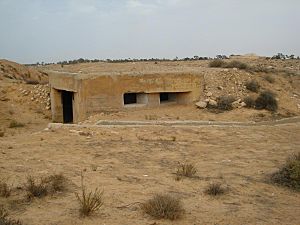
The Mareth Line was made of strong concrete bunkers called casemates. These were surrounded by barbed wire. They were built to defend from all directions, both in the main and backup lines. The obstacles were even stronger at the front and sides. The main strongpoints had machine-gun bunkers and anti-tank gun positions. In the backup line, artillery positions provided covering fire for the gaps in the main line.
Some machine-gun bunkers were connected by underground tunnels. Strongpoints on the flat land and in the hills had anti-tank positions. A barrier of vertical metal rails was built along the front of the line to stop tanks. The sides of Wadi Zigzaou were also made steeper. In total, eight artillery bunkers, forty infantry bunkers or blockhouses, and fifteen command posts were built.
The eastern part of the line had twelve strongpoints in the main line and eleven in the backup line. The western part had eleven strongpoints in the main line and seven in the backup line.
In the Matmata hills, a place called Ksar el Hallouf had an anti-tank ditch. This ditch extended the defense beyond the main line. An infantry position was dug into the Matmata hills at Ksar-el-Hallouf. Further out in the Dahar desert, a strongpoint at Bir Soltane had two 75 mm gun turrets. These turrets were taken from old tanks built in 1918.
The Mareth Line used older 75 mm and 47 mm naval guns for anti-tank defense. It also had some newer 25 mm anti-tank guns and small arms for infantry. By 1939, the line was staffed by colonial divisions and local units. After World War II started, a line of advanced positions was built about 10 kilometers (6.2 miles) south of the main line.
The Mareth Line in World War II
Changes to the Line (1940-1943)
World War II began in 1939. But the Mareth Line was quiet from 1939 to 1940. Italy stayed neutral until just before France signed an agreement in June 1940. After that, the line was taken apart by a German-Italian group.
In November 1942, the British Eighth Army, led by General Bernard Montgomery, defeated the German-Italian army in Egypt. At the same time, the British First Army landed in North Africa. Axis forces then took over Tunisia. From November 1942 to March 1943, the German-Italian army slowly retreated through Egypt and Libya. The Eighth Army followed them closely.
In March 1943, the Eighth Army reached the border between Libya and Tunisia. They paused at Medenine to get ready to attack the Mareth Line. Axis engineers built new defenses in front of the Mareth Line. They laid over 100 kilometers (62 miles) of barbed wire. They also placed 100,000 anti-tank mines and 70,000 anti-personnel mines. Bunkers were made stronger with concrete and armed with anti-tank and anti-aircraft guns.
Battles at Medenine and Mareth
The Axis forces facing the Eighth Army were renamed the Italian 1st Army in February 1943. They tried a surprise attack called the Battle of Medenine. But this attack failed badly. The Axis troops then went back to the Mareth Line to wait for the British attack. General Erwin Rommel, a famous German commander, called the Mareth Line "a line of old French blockhouses." He said they were "in no way measured up to the standards required by modern warfare."
The Mareth Line was defended by several divisions. These included Italian and German units. For example, the "Giovani Fascisti" Division was near the coast. The "Trieste" Division covered the main road. Other divisions like the "La Spezia" and "Pistoia" divisions held different parts of the line. Two Panzer (tank) divisions were kept in reserve.
The Battle of the Mareth Line
On March 19, 1943, the Eighth Army launched a direct attack on the Mareth Line. This was called Operation Pugilist. The British 50th Northumbrian Infantry Division broke through near Zarat. But they were pushed back by German and Italian forces a few days later.
However, British scouts had found a way to go around the line. A force could pass through the southern Matmata Hills and reach the Tebaga Gap from the west. From there, they could get to the coastal plain behind the Mareth Line. So, the British sent the 2nd New Zealand Division around the Matmata Hills. But their attack was stopped at the Tebaga Gap.
The British then sent the 1st Armoured Division to help the attack at the Tebaga Gap. They attacked again on March 26 in Operation Supercharge II. They broke through the gap the next day. This success, along with another direct attack on the Mareth Line, made the Axis position impossible to hold. The Italian 1st Army managed to escape being surrounded. They retreated to Wadi Akarit, about 60 kilometers (37 miles) to the north.
What Happened After the War?
After the Battle of the Mareth Line, the defenses were left to fall apart. Today, they are abandoned. But the history of the Mareth Line is remembered at the Mareth Museum in Gabès, Tunisia.
 | Bessie Coleman |
 | Spann Watson |
 | Jill E. Brown |
 | Sherman W. White |


