Marquette River West facts for kids
Quick facts for kids Marquette West |
|
|---|---|

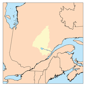
Watershed of Saguenay River
|
|
| Country | Canada |
| Province | Quebec |
| Region | Saguenay-Lac-Saint-Jean |
| Physical characteristics | |
| Main source | Coursy Lake Lac-Ashuapmushuan, Quebec, Le Domaine-du-Roy (RCM), Saguenay-Lac-Saint-Jean, Quebec 455 m (1,493 ft) 48°54′30″N 74°02′32″W / 48.90833°N 74.04222°W |
| River mouth | Ashuapmushuan Lake Lac-Ashuapmushuan, Quebec, Le Domaine-du-Roy (RCM), Saguenay-Lac-Saint-Jean, Quebec 373 m (1,224 ft) 49°09′14″N 73°55′00″W / 49.15389°N 73.91667°W |
| Length | 54.7 km (34.0 mi) |
| Basin features | |
| Tributaries |
|
The Marquette West River is a river in Quebec, Canada. It flows into the Marquette River, which then leads to Ashuapmushuan Lake. This area is part of the Saguenay-Lac-Saint-Jean region.
The river passes through different areas called townships, like Huard and Buade. It flows just west of the Ashuapmushuan Wildlife Reserve. The main activities in this river valley are forestry (cutting down trees) and tourism (people visiting for fun).
A forest road, R0212, crosses the middle part of the Marquette West River. Also, Route 167, a main road connecting Chibougamau to Saint-Félicien, Quebec, runs nearby.
The river's surface usually freezes from early November until mid-May. However, it's generally safe to walk or travel on the ice from mid-November to mid-April.
Contents
River's Journey
The Marquette West River starts from a lake called Coursy Lake. This lake is about 1.6 kilometers long and 0.5 kilometers wide. It sits at an elevation of 455 meters above sea level. Coursy Lake gets most of its water from Lake Livaie.
The river flows for about 54.7 kilometers (about 34 miles) from Coursy Lake to where it joins the Marquette River.
Upper Part of the River
The first part of the Marquette West River is about 23.2 kilometers long.
- It flows northeast for 1.1 kilometers.
- Then, it turns north for 8.1 kilometers, going through Palluau Lake. This lake is quite large and has a unique shape.
- Next, it flows northwest for 6.0 kilometers, collecting water from Duminy Lake.
- Finally, it goes northeast for 8.0 kilometers, picking up water from other lakes like Harnoy and Paladru.
Middle Part of the River
The middle section of the river is about 20.2 kilometers long.
- It flows north for 3.0 kilometers, creating some small streams.
- It continues north for another 3.5 kilometers, still forming small streams.
- Then, it flows north for 7.4 kilometers, collecting water from Farley Lake and Pinette Lake.
- It goes north for 2.6 kilometers through a marshy area.
- Lastly, it flows northeast for 3.7 kilometers, getting water from lakes like Florimond and Enneplon.
Lower Part of the River
The last part of the Marquette West River is about 11.3 kilometers long.
- It flows east for 9.3 kilometers, passing through marshy areas. It then turns southeast, collecting water from lakes like Cramans and Glisy.
- Finally, it flows east for 2.0 kilometers, making a loop to the north before reaching its end.
The Marquette West River joins the Marquette River on its west side. From there, the water flows along the Marquette River to Ashuapmushuan Lake. After that, the water continues through the Ashuapmushuan River, which eventually flows into Lac Saint-Jean near Saint-Félicien, Quebec.
River's Name
The name "Marquette West River" honors Jacques Marquette. He was a French Jesuit missionary and explorer who lived from 1637 to 1675.
- Jacques Marquette first learned different Native American languages.
- He worked on various missions, including one with the Outaouais people.
- In 1671, he started the Saint-Ignace mission for the Wendat (Hurons) people.
- In 1672, he met Louis Jolliet. Together, they explored the Mississippi River, traveling as far south as what is now the border of Arkansas and Louisiana.
- Father Marquette wanted to start another mission with the Kaskaskias people in Illinois, but he had to give up because he became ill.
The name "Rivière Marquette Ouest" (which means Marquette West River in French) was officially recognized on March 28, 1972, by the Commission de toponymie du Québec (Quebec's Place Names Commission).
 | Valerie Thomas |
 | Frederick McKinley Jones |
 | George Edward Alcorn Jr. |
 | Thomas Mensah |

