
Chibougamau facts for kids
Quick facts for kids
Chibougamau
|
|||
|---|---|---|---|
|
City
|
|||

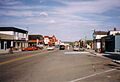
Chibougamau main street
|
|||
|
|||

Chibougamau
Location in Quebec

Chibougamau
Location in Canada
|
|||
| Country | Canada | ||
| Province | Quebec | ||
| Region | Nord-du-Québec | ||
| RCM | None | ||
| Settled | 1952 | ||
| Constituted | November 8, 1952 | ||
| Area
(2021)
|
|||
| • Total | 1,039.89 km2 (401.50 sq mi) | ||
| • Land | 698.13 km2 (269.55 sq mi) | ||
| • Water | 341.76 km2 (131.95 sq mi) | ||
| Population
(2021)
|
|||
| • Total | 7,233 | ||
| • Density | 10.4/km2 (27/sq mi) | ||
| • Change (2016–21) | |||
| • Dwellings | 3,557 | ||
| Time zone | UTC−05:00 (EST) | ||
| • Summer (DST) | UTC−04:00 (EDT) | ||
| Postal code(s) |
G8P
|
||
| Area code(s) | 418 and 581 | ||
| Climate | Dfc | ||

.svg)
Chibougamau is the biggest town in Nord-du-Québec, a region in central Québec, Canada. It's located by Lake Gilman and has about 7,233 people (as of 2021). Even though it's surrounded by a larger area called Eeyou Istchee James Bay, Chibougamau is its own separate town.
Chibougamau is quite far from other big cities. This means it's an important place that provides services for smaller nearby communities like Mistissini, Oujé-Bougoumou, and Chapais. It also supports industries that use natural resources in the area.
The town is named after Chibougamau Lake, which is fed by the Chibougamau River. The word Chibougamau means "gathering place" in the Cree language. The nearby Cree village of Oujé-Bougoumou has a similar name.
You can get to Chibougamau by Route 167 from Lac Saint-Jean or by Route 113 from Lebel-sur-Quévillon. The town's airport is on Route 113, between Chibougamau and Chapais.

Contents
Discovering Chibougamau's Past
.jpg)
The land around Chibougamau has been home to the Cree people for a very long time. In the early 1600s, French explorers and traders, like Charles Albanel in 1671, visited the Lake Chibougamau area. However, no European towns were built there back then.
Mining and Growth
Later, in the late 1800s, people became interested in the area for its mining potential. When gold was found in 1903, many prospectors came to explore. But it was hard to get to the area, so no lasting towns were built at that time.
It wasn't until 1949 that copper mining really started. A new mine opened, and a permanent community was finally created in 1952. Chibougamau began as a "company town," meaning it was built for the mine workers. Soon after, in 1954, it officially became a municipality. Many mines have operated here since then.
Today, Chibougamau is still known for mining. But it's also a big center for logging and sawmill work, where trees are cut down and turned into lumber.
Past Military Base
From 1962 to 1988, the Royal Canadian Air Force had a radar station in Chibougamau called CFS Chibougamau. It was part of a defense system called the Pinetree Line. Now, that old military site has been turned into a golf course and offices for a mining company.
Local Government and Fun Festivals
Since 2001, the mayor of Chibougamau also serves on the council for the larger Municipality of Baie-James.
The city hosts fun events each year. These include the "Folies frettes" festival, which means "Cold Follies," and an exciting snowmobile race.
Chibougamau's People
|
|||||||||||||||||||||||||||
In 2021, the population of Chibougamau was about 7,233 people. This was a small decrease from 2016. The town covers an area of about 694.87 square kilometers.
Most people in Chibougamau speak French as their first language (92.5%). Some people speak English (3.0%), and others speak Cree-Innu languages (1.6%).
About 7.8% of the people in Chibougamau are Indigenous peoples. The largest groups of visible minorities include Black people (1.5%), Filipino people (1.1%), and Arab people (0.8%).
Most people (67.7%) identify as Catholic. About 22.8% say they have no religious connection.
Learning in Chibougamau
Chibougamau has several schools where students can learn.
French-Language Schools
Here are some of the French-language schools that have been in Chibougamau:
- École Bon-Pasteur
- École Vatican II
- École Notre-Dame-du-Rosaire
- École La Porte-du-Nord
- École Vinette (this school closed in 1994)
- Centre de formation professionnelle de la Baie-James (a vocational training center)
- Centre d'études collégiales Chibougamau (a college studies center)
English-Language Schools
The main English-language school is MacLean Memorial School. It used to be called Chibougamau Protestant School. There was also an English-language Catholic school called Holy Family School.
Chibougamau's Climate
Chibougamau has a subarctic climate. This means it has long, cold, and snowy winters. In January, the average high temperature is about -13.5°C, and the low is around -24.2°C.
Summers are warm but short. In July, the average high is about 22.2°C, and the low is around 10.5°C.
The area gets a lot of precipitation (rain and snow) throughout the year. On average, it receives about 996 mm of precipitation and 313 cm of snow each season. February, March, and April are usually a bit drier.
| Climate data for Chapais (1981−2010) (49°47′N 074°51′W / 49.783°N 74.850°W) approximately 37 km (23 mi) southwest | |||||||||||||
|---|---|---|---|---|---|---|---|---|---|---|---|---|---|
| Month | Jan | Feb | Mar | Apr | May | Jun | Jul | Aug | Sep | Oct | Nov | Dec | Year |
| Record high °C (°F) | 8.5 (47.3) |
9.0 (48.2) |
16.0 (60.8) |
28.0 (82.4) |
31.5 (88.7) |
34.5 (94.1) |
35.0 (95.0) |
33.3 (91.9) |
29.0 (84.2) |
24.4 (75.9) |
17.8 (64.0) |
11.0 (51.8) |
35.0 (95.0) |
| Mean daily maximum °C (°F) | −13.5 (7.7) |
−10.3 (13.5) |
−3.3 (26.1) |
5.2 (41.4) |
13.9 (57.0) |
20.0 (68.0) |
22.2 (72.0) |
20.5 (68.9) |
14.2 (57.6) |
6.7 (44.1) |
−1.9 (28.6) |
−9.3 (15.3) |
5.4 (41.7) |
| Daily mean °C (°F) | −18.8 (−1.8) |
−16.2 (2.8) |
−9.5 (14.9) |
−0.3 (31.5) |
8.1 (46.6) |
14.1 (57.4) |
16.4 (61.5) |
15.0 (59.0) |
9.7 (49.5) |
3.1 (37.6) |
−5.2 (22.6) |
−13.6 (7.5) |
0.2 (32.4) |
| Mean daily minimum °C (°F) | −24.2 (−11.6) |
−22.2 (−8.0) |
−15.5 (4.1) |
−5.7 (21.7) |
2.2 (36.0) |
8.2 (46.8) |
10.5 (50.9) |
9.5 (49.1) |
5.2 (41.4) |
−0.5 (31.1) |
−8.5 (16.7) |
−18 (0) |
−4.9 (23.2) |
| Record low °C (°F) | −43.3 (−45.9) |
−42.8 (−45.0) |
−38 (−36) |
−27.2 (−17.0) |
−16.1 (3.0) |
−5.6 (21.9) |
−0.6 (30.9) |
−2.2 (28.0) |
−6 (21) |
−13.3 (8.1) |
−30 (−22) |
−42 (−44) |
−43.3 (−45.9) |
| Average precipitation mm (inches) | 61.9 (2.44) |
39.4 (1.55) |
50.3 (1.98) |
56.6 (2.23) |
82.4 (3.24) |
100.1 (3.94) |
124.3 (4.89) |
100.2 (3.94) |
129.7 (5.11) |
93.9 (3.70) |
93.2 (3.67) |
63.5 (2.50) |
995.5 (39.19) |
| Average rainfall mm (inches) | 3.2 (0.13) |
2.4 (0.09) |
8.8 (0.35) |
28.7 (1.13) |
75.5 (2.97) |
100.1 (3.94) |
124.3 (4.89) |
100.2 (3.94) |
128.6 (5.06) |
70.9 (2.79) |
36.7 (1.44) |
5.0 (0.20) |
684.4 (26.93) |
| Average snowfall cm (inches) | 58.8 (23.1) |
37.0 (14.6) |
41.6 (16.4) |
29.5 (11.6) |
6.9 (2.7) |
0.0 (0.0) |
0.0 (0.0) |
0.0 (0.0) |
1.2 (0.5) |
23.0 (9.1) |
56.5 (22.2) |
58.5 (23.0) |
313 (123.2) |
| Average precipitation days (≥ 0.2 mm) | 18.1 | 13.6 | 12.1 | 12.3 | 14.8 | 16.3 | 17.4 | 17.1 | 20.2 | 19.8 | 19.9 | 19.3 | 200.9 |
| Average rainy days (≥ 0.2 mm) | 0.55 | 1.1 | 2.4 | 6.7 | 13.6 | 16.3 | 17.4 | 17.1 | 20.1 | 14.5 | 6.1 | 1.3 | 117.15 |
| Average snowy days (≥ 0.2 cm) | 18.0 | 12.9 | 10.4 | 7.9 | 2.5 | 0.0 | 0.0 | 0.0 | 0.47 | 7.4 | 16.1 | 18.5 | 94.17 |
| Mean monthly sunshine hours | 90 | 122 | 170 | 164 | 202 | 234 | 233 | 208 | 113 | 84 | 46 | 66 | 1,732 |
| Source 1: Environment Canada | |||||||||||||
| Source 2: The Weather Network(sunshine data only). | |||||||||||||
Images for kids
-
Chibougamau main street
-

Flag of Chibougamau
-
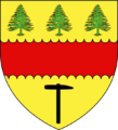
Coat of arms of Chibougamau
See also
 In Spanish: Chibougamau para niños
