Matherville, Illinois facts for kids
Quick facts for kids
Matherville, Illinois
|
|
|---|---|

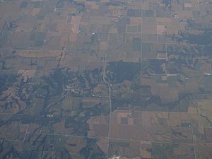
2012 aerial photo of Matherville
|
|

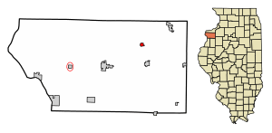
Location in Mercer County, Illinois
|
|
| Country | United States |
| State | Illinois |
| County | Mercer |
| Township | Preemption |
| Area | |
| • Total | 0.40 sq mi (1.03 km2) |
| • Land | 0.39 sq mi (1.01 km2) |
| • Water | 0.01 sq mi (0.02 km2) |
| Elevation | 750 ft (230 m) |
| Population
(2020)
|
|
| • Total | 707 |
| • Density | 1,808.18/sq mi (698.12/km2) |
| Time zone | UTC-6 (CST) |
| • Summer (DST) | UTC-5 (CDT) |
| ZIP code |
61263
|
| Area code(s) | 309 |
| FIPS code | 17-47527 |
| Wikimedia Commons | Matherville, Illinois |
Matherville is a small village located in Mercer County, Illinois, in the United States. In 2020, about 707 people lived there.
Contents
Where is Matherville Located?
Matherville is in the northeastern part of Mercer County. It is about 5 miles north of Viola and 11 miles northeast of Aledo. Aledo is the main town and county seat of Mercer County.
Land and Water Around Matherville
According to the U.S. Census Bureau, Matherville covers about 0.40 square miles (1.03 square kilometers). Most of this area is land, with only a tiny bit (about 0.01 square miles or 0.02 square kilometers) being water.
The village is built on a hillside. Water from this area flows south towards the Edwards River. The Edwards River then flows west and joins the Mississippi River. There is also a small lake called Lake Matherville in the northwest part of the village.
Who Lives in Matherville?
| Historical population | |||
|---|---|---|---|
| Census | Pop. | %± | |
| 1920 | 886 | — | |
| 1930 | 399 | −55.0% | |
| 1940 | 565 | 41.6% | |
| 1950 | 590 | 4.4% | |
| 1960 | 612 | 3.7% | |
| 1970 | 699 | 14.2% | |
| 1980 | 793 | 13.4% | |
| 1990 | 708 | −10.7% | |
| 2000 | 772 | 9.0% | |
| 2010 | 723 | −6.3% | |
| 2020 | 707 | −2.2% | |
| U.S. Decennial Census | |||
In the year 2000, there were 772 people living in Matherville. These people lived in 290 households, and 216 of those were families. The village had about 1,968 people per square mile.
Most people living in Matherville in 2000 were White (98.45%). A small number were Asian (0.26%), from other races (0.52%), or from two or more races (0.78%). About 1.04% of the people were Hispanic or Latino.
Households and Families
Many households in Matherville had children under 18 living with them (45.2%). More than half of the households (55.5%) were married couples living together. About 15.2% of households had a female head with no husband present.
The average household had 2.66 people, and the average family had 3.06 people.
Age and Income
In 2000, about 32.4% of the people in Matherville were under 18 years old. About 11.0% were 65 years or older. The average age of people in the village was 32 years.
The median household income (the middle income for all households) was $33,438. For families, the median income was $39,375. The average income per person in the village was $14,956.
About 15.8% of all people in Matherville lived below the poverty line. This included 24.5% of those under 18 and 4.0% of those 65 or older.
Library Services
Matherville is part of the Sherrard Public Library District. A special library bus, called a bookmobile, visits Matherville once a week. It stops at the Old School Park, making it easy for everyone to borrow books and other materials.
See also

- In Spanish: Matherville para niños
 | Frances Mary Albrier |
 | Whitney Young |
 | Muhammad Ali |


