
Mathrafal facts for kids

Location in Wales
|
|
| Location | Near Welshpool |
|---|---|
| Region | Powys, Wales |
| Coordinates | 52°41′17″N 3°17′15″W / 52.68806°N 3.28750°W |
| Type | Motte and Bailey Castle |
| Part of | Capital of the Kingdom of Powys until 1160, then of Powys Wenwynwyn until 1212. |
| Length | 90 m |
| Width | 80 m |
| History | |
| Founded | 9th century |
| Abandoned | 1212 |
| Periods | Medieval |
| Associated with | Bleddyn ap Cynfyn Gwenwynwyn ap Owain |
| Site notes | |
| Excavation dates | 1991 |
| Archaeologists | University of York |
| Condition | Ruin - mainly earthworks remaining |
Mathrafal is an ancient site near Welshpool in Powys, Mid Wales. For many years, it was the main home and power center for the Kings and Princes of Powys. This important place was likely used from the 9th century until it was destroyed in 1213 by Prince Llywelyn the Great.
Contents
Where is Mathrafal Located?
Mathrafal is found by the River Banwy. It sits just above where the Banwy river meets the river Vyrnwy. You can find it about 5 kilometers (3 miles) northeast of Llanfair Caereinion. It is also about 10 kilometers (6 miles) northwest of Welshpool. The site is right by the A495 road, where it joins with the B4389.
What Does Mathrafal Look Like Today?
The place we now call "Mathrafal Castle" is a large area, about 90 meters long and 80 meters wide. It was protected by a raised bank and a ditch on three sides. The fourth side was naturally protected by the river. Not much of the original walls are left today. Mostly, you can see the earthworks, which are the shapes made by the old banks and ditches.


Mathrafal's Role as a Capital City
Mathrafal was the first capital of the Kingdom of Powys. It was located in a region called Caereinion. A "cantref" was like a small district in medieval Wales.
In 1160, the Kingdom of Powys was divided into two parts. Mathrafal then became the capital of the southern part. This southern kingdom later became known as Powys Wenwynwyn.
The History of Mathrafal Castle
The castle structure you see today likely replaced an even older fort. This older fort was a "hill fort," built on a high place for defense. It was about 1 kilometer away to the northwest.
This older fort might have been built around 656. This was when the nearby Kingdom of Pengwern fell. Or, it could be as old as 520. That's when the capital of Powys moved from the old Roman town of Viroconium Cornoviorum (now Wroxeter).
The main part of Mathrafal Castle is a "motte." A motte is a large mound of earth. This one is 35 meters long, 25 meters wide, and 5 meters high. This motte was built around the late 12th century.
It was probably built by Owain Cyfeiliog around 1170. Or, it might have been built by Robert de Vieuxpont for King John in 1212.
Why Was Mathrafal Abandoned?
Prince Gwenwynwyn ab Owain of Powys decided to move his capital. He moved it from Mathrafal to Welshpool (called Y Trallwng in Welsh) in 1212.
Later in 1212, Robert de Vieuxpont was trapped inside the castle. He was surrounded by the armies of Gwenwynwyn and Llywelyn the Great. King John had to rescue him. After this, the castle was destroyed and never rebuilt.
What Did Archaeologists Find?
In 1991, archaeologists from the University of York dug at the site. They found an interesting iron and bronze statue. It was a figurine of St Gwynllyw, also known as Woolos the Warrior. They found it hidden in a small space in a window base.
Images for kids
-
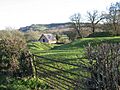
Entry to the earthworks and a view towards the motte
-
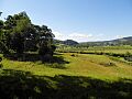
A view from the motte
