Maxwell, Nebraska facts for kids
Quick facts for kids
Maxwell, Nebraska
|
|
|---|---|
|
Village
|
|

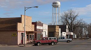
Downtown Maxwell, as viewed from
Nebraska Spur 56A, March 2012 |
|

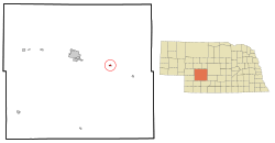
Location of Maxwell, Nebraska
|
|
| Country | United States |
| State | Nebraska |
| County | Lincoln |
| Area | |
| • Total | 0.46 sq mi (1.20 km2) |
| • Land | 0.46 sq mi (1.20 km2) |
| • Water | 0.00 sq mi (0.00 km2) |
| Elevation | 2,713 ft (827 m) |
| Population
(2020)
|
|
| • Total | 257 |
| • Density | 555.08/sq mi (214.19/km2) |
| Time zone | UTC-6 (Central (CST)) |
| • Summer (DST) | UTC-5 (CDT) |
| ZIP code |
69151
|
| Area code(s) | 308 |
| FIPS code | 31-31220 |
| GNIS feature ID | 2399277 |
Maxwell is a small village located in Lincoln County, Nebraska, United States. It is part of the North Platte Micropolitan Statistical Area, which is a group of communities connected by jobs and daily life. In 2010, the village had a population of 312 people. By 2020, the population was 257.
Contents
History of Maxwell Village
Maxwell was officially planned and mapped out in 1894. This happened after the Union Pacific Railroad built its tracks to reach this area. The village was named after an important official who worked for the railroad company. Later, in 1908, Maxwell became an officially recognized village.
On May 17, 2000, a very strong tornado hit Maxwell. It was classified as an F3 tornado on the Fujita scale, which means it caused significant damage.
Where is Maxwell Located?
According to the United States Census Bureau, Maxwell covers a total area of about 0.34 square miles (0.88 square kilometers). All of this area is land, meaning there are no large bodies of water like lakes or rivers within the village limits.
Who Lives in Maxwell?
| Historical population | |||
|---|---|---|---|
| Census | Pop. | %± | |
| 1910 | 289 | — | |
| 1920 | 410 | 41.9% | |
| 1930 | 409 | −0.2% | |
| 1940 | 480 | 17.4% | |
| 1950 | 347 | −27.7% | |
| 1960 | 324 | −6.6% | |
| 1970 | 282 | −13.0% | |
| 1980 | 410 | 45.4% | |
| 1990 | 285 | −30.5% | |
| 2000 | 315 | 10.5% | |
| 2010 | 312 | −1.0% | |
| 2020 | 257 | −17.6% | |
| U.S. Decennial Census | |||
Population in 2010
In 2010, the village of Maxwell had 312 residents living in 121 households. Out of these, 87 were families. The village had about 917.6 people per square mile. There were 133 housing units in total.
Most of the people living in Maxwell were White, making up 96.5% of the population. A small number were African American (0.6%) or Native American (1.0%). About 1.0% were from other racial backgrounds, and 1.0% identified with two or more races. People of Hispanic or Latino background made up 2.6% of the population.
Many households (39.7%) had children under 18 living with them. More than half (55.4%) were married couples. About 6.6% of households were led by a female without a husband, and 9.9% by a male without a wife. Roughly 28.1% of households were not families. About a quarter (24.8%) of all households had only one person living in them. And 12.4% of households had someone aged 65 or older living alone. On average, there were 2.58 people per household and 3.06 people per family.
The average age of people in Maxwell was 38.6 years. About 27.9% of residents were under 18 years old. About 7.3% were between 18 and 24 years old. People aged 25 to 44 made up 24.1% of the population. Those aged 45 to 64 were 26%. Finally, 14.7% of the population was 65 years old or older. The village had slightly more females (50.6%) than males (49.4%).
See also
 In Spanish: Maxwell (Nebraska) para niños
 | Jackie Robinson |
 | Jack Johnson |
 | Althea Gibson |
 | Arthur Ashe |
 | Muhammad Ali |

