Maynard, Iowa facts for kids
Quick facts for kids
Maynard, Iowa
|
|
|---|---|

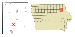
Location of Maynard, Iowa
|
|
| Country | |
| State | |
| County | Fayette |
| Area | |
| • Total | 0.99 sq mi (2.58 km2) |
| • Land | 0.97 sq mi (2.51 km2) |
| • Water | 0.03 sq mi (0.07 km2) |
| Elevation | 1,106 ft (337 m) |
| Population
(2020)
|
|
| • Total | 476 |
| • Density | 491.23/sq mi (189.71/km2) |
| Time zone | UTC-6 (Central (CST)) |
| • Summer (DST) | UTC-5 (CDT) |
| ZIP code |
50655
|
| Area code(s) | 563 |
| FIPS code | 19-50610 |
| GNIS feature ID | 0458870 |
Maynard is a city in Fayette County, Iowa, United States. It is a small community located in the northeastern part of Iowa. In 2020, the city had a population of 476 people.
Contents
Geography of Maynard
Maynard is located in Iowa at coordinates 42°46′28″N 91°52′42″W / 42.77444°N 91.87833°W. It sits along the Little Volga River.
The city covers a total area of about 1.02 square miles (2.64 km2). Most of this area, about 0.99 square miles (2.56 km2), is land. A small part, about 0.03 square miles (0.08 km2), is water.
Population and Demographics
Maynard's population has changed over the years. Here is a look at how many people have lived in the city:
| Historical populations | ||
|---|---|---|
| Year | Pop. | ±% |
| 1880 | 270 | — |
| 1890 | 371 | +37.4% |
| 1900 | 495 | +33.4% |
| 1910 | 382 | −22.8% |
| 1920 | 387 | +1.3% |
| 1930 | 409 | +5.7% |
| 1940 | 432 | +5.6% |
| 1950 | 455 | +5.3% |
| 1960 | 515 | +13.2% |
| 1970 | 503 | −2.3% |
| 1980 | 561 | +11.5% |
| 1990 | 513 | −8.6% |
| 2000 | 500 | −2.5% |
| 2010 | 518 | +3.6% |
| 2020 | 476 | −8.1% |
| Source: and Iowa Data Center Source: |
||
Maynard's Population in 2020
According to the 2020 census, 476 people lived in Maynard. There were 212 households and 127 families. The city had about 491 people per square mile.
Most residents, about 93.9%, were White. A small number of people belonged to other racial groups. About 2.7% of the population identified as Hispanic or Latino.
About 25% of households had children under 18 living with them. The average age of people in Maynard was 42.5 years old. About 26.3% of residents were under 20 years old.
Maynard's Population in 2010
In the 2010 census, Maynard had 518 residents. There were 228 households and 141 families. The population density was about 523 people per square mile.
Most people in 2010, about 98.6%, were White. About 2.5% of the population was Hispanic or Latino.
About 29.8% of households had children under 18. The median age was 42.8 years. About 24.1% of residents were under 18 years old.
Education in Maynard
Maynard is home to the West Central Community School District. This district manages the public schools in the area. The schools also take part in sports competitions through the Upper Iowa Conference.
See also
 In Spanish: Maynard (Iowa) para niños
 | Georgia Louise Harris Brown |
 | Julian Abele |
 | Norma Merrick Sklarek |
 | William Sidney Pittman |

