McAdoo, Pennsylvania facts for kids
Quick facts for kids
McAdoo, Pennsylvania
|
|
|---|---|
|
Borough
|
|

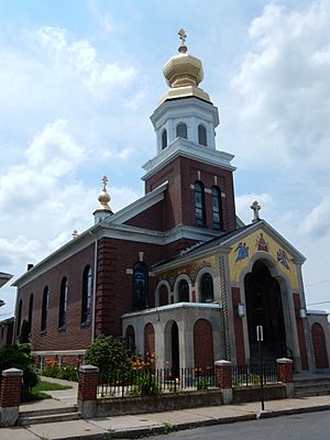
St. Mary's Ukrainian Catholic Church.
|
|

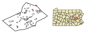
Location of McAdoo in Schuylkill County, Pennsylvania.
|
|
| Country | United States |
| State | Pennsylvania |
| County | Schuylkill |
| Incorporated | 1896 |
| Government | |
| • Type | Borough Council |
| Area | |
| • Total | 0.35 sq mi (0.90 km2) |
| • Land | 0.35 sq mi (0.90 km2) |
| • Water | 0.00 sq mi (0.00 km2) |
| Population
(2020)
|
|
| • Total | 2,471 |
| • Density | 7,121.04/sq mi (2,750.06/km2) |
| Time zone | UTC−05:00 (EST) |
| • Summer (DST) | UTC−04:00 (EDT) |
| ZIP Code |
18237
|
| Area code(s) | 570 |
| FIPS code | 42-45824 |
McAdoo is a small town, also called a borough, located in Schuylkill County, Pennsylvania. It's about 5 miles (8 km) south of Hazleton. In the past, McAdoo was known as a coal town because of its anthracite coal mines. There was also a shirt factory, the McAdoo Manufacturing Company, which provided jobs for many people. In 2020, about 2,477 people lived in McAdoo.
Contents
Exploring McAdoo's Location and Climate
McAdoo covers a total area of about 0.3 square miles (0.9 square kilometers), and all of it is land. The town sits high up, about 1,700 feet (518 meters) above sea level. It's located on top of Broad Mountain. This means it's on a special line where water flows in two different directions: some water goes towards the Delaware River and some towards the Susquehanna River.
Main Roads and Travel
The main road that goes through McAdoo from north to south is Pennsylvania Route 309 (also known as Kennedy Drive). Another big highway, Interstate 81, runs a short distance west of town. You can easily get to Interstate 81 from McAdoo using an access road just south of the town.
Weather in McAdoo
McAdoo has a warm-summer humid continental climate. This means it has warm summers and cold winters. The average temperature in January is around 23.5°F (-4.7°C), and in July, it's about 70.1°F (21.2°C).
People of McAdoo: A Look at the Population
| Historical population | |||
|---|---|---|---|
| Census | Pop. | %± | |
| 1900 | 2,122 | — | |
| 1910 | 3,389 | 59.7% | |
| 1920 | 4,674 | 37.9% | |
| 1930 | 5,239 | 12.1% | |
| 1940 | 5,127 | −2.1% | |
| 1950 | 4,260 | −16.9% | |
| 1960 | 3,560 | −16.4% | |
| 1970 | 3,326 | −6.6% | |
| 1980 | 2,940 | −11.6% | |
| 1990 | 2,459 | −16.4% | |
| 2000 | 2,274 | −7.5% | |
| 2010 | 2,300 | 1.1% | |
| 2020 | 2,477 | 7.7% | |
| 2021 (est.) | 2,476 | 7.7% | |
| Sources: | |||
In 2000, there were 2,274 people living in McAdoo. Most of the people were White (99.47%). A small number were African American, Native American, or Asian. About 0.66% of the population was Hispanic or Latino.
Family Life and Age Groups
In 2000, about 23.8% of the homes in McAdoo had children under 18 living there. Many homes (42.5%) were married couples. About 20.6% of the population was under 18 years old. The median age in McAdoo was 41 years old. This means half the people were younger than 41 and half were older.
Learning and Schools in McAdoo
The schools in McAdoo are part of the Hazleton Area School District. The district operates the McAdoo-Kelayres Elementary-Middle School, which serves students from McAdoo and a nearby place called Kelayres. When students are ready for high school, they attend the Hazleton Area High School in Hazle Township.
Getting Around: Transportation in McAdoo
McAdoo has public transportation options. The STS bus route 45 connects McAdoo to Pottsville, passing through Tamaqua. On Wednesdays, there's a special bus, route 47, that runs from Pottsville to Hometown and McAdoo, going through other towns like Frackville and Shenandoah. The Hazleton Public Transit also has bus route 20, which goes through McAdoo to Kelayres.
Images for kids
See also
 In Spanish: McAdoo (Pensilvania) para niños


