McCausland, Iowa facts for kids
Quick facts for kids
McCausland, Iowa
|
|
|---|---|
|
City
|
|
 |
|

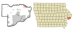
Location of McCausland, Iowa
|
|
| Country | United States |
| State | |
| County | Scott |
| Area | |
| • City | 0.58 sq mi (1.50 km2) |
| • Land | 0.55 sq mi (1.44 km2) |
| • Water | 0.02 sq mi (0.06 km2) |
| Elevation | 610 ft (186 m) |
| Population
(2020)
|
|
| • City | 313 |
| • Density | 564.98/sq mi (217.96/km2) |
| • Metro | 381,342 (134th) |
| Time zone | UTC-6 (Central (CST)) |
| • Summer (DST) | UTC-5 (CDT) |
| ZIP code |
52758
|
| Area code(s) | 563 |
| FIPS code | 19-47820 |
| GNIS feature ID | 0458887 |
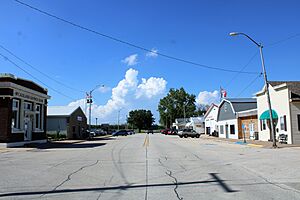
McCausland is a small city in Scott County, Iowa, United States. It is located in Butler Township. In 2020, the city had a population of 313 people.
The city was started in 1882 by D.C. McCausland. He was a landowner and also traded horses.
Contents
Geography of McCausland
McCausland is located in eastern Iowa. Its exact coordinates are 41.744804 degrees North and 90.442613 degrees West.
Area and Land Use
According to the United States Census Bureau, the city covers a total area of about 0.56 square miles (1.45 square kilometers). Most of this area, about 0.54 square miles (1.40 square kilometers), is land. A very small part, about 0.02 square miles (0.05 square kilometers), is water.
People of McCausland
| Historical populations | ||
|---|---|---|
| Year | Pop. | ±% |
| 1910 | 106 | — |
| 1920 | 110 | +3.8% |
| 1930 | 104 | −5.5% |
| 1940 | 115 | +10.6% |
| 1950 | 150 | +30.4% |
| 1960 | 173 | +15.3% |
| 1970 | 226 | +30.6% |
| 1980 | 381 | +68.6% |
| 1990 | 308 | −19.2% |
| 2000 | 299 | −2.9% |
| 2010 | 291 | −2.7% |
| 2020 | 313 | +7.6% |
| Source: and Iowa Data Center Source: |
||
2020 Population Details
In 2020, the city had 313 residents. There were 118 households and 92 families living in McCausland. The population density was about 564.5 people per square mile.
Most of the people living in McCausland were White (93.9%). About 1.3% of the population was Hispanic or Latino.
Households and Age
Out of 118 households, about 35.6% had children under 18 years old. Most households (60.2%) were married couples living together.
The average age of people in McCausland was 38.9 years. About 27.2% of residents were under 20 years old. People aged 65 or older made up 16.0% of the population. The city had slightly more males (52.7%) than females (47.3%).
2010 Population Details
In 2010, McCausland had 291 residents. There were 115 households and 86 families. The population density was about 538.9 people per square mile.
Most residents (97.9%) were White. About 1.7% of the population was Hispanic or Latino.
Households and Age in 2010
About 36.5% of households had children under 18. Most households (66.1%) were married couples.
The average age in 2010 was 40.1 years. About 22.3% of residents were under 18. People aged 65 or older made up 12.7% of the population. The city had a nearly even split of males (49.8%) and females (50.2%).
Education in McCausland
McCausland is part of the North Scott Community School District. This school district covers about 220 square miles (570 square kilometers) in the northern part of Scott County.
See also
 In Spanish: McCausland (Iowa) para niños
 | Emma Amos |
 | Edward Mitchell Bannister |
 | Larry D. Alexander |
 | Ernie Barnes |


