McCoy, Colorado facts for kids
Quick facts for kids
McCoy, Colorado
|
|
|---|---|

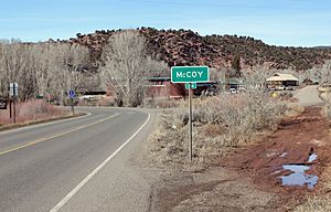
Entering McCoy
|
|

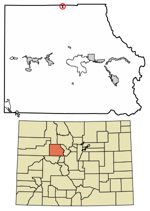
Location of the McCoy CDP in Eagle County, Colorado.
|
|
| Country | |
| State | |
| County | Eagle County |
| Area | |
| • Total | 0.294 sq mi (0.761 km2) |
| • Land | 0.294 sq mi (0.761 km2) |
| • Water | 0 sq mi (0.000 km2) |
| Elevation | 6,683 ft (2,037 m) |
| Population
(2020)
|
|
| • Total | 30 |
| • Density | 102/sq mi (39/km2) |
| Time zone | UTC-7 (MST) |
| • Summer (DST) | UTC-6 (MDT) |
| ZIP Code |
80463
|
| Area code(s) | 970 |
| GNIS feature | 2583263 |
McCoy is a small community in Eagle County, Colorado, United States. It's known as an unincorporated town and a census-designated place (CDP). This means it's a recognized community but doesn't have its own local government like a city or town would. McCoy also has its own post office! In 2020, only 30 people lived in McCoy.
Contents
Where is McCoy?
McCoy is located in the northern part of Eagle County, Colorado. It sits in a valley near Rock Creek, which flows into the Colorado River. Imagine a map of Colorado; McCoy is nestled among the mountains.
Getting Around McCoy
A main road, Colorado State Highway 131, goes right through McCoy. This highway can take you south about 20 miles to Interstate 70 at Wolcott, Colorado. If you head north on Highway 131, you'll reach Steamboat Springs, Colorado in about 52 miles.
How Big is McCoy?
The area of McCoy is quite small. It covers about 0.761 square kilometers (which is about 0.29 square miles). All of this area is land, with no large bodies of water inside its borders.
A Look Back in Time
The history of McCoy dates back to the late 1800s. The McCoy Post Office first opened its doors in 1891. The community was named after a man named Charles H. McCoy, who was a cattleman. He likely played an important role in the early days of the area.
Who Lives in McCoy?
The United States Census Bureau keeps track of how many people live in different places. They first counted McCoy as a census-designated place for the 2010 census.
| McCoy CDP, Colorado | ||
|---|---|---|
| Year | Pop. | ±% |
| 2010 | 24 | — |
| 2020 | 30 | +25.0% |
| Source: United States Census Bureau | ||
As you can see, the population of McCoy grew a little bit between 2010 and 2020. In 2010, there were 24 people, and by 2020, there were 30 residents.
See also
 In Spanish: McCoy (Colorado) para niños


