McGrath, Minnesota facts for kids
Quick facts for kids
McGrath, Minnesota
|
|
|---|---|

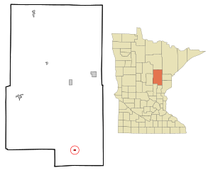
Location of the city of McGrath
within Aitkin County, Minnesota |
|
| Country | United States |
| State | Minnesota |
| County | Aitkin |
| Incorporated | March 23, 1923 |
| Area | |
| • Total | 0.371 sq mi (0.961 km2) |
| • Land | 0.371 sq mi (0.961 km2) |
| • Water | 0.000 sq mi (0.000 km2) |
| Elevation | 1,234 ft (376 m) |
| Population
(2020)
|
|
| • Total | 41 |
| • Estimate
(2022)
|
42 |
| • Density | 110.51/sq mi (42.67/km2) |
| Time zone | UTC−6 (Central (CST)) |
| • Summer (DST) | UTC−5 (CDT) |
| ZIP Code |
56350
|
| Area code(s) | 320 |
| FIPS code | 27-38996 |
| GNIS feature ID | 2395067 |
| Sales tax | 6.875% |
McGrath is a small city in Aitkin County, Minnesota, United States. In 2020, about 41 people lived there. It's a quiet place with a rich history.
Contents
History of McGrath
The city of McGrath got its start thanks to a man named James E. McGrath. He was a logger, someone who cuts down trees for wood. James had been working in this area since 1895.
In 1907, he gave 40 acres (about 16 hectares) of his land to create a town. This new town was first called Elmwood. A year later, in 1908, a post office was opened there. The town was then renamed McGrath, honoring James E. McGrath. The city officially became a town in 1923.
Geography of McGrath
McGrath is a small city, covering an area of about 0.371 square miles (0.961 square kilometers). All of this area is land.
The city is located right along two main roads: Minnesota State Highway 27 and Minnesota State Highway 65. These two highways share the same path through McGrath. Another state highway, Minnesota State Highway 18, is also close by. Other local roads include Aitkin County Road 9 and 1st Street.
Nature is all around McGrath. The Snake River and Bear Creek both flow near the city. If you like outdoor adventures, the Soo Line ATV Trail is also nearby. This trail is great for riding all-terrain vehicles.
Population and People
| Historical population | |||
|---|---|---|---|
| Census | Pop. | %± | |
| 1930 | 141 | — | |
| 1940 | 138 | −2.1% | |
| 1950 | 135 | −2.2% | |
| 1960 | 96 | −28.9% | |
| 1970 | 70 | −27.1% | |
| 1980 | 81 | 15.7% | |
| 1990 | 62 | −23.5% | |
| 2000 | 65 | 4.8% | |
| 2010 | 80 | 23.1% | |
| 2020 | 41 | −48.7% | |
| 2022 (est.) | 42 | −47.5% | |
| U.S. Decennial Census 2020 Census |
|||
How Many People Live in McGrath?
The number of people living in McGrath has changed over the years. In 2010, there were 80 people living in the city. These people lived in 32 different homes, and 19 of those were families.
Most of the people living in McGrath in 2010 were White (96.3%). A small number were Native American (1.3%) or from two or more different backgrounds (2.5%).
Homes and Families
Out of the 32 homes in McGrath in 2010:
- About 15.6% had kids under 18 living there.
- Nearly half (46.9%) were married couples living together.
- A few homes (6.3%) had a female head of the house without a husband.
- Another few homes (6.3%) had a male head of the house without a wife.
- About 40.6% were not families, meaning individuals living alone or with roommates.
About 34.4% of all homes were made up of just one person. And 12.5% of homes had someone living alone who was 65 years old or older. On average, there were about 2 people in each home. For families, the average was about 2.8 people.
Age of Residents
In 2010, the average age of people in McGrath was 51 years old.
- About 11.2% of residents were under 18 years old.
- About 5.2% were between 18 and 24 years old.
- About 23.8% were between 25 and 44 years old.
- About 30.1% were between 45 and 64 years old.
- About 30% were 65 years old or older.
More males lived in McGrath than females in 2010. About 58.8% of the population was male, and 41.3% was female.
See also
 In Spanish: McGrath (Minnesota) para niños

