McKenney, Virginia facts for kids
Quick facts for kids
McKenney, Virginia
|
|
|---|---|

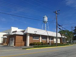
Central McKenney, April 2017
|
|
| Country | United States |
| State | Virginia |
| County | Dinwiddie |
| Area | |
| • Total | 0.93 sq mi (2.40 km2) |
| • Land | 0.93 sq mi (2.40 km2) |
| • Water | 0.00 sq mi (0.00 km2) |
| Elevation | 335 ft (102 m) |
| Population
(2010)
|
|
| • Total | 483 |
| • Estimate
(2019)
|
489 |
| • Density | 526.94/sq mi (203.49/km2) |
| Time zone | UTC−5 (Eastern (EST)) |
| • Summer (DST) | UTC−4 (EDT) |
| ZIP code |
23872
|
| Area code(s) | 804 |
| FIPS code | 51-48344 |
| GNIS feature ID | 1495918 |
McKenney is a small town located in Dinwiddie County, Virginia, in the United States. It is an incorporated town, which means it has its own local government. According to the 2010 census, about 483 people lived there.
History of McKenney
McKenney grew up along a major railroad line. The Richmond, Petersburg and Carolina Railroad was finished in 1900. This railroad connected McKenney to cities like Petersburg, Virginia. Later, this line became part of the Seaboard Air Line. By 1914, McKenney had about 300 residents.
The railroad line, sometimes called the "S-line," operated until the 1980s. After that, it was no longer used. This means McKenney is now a bit more isolated without the train service.
Several important historical places in or near McKenney are listed on the National Register of Historic Places. These include Montrose, the Sappony Church, and Zehmer Farm. A historical marker near McKenney also honors Sallie Jones Atkinson. She was an important educator.
Geography of McKenney
McKenney is located in the southwestern part of Dinwiddie County. You can find it at 36°59′00″N 77°43′08″W / 36.983307°N 77.718810°W.
Major roads pass near the town. U.S. Route 1 goes through the southeast side of McKenney. Interstate 85 is also very close, with an exit (Exit 42) that leads to the town. Using these highways, it's about 26 miles (42 km) northeast to Petersburg. It's also about 30 miles (48 km) southwest to South Hill. Virginia State Route 40 runs through the center of McKenney. This road goes east about 18 miles (29 km) to Stony Creek. It also goes northwest about 20 miles (32 km) to Blackstone.
The United States Census Bureau says that McKenney covers a total area of about 0.93 square miles (2.4 square kilometers). All of this area is land.
People of McKenney
| Historical population | |||
|---|---|---|---|
| Census | Pop. | %± | |
| 1930 | 341 | — | |
| 1940 | 453 | 32.8% | |
| 1950 | 476 | 5.1% | |
| 1960 | 519 | 9.0% | |
| 1970 | 489 | −5.8% | |
| 1980 | 473 | −3.3% | |
| 1990 | 386 | −18.4% | |
| 2000 | 441 | 14.2% | |
| 2010 | 483 | 9.5% | |
| 2019 (est.) | 489 | 1.2% | |
| U.S. Decennial Census | |||
In the year 2000, 441 people lived in McKenney. There were 167 households, which are groups of people living together. Out of these, 105 were families. The town had about 465 people per square mile (179 per square kilometer).
Most people in McKenney were White (66.21%). About 33.33% were African American. A very small number were Asian (0.23%) or from two or more races (0.23%). About 2.04% of the population was Hispanic or Latino.
About 26.3% of households had children under 18 living with them. Many households (44.9%) were married couples living together. Some households (15.6%) had a female head with no husband present. About 32.3% of all households were made up of individuals living alone. This included 15.6% of people aged 65 or older living by themselves. The average household had 2.43 people. The average family had 3.11 people.
The population in McKenney was spread out by age. About 20.6% were under 18 years old. About 7.5% were between 18 and 24. The largest group, 27.2%, was between 25 and 44. People aged 45 to 64 made up 25.9%. About 18.8% of the population was 65 years or older. The average age in the town was 42 years.
See also
 In Spanish: McKenney (Virginia) para niños


