McKinley, Taylor County, Wisconsin facts for kids
Quick facts for kids
McKinley, Wisconsin
|
|
|---|---|

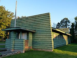
The McKinley town hall is on the National Register of Historic Places because it was designed by noted Prairie School architects Purcell & Elmslie.
|
|

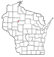
Location of McKinley, Taylor County, Wisconsin
|
|
| Country | |
| State | |
| County | Taylor |
| Area | |
| • Total | 35.8 sq mi (92.8 km2) |
| • Land | 35.7 sq mi (92.6 km2) |
| • Water | 0.1 sq mi (0.2 km2) |
| Elevation | 1,188 ft (362 m) |
| Population
(2000)
|
|
| • Total | 418 |
| • Density | 11.7/sq mi (4.5/km2) |
| Time zone | UTC-6 (Central (CST)) |
| • Summer (DST) | UTC-5 (CDT) |
| Area code(s) | 715 & 534 |
| FIPS code | 55-46925 |
| GNIS feature ID | 1583622 |
| PLSS township | T33N R4W |
McKinley is a small town in Taylor County, Wisconsin, in the United States. In 2000, about 418 people lived there. Part of the community called Jump River is also in McKinley.
Contents
History of McKinley
Early Land Surveys
The first European Americans to explore the area that would become McKinley were government surveyors. They walked the land in 1847, mapping its outer edges. In 1855, they returned to map all the smaller sections within the town.
After their work, a surveyor described the area. He noted many swamps that were not good for farming. He also mentioned "Meadow and Alder Bottoms" that would flood but were good for Hay. The higher land had decent soil.
The area was heavily forested with trees like Hemlock, Yellow Birch, Balsam, and White Pine. The Jump River flowed through the area, with a fast current. This current could be used to power mills. At that time, there were no buildings or farms in the township.
First Land Owners
The U.S. government first gave out land in McKinley in 1860. Four pieces of land, each 160 acres, were given along the Jump River. These went to Belinda Bonesteel and Harrison Hobart. They received this land as payment for the descendants of Native American soldiers. These soldiers had served in the Black Hawk War about 30 years earlier.
A very large landowner was Ezra Cornell. He received many half-sections of land in McKinley in 1868 and 1869. This land helped pay for the new Cornell University. This was part of a program to fund colleges that taught farming and mechanical arts.
Mapping the Area
Around 1888, a map of the McKinley area showed no roads and no settlers. Most of the land was owned by private companies or individuals. The biggest owners were Cornell University and lumber companies.
Forming the Town
In 1902, the town of McKinley was officially created. It was separated from a larger town called Westboro. This new McKinley included what are now the towns of McKinley and Jump River. In 1923, the town of Jump River became its own separate town. This left McKinley with its current borders.
The Railroad Arrives
Around 1904, McKinley got an important connection to the outside world. The Stanley, Merrill and Phillips Railroad built tracks through the eastern part of the town. The tracks followed the river down to Jump River.
With the railroad, the Northwestern Lumber Company began cutting down trees. They built temporary railroad lines to reach logging camps. One line, called Spur 5, went east of Sunnyside Road to the Jump River. Another line, Spur 4, went north of the river. By 1906, a train from Stanley would pass through McKinley every day except Sunday.
A Village That Wasn't
In 1906, a developer named T.H. Field tried to create a village called Field. It was planned to be across the river and railroad from the new community of Jump River. He mapped out the town and even started a post office, a hotel, some homes, and a sawmill. However, the railroad would not stop on his side of the river. Because of this, his dream of a new village never really took off.
By 1911, a new map showed only a few roads in McKinley. Some settlers had homes along the river and Buckhorn Road. Most of the land was still owned by lumber companies. This shows that McKinley was settled later than other areas in Wisconsin.
Geography and Landscape
McKinley covers about 35.8 square miles (92.8 square kilometers). Most of this area is land, with only a small part being water.
The Jump River, Alder Creek, and Shoulder Creek all flow through the town. They generally move from east to west. North of the Jump River, the land has low ridges. These might be drumlins, which are hills left behind by glaciers. Or they could be caused by the rock formations under the glacial till (rock and soil left by glaciers). South of the river, the land is gently rolling. It also has some hills and areas with heavier soil.
There are also several man-made ponds or small lakes. These are located in the Pershing Wildlife Area, on the southern edge of the town.
Population and People
In the year 2000, McKinley had 418 people living there. There were 139 households, and 104 of these were families. On average, there were about 11.7 people per square mile. Most of the people living in McKinley (99.76%) were white.
About 37.4% of the households had children under 18 living with them. Most households (61.9%) were married couples living together. About 19.4% of households were single people living alone. Some of these were people aged 65 or older.
The population was spread out by age. About 34.4% of the people were under 18 years old. About 12.7% were 65 years or older. The average age in McKinley was 34 years. For every 100 females, there were about 103 males.
The average income for a household in McKinley was $36,528. For families, the average income was $43,906. About 6.7% of families and 13.3% of all people lived below the poverty line. This included 17.6% of those under 18.
See also
 In Spanish: McKinley (condado de Taylor, Wisconsin) para niños
 | Laphonza Butler |
 | Daisy Bates |
 | Elizabeth Piper Ensley |

