
Westboro, Wisconsin facts for kids
Quick facts for kids
Westboro, Wisconsin
|
|
|---|---|

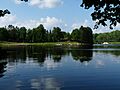
Much of the town is wild national forest land – wooded hills sprinkled with bogs and little lakes, like this one along CTH D.
|
|

Location of Westboro, Wisconsin
|
|
| Country | |
| State | |
| County | Taylor |
| Area | |
| • Total | 125.4 sq mi (324.9 km2) |
| • Land | 124.1 sq mi (321.4 km2) |
| • Water | 1.3 sq mi (3.5 km2) |
| Elevation | 1,473 ft (449 m) |
| Population
(2000)
|
|
| • Total | 660 |
| • Density | 5.3/sq mi (2.1/km2) |
| Time zone | UTC-6 (Central (CST)) |
| • Summer (DST) | UTC-5 (CDT) |
| Area code(s) | 715 & 534 |
| FIPS code | 55-85450 |
| GNIS feature ID | 1584401 |
| PLSS township | T33N R2W, T33N R1W, T33N R1E, and part of T33N R2E |
| Website | http://townofwestboro.com |
Westboro is a town located in Taylor County, Wisconsin, in the United States. In the year 2000, about 660 people lived there. The area known as Westboro is part of this larger town. Another small community called Queenstown is also found within the town's borders.
Contents
Geography of Westboro
Westboro is the biggest town in Taylor County. It's much larger than a typical town, stretching about six miles wide and twenty miles long. The United States Census Bureau says the town covers about 125.4 square miles (324.9 square kilometers). Most of this area, about 124.1 square miles (321.4 square kilometers), is land. The rest, about 1.3 square miles (3.5 square kilometers), is water.
Natural Areas in Westboro
Westboro is home to three special natural areas in Taylor County. These are places protected for their unique plants and animals. They include Kidrick Swamp SNA, Silver Creek & Mondeaux River SNA, and a part of Mondeaux Hardwoods SNA.
History of Westboro
The story of Westboro began a long time ago. In 1847, government surveyors explored the land. They used tools like a compass and a chain to measure and map out the area. These measurements helped create the boundaries of what would become the town of Westboro.
Early Land Surveys
In 1858, another group of surveyors returned to map all the smaller sections of land. After their work, they wrote descriptions of each six-mile square area. One description of west-central Westboro (T33N R1W) said the land had some small swamps with Tamarac and Cedar trees. It also mentioned rolling hills and good soil. The main trees were Hemlock, Birch, Maple, and Pine.
The report also noted a large area where trees had been blown down by wind. This area was growing back with new Poplar trees. Several creeks flowed through the area, including the Yellow River. This river was deep and narrow with a gentle flow.
A different surveyor in 1862 was very positive about the east-central part of Westboro. This is where most people live today. He wrote that this area had "splendid White Pine" trees and good soil. He also noted that the land was rolling and had heavy timber.
Railroads and Early Settlers
In the early 1870s, the Wisconsin Central Railroad Company built its train tracks through the forest. This line came up from Medford. To help pay for this, the railroad was given half of the land for 18 miles on both sides of the tracks. This usually included the odd-numbered sections of land.
The railroad created stations at places like Whittlesey, Chelsea, and the future village of Westboro. The first settlers arrived in 1874. When Taylor County was formed in 1875, the Town of Westboro was much larger than it is today. It stretched across the entire width of the county.
Logging and Growth
By 1878, John Duncan had a "pole line" tramway. This was a simple track made of hardwood saplings. Horses pulled carts loaded with logs along this track to his sawmill in Westboro.
By 1880, Westboro had a population of 230 people. The village itself had two sawmills, two stores, two hotels, three saloons, and a school. An 1880 map shows some roads. One went three miles east from town to James Lake. Another went two miles west, north of Silver Creek. This road then joined a "Winter Road." This was a special trail used by loggers to move supplies to their camps in winter. Loggers cut valuable white pine trees. In the spring, they would float the logs down Silver Creek and the Yellow River in what were called log drives.
In 1885, the town of Rib Lake was separated from the eastern part of Westboro.
Changes Around 1900
Around 1900, maps showed more homesteads (settler homes) along the railroad and roads. A new rail line was built from Chelsea towards Rib Lake. This track ran across the south end of Westboro and past Wellington Lake. A road, similar to modern Highway 102, ran next to this railroad, with settlers living along it.
Many settlers also built homes around Chelsea. A road zigzagged west of Shearer Lake, similar to modern Chelsea Avenue. Several rural schools were marked on these roads, showing where families lived. For example, one school was near where Gunnar Road meets Fischer Creek Road. Another was east of Westboro on what would become Lucia Road.
West of Westboro, another rural school was on an early version of Silver Creek Road. Further west, this road turned south, crossed Silver Creek, and then went west again for almost ten miles. A few homesteads were clustered there. Beyond that, the area was mostly undeveloped until the Broederville settlement on the Jump River, which was then part of Westboro.
Large parts of the land were owned by companies. The Wisconsin Central Railroad owned much of the area. J. Duncan owned land near his sawmill. Other companies like N. Wisconsin Land Company, Ramsay Land Company, and Yellow River Lumber Company also owned significant portions.
In 1902, the western twelve miles of Westboro were split off to form a new town called Town of McKinley. This new town included what is now the town of Jump River.
Early 20th Century Development
By 1911, plat maps showed even more roads and homesteads. In the east, near the railroad, some roads had been extended. Lumber company land was divided and sold to new settlers. A new logging railroad, the Westboro Logging Line, was built. This line was started in 1900 by the Heidrich and Matson Lumber Company. They had bought Duncan's sawmill and his timber.
In 1902, the Westboro Lumber Company bought Heidrich and Matson. The Westboro Logging Line eventually reached twelve miles west of Westboro. It crossed Mondeaux Creek and went to the north fork of the Yellow River. The 1911 map showed a new rural school and more settlers on what is now Heldstab Road. A few families settled near where the Jump River fire lookout would later be built, with another rural school nearby. The western part of the town was still mostly owned by companies, with the Wisconsin Central Railway and the Yellow River Lumber Company holding the largest shares.
In 1933, a large part of the western half of Westboro became part of the Chequamegon National Forest. This forest is a protected area. Starting that year, a Civilian Conservation Corps camp at Mondeaux helped create the Mondeaux Dam Recreation Area.
Population and People
The census of 2000 showed that 660 people lived in Westboro. These people lived in 261 households, and 179 of these were families. The population density was about 5.3 people per square mile. There were 371 housing units, meaning places where people could live.
Who Lives in Westboro?
Most of the people in Westboro in 2000 were White (98.18%). A small number were African American (0.61%) or Asian (0.15%). About 1.06% of the population identified as being from two or more races. People of Hispanic or Latino background made up 0.3% of the population.
Out of the 261 households, 35.2% had children under 18 living with them. Most households (57.9%) were married couples living together. About 4.6% were single mothers with no husband present. About 31.4% were not families.
About 26.4% of all households were made up of individuals living alone. Of these, 12.3% were people aged 65 or older living by themselves. On average, there were 2.53 people in each household and 3.08 people in each family.
Age and Income
The population in Westboro was spread out across different age groups. About 28.2% of the people were under 18 years old. About 6.8% were between 18 and 24. A large group, 28%, were between 25 and 44. Another 24.5% were between 45 and 64. Finally, 12.4% were 65 years old or older. The average age in Westboro was 37 years.
For every 100 females, there were about 103.1 males. For every 100 females aged 18 and over, there were about 104.3 males.
In 2000, the average income for a household in Westboro was $33,021. For a family, the average income was $37,031. Men generally earned more, with an average income of $29,886, compared to $21,354 for women. The per capita income (income per person) for the town was $14,018. About 6.3% of families and 11.7% of the total population lived below the poverty line. This included 18% of those under 18 and 12.3% of those aged 65 or older.
Images for kids
-
Mondeaux Dam Recreation Area, a popular spot in the Chequamegon National Forest.

See also
 In Spanish: Westboro (Wisconsin) para niños
