
McLean, Nebraska facts for kids
Quick facts for kids
McLean, Nebraska
|
|
|---|---|
|
Village
|
|

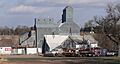
Main Street in McLean, November 2010
|
|

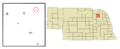
Location of McLean, Nebraska
|
|
| Country | United States |
| State | Nebraska |
| County | Pierce |
| Area | |
| • Total | 0.10 sq mi (0.25 km2) |
| • Land | 0.10 sq mi (0.25 km2) |
| • Water | 0.00 sq mi (0.00 km2) |
| Elevation | 1,837 ft (560 m) |
| Population
(2020)
|
|
| • Total | 33 |
| • Density | 347.37/sq mi (134.54/km2) |
| Time zone | UTC-6 (Central (CST)) |
| • Summer (DST) | UTC-5 (CDT) |
| ZIP code |
68747
|
| Area code(s) | 402 |
| FIPS code | 31-30065 |
| GNIS feature ID | 2399297 |
McLean is a small village located in Pierce County, Nebraska, in the United States. It is part of the larger area known as the Norfolk Micropolitan Statistical Area. In 2020, about 33 people lived in McLean.
Contents
The Story of McLean
McLean began to grow when the Chicago, Burlington and Quincy Railroad built its tracks through this area. There are a couple of ideas about how the village got its name. Some people think it was named after Donald McLean, who worked for the railroad. Others believe it was named after a place called McLean, Ohio.
The village also got its own post office in the year 1900.
Where is McLean?
McLean is a very small village. According to information from the United States Census Bureau, the total area of the village is about 0.10 square miles (0.25 square kilometers). All of this area is land, meaning there are no lakes or large rivers within the village limits.
Who Lives in McLean?
| Historical population | |||
|---|---|---|---|
| Census | Pop. | %± | |
| 1920 | 81 | — | |
| 1930 | 96 | 18.5% | |
| 1940 | 82 | −14.6% | |
| 1950 | 67 | −18.3% | |
| 1960 | 73 | 9.0% | |
| 1970 | 67 | −8.2% | |
| 1980 | 46 | −31.3% | |
| 1990 | 49 | 6.5% | |
| 2000 | 38 | −22.4% | |
| 2010 | 36 | −5.3% | |
| 2020 | 33 | −8.3% | |
| U.S. Decennial Census | |||
The number of people living in McLean has changed over the years. In 1930, it had its largest population with 96 residents. By 2020, the population was 33 people.
McLean's Population in 2010
In 2010, there were 36 people living in McLean. These people lived in 18 different homes, and 9 of these were families. The village had about 360 people per square mile.
Most of the people living in McLean at that time were White. About 22% of the homes had children under 18 years old. Half of the homes were married couples living together. Also, 44% of all homes had just one person living there. About 28% of these single-person homes were people aged 65 or older.
The average age of people in McLean was about 44.5 years old. The population included people of all ages, from children under 18 to seniors over 65. Slightly more than half of the residents were female (52.8%), and the rest were male (47.2%).
Images for kids
-
Main Street in McLean, November 2010
-
Location of McLean, Nebraska
See also
 In Spanish: McLean (Nebraska) para niños
