
McLean, Texas facts for kids
Quick facts for kids
McLean, Texas
|
|
|---|---|
 |
|

Location of McLean, Texas
|
|
 |
|
| Country | United States |
| State | Texas |
| County | Gray |
| Area | |
| • Total | 1.16 sq mi (3.00 km2) |
| • Land | 1.16 sq mi (3.00 km2) |
| • Water | 0.00 sq mi (0.00 km2) |
| Elevation | 2,861 ft (872 m) |
| Population
(2020)
|
|
| • Total | 665 |
| • Density | 573.3/sq mi (221.7/km2) |
| Time zone | UTC-6 (Central (CST)) |
| • Summer (DST) | UTC-5 (CDT) |
| ZIP code |
79057
|
| Area code(s) | 806 |
| FIPS code | 48-45780 |
| GNIS feature ID | 2412968 |
McLean is a small town located in Gray County, Texas, United States. It's part of the Pampa area. In 2020, about 665 people lived there.
Contents
Where is McLean Located?
McLean is in the southeastern part of Gray County. A major highway, Interstate 40, runs through the southern edge of the town. This highway can take you east about 185 miles to Oklahoma City or west about 74 miles to Amarillo.
An older road, U.S. 66, also known as Interstate 40 Business, goes right through the town. It's called First Street when heading west and Railroad Street when heading east. Texas State Highway 273 is on the western side of McLean and leads north to Pampa, which is the main city in Gray County.
The town covers a total area of about 3.0 square kilometers (1.16 square miles), and all of it is land.
A Look Back: McLean's History

McLean started in 1901 thanks to Alfred Rowe, an English rancher. He gave land near a railroad stop where cattle were loaded onto trains. The railroad company then built a water well and a small station there. The town was named after Judge William P. McLean, who was important in the Texas Legislature.
The town grew quickly! By 1904, McLean had several stores, a bank, places for wagons and horses, a lumber yard, and its own newspaper called the McLean News. A windmill in the middle of Main Street pumped water for everyone. In 1909, McLean officially became a town. It became a hub for farming.
In 1927, the famous U.S. Route 66 was built through McLean. This made the town a popular stop for travelers and a center for oil, livestock, and farm products. By 1940, about 1,500 people lived there, and it had many businesses and churches. From 1942 to 1945, a special camp was built east of town. It housed about 3,000 German prisoners during World War II.
Over time, bigger cities like Amarillo and Pampa grew more. McLean slowly became smaller. In 1984, Interstate 40 was completed, bypassing the old U.S. Route 66 through McLean. This meant fewer travelers came directly through the town.
Who Lives in McLean?
| Historical population | |||
|---|---|---|---|
| Census | Pop. | %± | |
| 1910 | 633 | — | |
| 1920 | 741 | 17.1% | |
| 1930 | 1,521 | 105.3% | |
| 1940 | 1,489 | −2.1% | |
| 1950 | 1,439 | −3.4% | |
| 1960 | 1,330 | −7.6% | |
| 1970 | 1,183 | −11.1% | |
| 1980 | 1,160 | −1.9% | |
| 1990 | 849 | −26.8% | |
| 2000 | 830 | −2.2% | |
| 2010 | 778 | −6.3% | |
| 2020 | 665 | −14.5% | |
| U.S. Decennial Census 2020 Census |
|||
In 2000, there were 830 people living in McLean. Most residents were White, with a small percentage of other racial backgrounds. About 2% of the population was Hispanic or Latino.
Many households were families, but also many people lived alone. The average age in McLean was 50 years old, meaning there were quite a few older residents. The average income for a household was around $22,847.
Education in McLean
Students in McLean attend schools within the McLean Independent School District. The town is home to the McLean High School, whose sports teams are known as the McLean Tigers.
The Lovett Memorial Library
The Lovett Memorial Library opened on August 9, 1940, in McLean's City Hall. The city council helped fund it, and a library board was set up to manage it.
Today, the library is located at 302 N. Main Street. It offers public computers, Wi-Fi, fax and printing services, movies, audiobooks, and a wide selection of books. It's part of a larger library system in the Texas Panhandle.
Historic Places in McLean
The downtown area of McLean, known as the McLean Commercial District, is listed on the National Register of Historical Places. It was added to this special list on December 20, 2006. This means the area is important for its history and is protected.
Images for kids
-
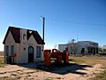
A former Phillips 66 gas station in McLean, Texas.

See also
 In Spanish: McLean (Texas) para niños
