
Meade Islands facts for kids

Meade Islands (in the background) from Miziya Peak, Livingston Island
|
|

Meade Islands
Location in Antarctica

Meade Islands
Location in Antarctic Peninsula
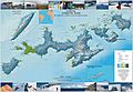
Location of Meade Islands
|
|
| Geography | |
|---|---|
| Location | Antarctica |
| Coordinates | 62°27′04″S 60°04′03″W / 62.451222°S 60.0675°W |
| Archipelago | South Shetland Islands |
| Area | 66 ha (160 acres) |
| Administration | |
| Administered under the Antarctic Treaty System | |
| Demographics | |
| Population | Uninhabited |
The Meade Islands are a small group of islands in Antarctica. They are found near Greenwich Island in the South Shetland Islands. This group includes two bigger islands, Zverino Island and Cave Island, plus a smaller one called Pisanitsa Island. There are also a few rocks nearby.
These islands are located at the northern entrance of McFarlane Strait. In the early 1800s, people who hunted seals visited this area.
How the Islands Got Their Name
The Meade Islands were first mapped in 1935 by a group called Discovery Investigations. They named the islands after C.M. Meade. He was a cartographer, which means he made maps, for the British Navy's map-making office at that time.
Where are the Meade Islands?
The Meade Islands are in a chilly part of the world! They are located in the South Shetland Islands, which are near the continent of Antarctica.
To give you an idea of where they are:
- They are about 1.98 kilometers (1.23 miles) west of Duff Point on Greenwich Island.
- They are also about 3.73 kilometers (2.32 miles) north of Pomorie Point.
- You can find them about 3.5 kilometers (2.2 miles) east of Williams Point.
Many countries, including Britain, Chile, Argentina, Spain, and Bulgaria, have mapped this area over the years.
Images for kids
-
A topographic map showing Livingston Island, Greenwich, Robert, Snow, and Smith Islands.

