
Zverino Island facts for kids

Zverino Island (in the background, on the left) from Miziya Peak, Livingston Island
|
|

Location of McFarlane-Strait in the South Shetland Islands
|
|

Zverino Island
Location in Antarctica

Zverino Island
Location in Antarctic Peninsula
|
|
| Geography | |
|---|---|
| Location | Antarctica |
| Coordinates | 62°27′09″S 60°04′25″W / 62.45250°S 60.07361°W |
| Administration | |
| Administered under the Antarctic Treaty System | |
| Demographics | |
| Population | Uninhabited |
Zverino Island (which means "Zverino Island" in Bulgarian) is a cool, icy island located in Antarctica. It's the biggest and most western island in a group called the Meade Islands. You can find it at the northern entrance of McFarlane Strait, which is part of the South Shetland Islands.
This island is about 1.2 kilometers (0.75 miles) long and 700 meters (0.43 miles) wide. It covers an area of about 48 hectares (119 acres). During the summer, the island is mostly free of snow. Zverino Island got its name from a town called Zverino in Western Bulgaria.
Where is Zverino Island?
Zverino Island is located in a busy part of the South Shetland Islands. It is about 2.4 kilometers (1.5 miles) east of Williams Point. It is also about 2.1 kilometers (1.3 miles) northeast of Ficheto Point on Livingston Island.
To the west, it is 1.9 kilometers (1.2 miles) from Duff Point on Greenwich Island. A narrow channel called Glogovo Passage separates Zverino Island from its neighbor, Cave Island. This passage is about 110 meters (360 feet) wide.
Mapping the Island
Many countries have helped to map Zverino Island and the surrounding areas. British explorers mapped it in 1935 and again in 1968. Chilean maps were made in 1971, and Argentine maps in 1980. Spain created maps in 1991. More recently, Bulgaria made maps in 2005 and 2009.

Images for kids
-
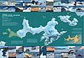
A topographic map of Livingston Island and Greenwich Island.
-
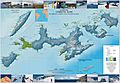
Another topographic map showing Livingston Island and nearby islands.


