Pisanitsa Island facts for kids

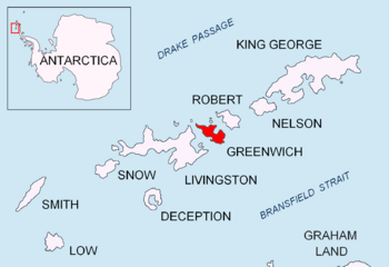
Location of Greenwich Island in the South Shetland Islands
|
|
|
Location of Pisanitsa Island
|
|
| Geography | |
|---|---|
| Location | Antarctica |
| Coordinates | 62°26′48″S 60°03′14.5″W / 62.44667°S 60.054028°W |
| Archipelago | South Shetland Islands |
| Administration | |
| Administered under the Antarctic Treaty System | |
| Demographics | |
| Population | Uninhabited |
Pisanitsa Island is a small, rocky piece of land located near the bottom of the world, in a very cold place called Antarctica. It's part of a group of islands known as the South Shetland Islands. This island is quite small, stretching about 270 meters (that's like two and a half football fields) in one direction and 60 meters wide. It's named after a place in Bulgaria, a country far away in Europe.
Pisanitsa Island is part of the Meade group of islands. It lies just off the Archar Peninsula, which is the northwest tip of Greenwich Island. In the early 1800s, people who hunted seals often visited this area.
Where is Pisanitsa Island?
Pisanitsa Island is located in the South Shetland Islands, which are a chain of islands near the Antarctic Peninsula. To be more exact, it is:
- About 1.26 kilometers west and slightly north of a spot called Duff Point.
- Only 120 meters northeast of Cave Island.
- About 3.6 kilometers southeast of Pyramid Island.
Scientists and mapmakers have been charting this area for many years. British maps showed this island in 1968, and Bulgarian mapmakers created their own maps in 2009.
Maps of the Area
If you want to see Pisanitsa Island on a map, you can look at special topographic maps of Antarctica. These maps show the shape of the land and its features.
One example is a map created by L.L. Ivanov. It shows Livingston Island and nearby islands like Greenwich, Robert, Snow, and Smith Islands. The map is very detailed, with a scale of 1:120000. It was first published in 2009 by the Manfred Wörner Foundation. A second edition came out in 2010.


