Medora Site facts for kids

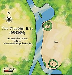
Diagram of the Medora Site
|
|
| Location | Plaquemine, Louisiana, West Baton Rouge Parish, Louisiana, United States |
|---|---|
| Region | West Baton Rouge Parish, Louisiana |
| Coordinates | 30°19′36.34″N 91°12′5.65″W / 30.3267611°N 91.2015694°W |
| History | |
| Founded | 1300 CE |
| Cultures | Plaquemine culture |
| Site notes | |
| Excavation dates | 1939-1940 |
| Archaeologists | James A. Ford, George I. Quimby |
| Architecture | |
| Architectural styles | Platform mounds, Plaza |
| Responsible body: private | |
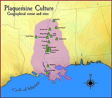
The Medora Site (also known as 16WBR1) is an important archaeological site. It's a "type site" for the prehistoric Plaquemine culture period. This means it helps archaeologists understand and define what the Plaquemine culture was like. The site is named Medora because it's close to the town of Plaquemine, Louisiana.
The Medora Site is located in West Baton Rouge Parish, Louisiana. People lived there from about 1300 CE to 1600 CE. The site had two large mounds with a flat area called a plaza between them. In the winter of 1939-40, archaeologists from the Louisiana State Archaeological Survey dug up parts of the site. This project was a team effort between Louisiana State University and the Work Projects Administration. The main archaeologists leading the dig were James A. Ford and George I. Quimby. Their work at Medora was very important for learning about the Plaquemine culture.
Contents
Discovering the Medora Site
Where is the Medora Site?
The Medora Site is found in West Baton Rouge Parish, Louisiana. It sits right next to Bayou Bourbeaux, a small river, on a flat area called Manchac Point. Manchac Point is a sharp bend in the Mississippi River. Bayou Bourbeaux flows away from the river to the west and connects to Bayou Gross Tete.
The land around the site is often wet and can flood every year. It's only about 20 feet (6 meters) above sea level. The site is part of a larger area called the Medora Plantation, which is how it got its name. Before the archaeologists started digging, this land had been farmed for many years.
When was the Medora Site Used?
Archaeologists and geologists worked together to figure out when people lived at the Medora Site. They used maps of old river paths made by Harold Norman Fisk. These maps showed that the Mississippi River started moving across the area of Manchac Point around 900 CE.
The land where Medora is located wasn't fully formed until about 1300 CE. This means people couldn't have lived there before that time. Also, all the items found at the site belonged to the Plaquemine period. There were no items from the later Natchez period, which started around 1700 CE. Based on this, experts believe the Medora Site was used from about 1300 CE to 1600 CE.
What Were the Mounds Like?
The Medora Site's main features were its large mounds and a central plaza.
Mound A: A Big Platform
Mound A was a platform mound, which is a type of mound with a flat top. It was about 125 to 130 feet (38 to 40 meters) wide at its base and 10 feet (3 meters) tall. The sides of the mound sloped inward towards the flat top. In one corner of the top, there was a round bump about 25 feet (7.6 meters) across. This bump made that part of the mound 13 feet (4 meters) high. It's likely that a square or rectangular temple stood on top of this mound.
Mound B: A Smaller Structure
About 400 feet (122 meters) southeast of Mound A was a smaller mound called Mound B. It was originally about 100 feet (30 meters) wide and 5 feet (1.5 meters) high. Over time, farming and floods have changed it, and now it's only about 2 feet (0.6 meters) high. Mound B also had a flat top, but its shape was more oval.
Archaeologists found traces of a building, possibly a house or temple, on the ground before Mound B was built. The floor of this building had patches of burned clay and pieces of charcoal. In the center, there was a round fire pit about 2 feet (0.6 meters) wide and 6 inches (15 cm) deep, lined with burned clay. Both mounds were built using gray clay and brown silt, carried in baskets.
The Plaza: A Central Gathering Place
Between Mound A and Mound B was a large, flat area called a plaza. It was about 400 feet (122 meters) long and 200 feet (61 meters) wide. The western side of the plaza was next to Bayou Bourbeaux. This plaza was likely a central spot for ceremonies or games.
What Did They Find?
Pottery: Clues from Clay

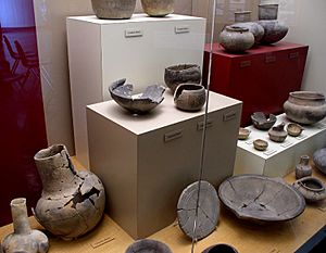
Archaeologists found a huge number of pottery pieces at the Medora Site, about 18,508 in total! These pieces were sorted into more than twenty different types of Plaquemine culture pottery. Most of the pottery (about 90 percent) was a plain type called Addis Plain. Other types found included Plaquemine Brushed, Medora Incised, and Larto Red Filmed.
The pottery from Medora was generally soft, made with clay, and not fired at very high temperatures. Most pieces were gray or tan and felt smooth and chalky. While most of the pottery was plain, about 10 percent had decorations. These designs were usually simple lines made by scratching, engraving, brushing, or poking holes. Incising (scratching lines) and brushing were the most common ways to decorate. Some pieces had more complex curvy designs. The decorations were usually on the outside of the pots, mostly near the rim. The most common pottery shapes were jars and bowls, along with some cups.
Stone Tools and Objects
Even though many pottery pieces were found, only seven stone artifacts were discovered at the Medora Site. Some reddish pebbles of flinty stone were found in Mound A. These stones don't naturally occur near Medora, so they must have been brought there, possibly from the area around Natchez, Mississippi.
Only three chipped flint projectile points (like arrowheads) were found. However, several objects made of polished greenstone and sandstone were discovered. These included two oval-shaped greenstone celts (axe-like tools) and a sandstone discoidal (a disc-shaped object) from Mound A. A spoon-shaped object of polished greenstone was found in Mound B.
The discoidal was probably used in a game called chunkey. This game was played by many Native American groups in the Southeast. It's very likely that chunkey games were played as part of ceremonies in the plaza at the Medora Site. Archaeologists also found a cylindrical earspool (an ornament worn in the ear) made of fired clay in Mound A. It was about 3 cm (1.2 inches) wide and 1.8 cm (0.7 inches) thick, with engraved geometric designs.
Who Dug Up the Site?
The land where the Medora Site is located was part of the Medora Plantation and had been farmed for many years. In the winter of 1939-40, the Louisiana State Archaeological Survey began digging at the site. This was a joint project between Louisiana State University and the Work Projects Administration.
The excavation was led by James A. Ford and George I. Quimby. Their work at Medora was very important for understanding the features of the Plaquemine period and culture. The owner of the land, W. L. Grace, Jr., gave permission for the archaeologists to investigate the site.


