Melba Line facts for kids
Quick facts for kids Melba Line |
|
|---|---|

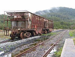
The Melba Line at Rosebery
|
|
| Overview | |
| Status | Open |
| Owner | Government of Tasmania |
| Locale | West Coast, Tasmania |
| Termini | Burnie Melba Flats (current) Zeehan (original) |
| Stations | 3 |
| Service | |
| Type | Heavy rail |
| Operator(s) | TasRail |
| History | |
| Opened | 1 February 1878 (1st stage) 21 December 1900 (in full) |
| Technical | |
| Line length | 130 km (81 mi) |
| Track gauge | 1,067 mm (3 ft 6 in) (after relaying) |
| Highest elevation | 670 m (2,200 ft) |
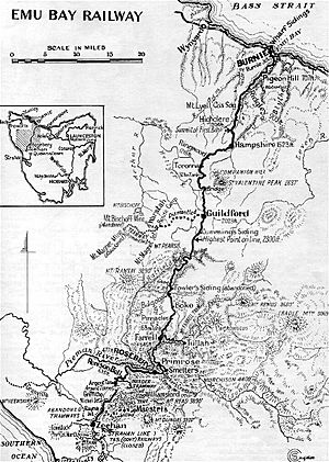
The Melba Line is a railway track on the West Coast of Tasmania. It is a narrow-gauge railway, which means its tracks are closer together than standard tracks. This line was first built as a private railway called the Emu Bay Railway. It was one of Australia's longest-running and most successful private train companies.
Today, the line goes from Burnie to Melba Flats. In the past, it went all the way to Zeehan. It carried minerals and passengers. This made it a very important service for the West Coast community.
Contents
History of the Melba Line
Early Construction and Changes
In the 1870s, the Van Diemen's Land Company hired John C. Climie. His job was to survey a railway line. This line would run from near Burnie to Mount Bischoff. On February 1, 1878, a 71-kilometer (44-mile) wooden tramway opened. Horses pulled the carts on this tramway. It went from Emu Bay (Burnie) to Rouse's Camp. This camp was near Waratah. The tramway helped serve the Mount Bischoff tin mines.
In 1887, a new company took over the line. It was called the Emu Bay to Mount Bischoff Railway Company. They changed the tracks. They used steel rails instead of wood. The tracks were made into a 1,067 mm (3 ft 6 in) gauge railway. This change allowed steam locomotives to use the line.
Extension to Zeehan
In 1897, the Emu Bay Railway Company took over. They extended the line by 60 kilometers (37 miles). On December 21, 1900, the line reached Zeehan. This made the railway much longer and more useful.
Later Changes and Ownership
The line between Rosebery and Zeehan closed in August 1965. This happened after the Murchison Highway opened. In 1967, EZ Industries bought the line. They improved it to carry heavier trains. The line reopened in January 1970. It ran from Rosebery to Melba Flats.
During the building of the Pieman River hydro electric scheme in the late 1970s, parts of the line were moved. New bridges were also built.
In October 1984, the Melba Line was sold again. It was part of the sale of EZ Industries to North Broken Hill Peko. This company later joined with CRA Limited to form Pasminco in 1988. In 1989, a new 11-kilometer (7-mile) branch line opened. It went from Moorey Junction to serve Aberfoyle's Hellyer Mine.
On May 22, 1998, Pasminco sold the line to the Australian Transport Network. It became part of their Tasrail business. In February 2004, it was sold to Pacific National. Finally, in September 2009, the government-owned TasRail bought the line.
Stopping Places Along the Line
When steam trains were running, the railway had about 23 stopping places. These included places for water and other passenger stops. Here are some of them:
- Burnie
- Pigeon Hill
- Ridgley
- Highclere
- Hampshire
- Ringwood
- Toronna
- Wey River Bridge
- Guildford - This was a junction, a place where another line connected. This line went to the Mount Bischoff tin mine.
- Rouse's Camp (Mount Bischoff branch line)
- Magnet Junction (Mount Bischoff branch line)
- Waratah (Mount Bischoff branch line)
- Mount Magnet (Magnet Tramway)
- Muddy Creek
- Bulgobac
- Boko
- Farrell Junction - This was a junction with the North Mount Farrell Tramway. This tramway went to Tullah. It is now known as the Wee Georgie Wood Railway.
- Primrose
- Barkers Crossing
- Rosebery
- Renison Bell
- Argent Tunnel
- Melba Flats
- This was a junction with the North East Dundas Tramway. This tramway went to Montezuma and Williamsford. These places are on the southern slopes of Mount Read.
- Rayna Junction - This was a junction with the Maestris or Mount Dundas – Zeehan Railway.
- Zeehan
Beyond Zeehan, the Tasmanian Government Railways line continued. It went to Regatta Point. From there, it connected with the Mount Lyell line to Queenstown.


