Melville, Western Australia facts for kids
Quick facts for kids MelvillePerth, Western Australia |
|||||||||||||||
|---|---|---|---|---|---|---|---|---|---|---|---|---|---|---|---|

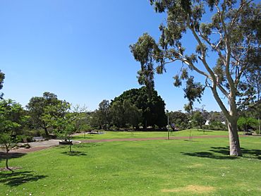
Kadidjiny Park, Melville
|
|||||||||||||||
| Postcode(s) | 6156 | ||||||||||||||
| Area | 2.4 km2 (0.9 sq mi) | ||||||||||||||
| LGA(s) | City of Melville | ||||||||||||||
| State electorate(s) | Bicton | ||||||||||||||
| Federal Division(s) | Tangney | ||||||||||||||
|
|||||||||||||||
Melville is a friendly suburb located in Perth, Western Australia. It is part of the larger area known as the City of Melville. This suburb is a great place to live, with a mix of homes and local facilities.
Contents
History of Melville
How Melville Got Its Name
Melville is named after a nearby part of the Swan River called Melville Water. This water area was given its name by Governor James Stirling. He chose the name to honor Robert Dundas, 2nd Viscount Melville.
The name "Melville" was first used in this area for a place called the Melville Park Estate. This happened way back in 1896. So, the suburb has a long history connected to the river and important people from the past.
Getting Around Melville
Bus Services in Melville
Buses are a great way to travel around Melville and to other parts of Perth. Several bus routes serve the suburb, making it easy to get to different places like train stations or the city center.
Here are some of the main bus routes that go through Melville:
- Bus 111 travels from Fremantle Station to the WACA Ground. It uses Canning Highway.
- Bus 114 goes from Lake Coogee to Elizabeth Quay Bus Station. This route serves Marmion Street.
- Bus 502 connects Fremantle Station to Bull Creek Station. It travels along Leach Highway.
- Bus 910 is a frequent service from Fremantle Station to Perth Busport. It also uses Canning Highway.
- Bus 915 is another frequent service. It runs from Fremantle Station to Bull Creek Station and serves Marmion Street.
These bus routes help people in Melville get to school, work, or other activities easily.
 | Frances Mary Albrier |
 | Whitney Young |
 | Muhammad Ali |

