
Palmyra, Western Australia facts for kids
Quick facts for kids PalmyraPerth, Western Australia |
|||||||||||||||
|---|---|---|---|---|---|---|---|---|---|---|---|---|---|---|---|

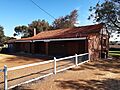
The historic Millers' Bakehouse Museum, Palmyra
|
|||||||||||||||
| Postcode(s) | 6157 | ||||||||||||||
| Area | 3.1 km2 (1.2 sq mi) | ||||||||||||||
| Location | 16 km (10 mi) from Perth | ||||||||||||||
| LGA(s) | City of Melville | ||||||||||||||
| State electorate(s) | Bicton / Fremantle | ||||||||||||||
| Federal Division(s) | Fremantle | ||||||||||||||
|
|||||||||||||||
Palmyra is a suburb located in Perth, Western Australia. It is part of the City of Melville. This area is about 16 kilometers (10 miles) southwest of the main city center of Perth.
Contents
History of Palmyra
Palmyra was first set up as the Palmyra Estate in 1903. It is located to the east of Fremantle. The name "Palmyra" comes from an ancient city in Syria.
Schools and Community Places
Palmyra has several important community buildings, including schools and churches.
Local Schools
- The Palmyra Primary School opened in 1913. It is on McKimmie Road. In 2013, the school celebrated its 100th birthday!
- Our Lady of Fatima School is also in Palmyra. It is connected to the Catholic Our Lady of Fatima Church.
Churches in Palmyra
Several churches serve the community in Palmyra:
- St Peter and St Mark Anglican Church
- The Uniting Church
- The Seventh Day Adventist Church
Exploring Palmyra's Boundaries
Palmyra has clear boundaries that help define where the suburb is.
Main Roads and Landmarks
- To the north, Palmyra is bordered by Canning Highway.
- Stock Road forms the eastern boundary.
- Sainsbury Road is on the south side.
- On the west, the boundary follows Carrington Street and Petra Street.
- The Fremantle Cemetery is also located at the southeastern edge of Palmyra.
Parks and Green Spaces
Palmyra is home to many parks and open spaces where people can relax and play.
Fun Parks to Visit
- King Victor's Green: This park is where you can find the Miller Bakehouse Museum.
- Emily Main Park: A nice green space south of Palin Street.
- Geo Thompson Park: Located across from Palmyra Primary School.
- Woolshed Park: A larger park bounded by McGregor Road.
- Dark Park: Found at the corner of Carrington Street and McGregor Road.
- Dinosaur Park: A fun spot at the corner of Carrington and Aurelian Streets.
- Three Bears Park: Located at the corner of Adrian and Tamar Streets.
- Oz Park: You can find this park at the corner of Aurelian and Justinian Streets.
- John O'Sullivan Park: Situated at the corner of Marmion and Baal Streets.
- Bill Sheehy Park: This park is between Justinian Street, McGregor Road, and Leach Highway.
- Lou Stonham Park: Borders Stock Road, near McGregor Road and Forrest Street.
Other Open Areas
- There is also a public open space at the corner of Justinian and Solomon Streets.
- Reddings Reserve is another green area that interrupts Baal Street.
Images for kids
-
The historic Millers' Bakehouse Museum, Palmyra

All content from Kiddle encyclopedia articles (including the article images and facts) can be freely used under Attribution-ShareAlike license, unless stated otherwise. Cite this article:
Palmyra, Western Australia Facts for Kids. Kiddle Encyclopedia.