East Fremantle, Western Australia facts for kids
Quick facts for kids East FremantlePerth, Western Australia |
|||||||||||||||
|---|---|---|---|---|---|---|---|---|---|---|---|---|---|---|---|

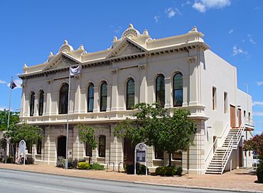
The East Fremantle Town Hall, located on Canning Highway.
|
|||||||||||||||
| Established | 1890s | ||||||||||||||
| Postcode(s) | 6158 | ||||||||||||||
| Area | 3.1 km2 (1.2 sq mi) | ||||||||||||||
| Location | 17 km (11 mi) from Perth | ||||||||||||||
| LGA(s) | Town of East Fremantle | ||||||||||||||
| State electorate(s) | Bicton / Fremantle | ||||||||||||||
| Federal Division(s) | Fremantle | ||||||||||||||
|
|||||||||||||||
East Fremantle, often called East Freo, is a friendly suburb in Perth, Western Australia. It's about 13 kilometers (8 miles) southwest of Perth's main city area. This place is mostly made up of homes and covers the same area as the local government called the Town of East Fremantle.
East Fremantle used to be a rural area outside Fremantle. Most of it grew into a suburb in the late 1890s and early 1900s. This happened because of the exciting Western Australian gold rushes. More homes were built in the 1940s and 1950s for new people moving to Australia. Two big roads, Canning Highway and Stirling Highway, go through East Fremantle. The Swan River forms its northern border.
Contents
A Look Back in Time
Early Days
Before Europeans arrived, the Noongar people lived here. They found food and water along the river and in open grassy areas. Soon after the Swan River Colony was started, a path connecting Perth to Fremantle was marked through this area.
In April 1833, a false rumor spread about a large group of Aboriginal people. It was said they had attacked a ferryman and his wife near Preston Point. This caused many people from Fremantle to rush out, some with guns, some without. Later, the Perth Gazette newspaper reported that the story was completely untrue. The newspaper criticized how easily such "extravagant and absurd statements" were made up.
Growing into a Suburb
At first, the area was mostly farms. But after the 1890s gold rush, more and more homes were built. It became a suburban area. The first part to grow was Plympton, in the southwest. Workers' cottages were built there between 1890 and 1910. Next, Woodside and Richmond developed in the south and north. Today, you can see many brick and tile homes from 1900 to 1940 in these areas. The Preston Point area grew in the 1950s.
Where is East Fremantle?
East Fremantle is bordered by the Swan River to the north and west. East Street is to the southwest, Marmion Street to the south, and Petra Street to the east.
What's in East Fremantle?
East Fremantle is a place where people live. For daily needs, residents use local shops nearby. For bigger shopping or services, they go to Fremantle. The suburb has a community center, two small private hospitals, and two primary schools. Every December, East Fremantle hosts a fun festival in George Street, which is a historic part of Plympton.
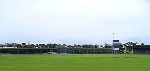
The suburb is also home to East Fremantle Oval. This is the home ground for the East Fremantle Football Club. This club plays in the West Australian Football League (WAFL).
Getting Around
Past Transport Ideas
In September 1910, a group called the South Swan Railway League was formed. They wanted a railway line built south of the Swan River. This line would go from Fremantle to Guildford. From there, it would connect to the existing Eastern Railway.
Roads and Buses
East Fremantle has an important crossroads where Canning Highway and Stirling Highway meet. Many buses serve the suburb from Fremantle train station. From there, people can connect to the CircleRoute bus service. They can also travel to the Perth central business district. All bus services are run by the Public Transport Authority.
- Bus 111 goes from Fremantle Station to WACA Ground. It travels along Canning Highway.
- Bus 148 goes from Fremantle Station to Como. It uses Canning Highway, Preston Point Road, Parker Street, and View Terrace.
- Bus 158 goes from Fremantle Station to Elizabeth Quay Bus Station. It also uses Canning Highway, Preston Point Road, Parker Street, and View Terrace.
- Bus 910 is a frequent service from Fremantle Station to Perth Busport. It travels along Canning Highway.
- Bus 915 is a frequent service from Fremantle Station to Bull Creek Station. It travels along Marmion Street.
Learning in East Fremantle
East Fremantle has one state-run primary school called Richmond Primary School. It was founded in 1921. The school has a kindergarten for 40 students on site. It also has an off-site pre-primary for 54 students. The main primary school teaches about 340 students. In 2011, the school had a total of 407 students. Richmond Primary is sometimes used by the local community. It also shares hosting an annual fête (a type of fair) with other local schools.
East Fremantle Primary School was started in 1898. It is located in the nearby suburb of Fremantle. It's just outside the border between Fremantle and East Fremantle, on Marmion Street. Most of East Fremantle is in the Richmond Primary school area. However, the Plympton area is part of East Fremantle Primary's school zone.
Students from East Fremantle can attend one of three secondary schools. These are John Curtin College of the Arts in Fremantle, Melville Senior High School in Melville, and South Fremantle Senior High School in Beaconsfield. Both Richmond Primary and East Fremantle Primary schools are used as polling booths. This is where people go to vote during elections.
 | DeHart Hubbard |
 | Wilma Rudolph |
 | Jesse Owens |
 | Jackie Joyner-Kersee |
 | Major Taylor |


