Meneage facts for kids
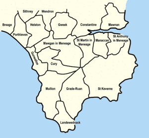
The Meneage (pronounced Men-AYG) is a special area in west Cornwall, United Kingdom. It's located south of the Helford River. The closest big towns are Falmouth and Penryn. (The coordinates above show the approximate center of the Meneage district.)
The name Meneage means "Monkish land." This suggests that after the Roman times, this area might have been owned by groups of small Celtic monasteries. These religious communities may have been started by missionaries from Brittany, a region in France.
For over 1,000 years, the northeastern part of the Lizard peninsula has been known as Meneage. It's a popular local name, but it doesn't have any official government meaning.
The Meneage area is made up of four main parishes and part of a fifth. These parishes are like local districts. From west to east, they include St Mawgan in Meneage (only a part of it), St Martin in Meneage, Manaccan, St Anthony in Meneage, and St Keverne.
Contents
Exploring Meneage Parishes
Let's take a closer look at the different parishes within the Meneage district. Each one has its own history and interesting features.
St Mawgan in Meneage
The church in St Mawgan is named after St Mauganus. St Martin's church is actually a smaller chapel that belongs to this parish. Remember, only a part of the St Mawgan parish is actually inside the Meneage district.
St Martin in Meneage
The church here is dedicated to St Martin of Tours, a famous saint. This church is also a chapel connected to Mawgan in Meneage. In 1385, it was given the right to bury people. Long ago, there were chapels dedicated to two Breton saints, St Melor and St Anou, in this area.
Manaccan
In 1308, St Manacca was recorded as the patron saint of this parish. However, it's thought that the name "Manaccan" might mean "Monks' Church." Today, the church is dedicated to both St Manaccus and St Dunstan.
St Anthony in Meneage
The village of St Anthony in Meneage is located near Gillan Harbour. The church is dedicated to St Anthony. It's a bit of a walk from the main village area.
St Keverne
There was once a monastery in St Keverne. It continued to exist even after the Normans conquered England. However, it later came under the control of a regular person, not a religious leader. The church here is dedicated to St Akeveranus. Within this parish is a place called Lesneague. Its name might come from Cornish words meaning "court" and "monks' land." This suggests it might have been where a local leader lived long ago.
Local Government in Meneage
The Meneage area has a special electoral ward called St Keverne and Meneage. An electoral ward is a district used for voting in local elections. This ward stretches all the way to the western coast of the Lizard at a place called Gunwalloe. In 2011, about 5,220 people lived in this ward.
Understanding Meneage Geology
The rocks and land formations in the Meneage district are quite complex. Geologists, who study the Earth's structure, now understand them much better than in the past.
The Meneage Formation
The Meneage area is named after a specific type of rock layer called the Meneage Formation. This formation is mostly made of mudstone. It also contains pieces of other rocks, including sedimentary, metamorphic, and igneous rocks. These pieces can be very large, with some Ordovician quartzite blocks reaching up to 200 meters (about 650 feet) in length.
This rock formation is part of a larger group called the Devonian Gramscatho Group. It can be as thick as 1,500 meters (nearly a mile). Some volcanic rocks found in the upper parts of the formation are thought to be from the Upper Devonian period.
The rocks in this area have undergone a process called metamorphism. This means they have changed due to heat and pressure deep underground. This process has created new minerals within the rocks.
 | Emma Amos |
 | Edward Mitchell Bannister |
 | Larry D. Alexander |
 | Ernie Barnes |


