Meno, Oklahoma facts for kids
Quick facts for kids
Meno, Oklahoma
|
|
|---|---|

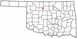
Location of Meno, Oklahoma
|
|
| Country | United States |
| State | Oklahoma |
| County | Major |
| Area | |
| • Total | 0.19 sq mi (0.50 km2) |
| • Land | 0.19 sq mi (0.50 km2) |
| • Water | 0.00 sq mi (0.00 km2) |
| Elevation | 1,345 ft (410 m) |
| Population
(2020)
|
|
| • Total | 198 |
| • Density | 1,031.25/sq mi (398.55/km2) |
| Time zone | UTC-6 (Central (CST)) |
| • Summer (DST) | UTC-5 (CDT) |
| ZIP code |
73760
|
| Area code(s) | 580 |
| FIPS code | 40-47750 |
| GNIS feature ID | 2412983 |
Meno is a small town located in Major County, Oklahoma, in the United States. In 2010, about 235 people lived there. This was a good increase from the 195 people counted in 2000. By 2020, the population was 198.
History of Meno
The town of Meno got its name from a famous Mennonite leader named Menno Simons. It was founded on October 19, 1899, by David Koehn. He accidentally left out one "n" when he filled out the paperwork for the Post Office! Jacob A. Wedel was the first postmaster.
Meno was first part of Woods County. When Oklahoma became a state in 1907, Meno became part of Major County. Many of the first people to live in Meno were Mennonites. They came from places like Poland and Russia. These families started the New Hopedale Mennonite Church.
Meno was also the first home of Oklahoma Bible Academy. This school was started in 1911 by the New Hopedale Mennonite Church. It was first called Meno Preparatory School. In 1983, the school moved to a nearby city called Enid, Oklahoma.
In the early 1900s, a railway line was built through Meno. This line connected the cities of Enid and Greenfield. By 1918, Meno had grown quite a bit. It had a bank, a flour mill, two creameries, and two places to store grain.
Today, Meno is mostly a "bedroom community." This means many people who live in Meno travel to work in the larger Enid area.
Geography of Meno
Meno is located about 15 miles (24 km) west of Enid.
According to the United States Census Bureau, the town covers a total area of 0.2 square miles (0.5 square kilometers). All of this area is land.
Population Changes in Meno
The number of people living in Meno has changed over the years. Here's a look at the population counts from different years:
| Historical population | |||
|---|---|---|---|
| Census | Pop. | %± | |
| 1910 | 69 | — | |
| 1920 | 92 | 33.3% | |
| 1930 | 96 | 4.3% | |
| 1940 | 180 | 87.5% | |
| 1950 | 76 | −57.8% | |
| 1960 | 118 | 55.3% | |
| 1970 | 119 | 0.8% | |
| 1980 | 171 | 43.7% | |
| 1990 | 155 | −9.4% | |
| 2000 | 195 | 25.8% | |
| 2010 | 235 | 20.5% | |
| 2020 | 198 | −15.7% | |
| U.S. Decennial Census | |||
In 2000, there were 195 people living in Meno. There were 78 households, and 56 of these were families. The population density was about 1,036 people per square mile (400 people per square kilometer).
About 27% of the people were under 18 years old. About 24% were 65 years or older. The average age in Meno was 40 years old.
See also
 In Spanish: Meno (Oklahoma) para niños
 | William M. Jackson |
 | Juan E. Gilbert |
 | Neil deGrasse Tyson |

