Metcalf, Holliston, Massachusetts facts for kids
Quick facts for kids
Metcalf
|
|
|---|---|
|
Village
|
|

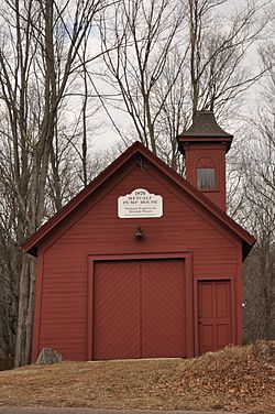
The Metcalf Pump House, constructed c.1870, decommissioned 1899
|
|
| Etymology: Named for landowner Stephen Metcalf Jr., who lived at the intersection of Summer & Washington St. throughout the mid-19th century |
|
| Nickname(s):
Springville
(de facto name circa 1850) |
|
| Country | United States |
| State | Massachusetts |
| County | Middlesex |
| Elevation | 244 ft (74 m) |
| Time zone | UTC-5 (Eastern (EST)) |
| • Summer (DST) | UTC-4 (EDT) |
| ZIP code |
01746
|
| Area code(s) | 508 |
| GNIS feature ID | 611709 |
Metcalf is a small community, also known as a village, located in the town of Holliston, Massachusetts. It is part of Middlesex County in the state of Massachusetts, United States. An unincorporated village means it's a community that is part of a larger town rather than being its own separate town with its own government.
Metcalf does not have its own post office. It was once an important stop for trains on the Boston and Albany Railroad line. Today, Metcalf is known for its historic pump house and other old buildings. These structures are located near the main intersection of Washington Street and Summer Street. In the past, Metcalf also had a school and small farms. Now, it is mostly a place where people live, with some small businesses and the local Fatima Shrine.
Where is Metcalf Located?
Metcalf does not have official borders set by the United States Census Bureau. Its main point is at the intersection of Washington Street and Summer Street in Holliston, Massachusetts. The U.S. Geological Survey also agrees with this central location.
Based on old maps, Metcalf seems to be located within these areas:
- To the north and east, it reaches Underwood Street.
- To the west, it extends to the Cedar Swamp.
- To the south, it borders the town of Medway.
Metcalf is surrounded by:
 | Victor J. Glover |
 | Yvonne Cagle |
 | Jeanette Epps |
 | Bernard A. Harris Jr. |

